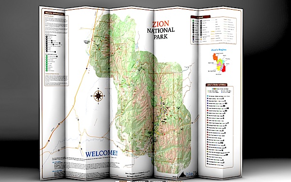
Day Hikes Of Zion National Park folds into a nice, waterproof, portable guide to Zion's day hikes/hike734
You're planning a trip to Zion National Park in Utah, you plan to do some hiking, and you're wondering which trails to search out.
You could pick up a copy of 50 Best Short Hikes In Utah's National Parks, which would be a good start in identifying some hikes in Zion. But a new "map guide" from Jake Bramante, the guy who hiked all 734 miles of Glacier National Park in one year, would be a good investment, too, if you're solely interested in day hiking in the park.
Day Hikes of Zion National Park, which provides details on 29 hikes in the park, is printed on tear-resistant, waterproof paper that folds down to a roughly 4.5-inch by 9-inch brochure that you can stuff in your back pocket or day pack. Unfold it and you find a map of the park with key facilities (restrooms, visitor center, lodging, picnic areas, etc) marked along with numbered hikes. Shuttle bus stops in the park as well as neighboring Springdale also are numbered to help you catch a ride.
This map is similar to Bramante's Day Hikes Of Glacier National Park. Hikes in the Zion guide are color-coded by region in the park. So if you look at all the purple-coded hikes, you'll know they're in the same general area of the park; in this case, in Zion Canyon. Green circles denote trails on the West Rim, violet is tagged to those on North Creek, yellow indicates southwest desert, light blue is The Narrows, and red is Kolob Canyons and the East Rim. Lines denoting the trails are even color coded: green for easy, yellow for moderate, and red for strenuous.
The map color codes hikes by region, and uses more colors to denote easy, moderate, and strenuous hikes/hike734
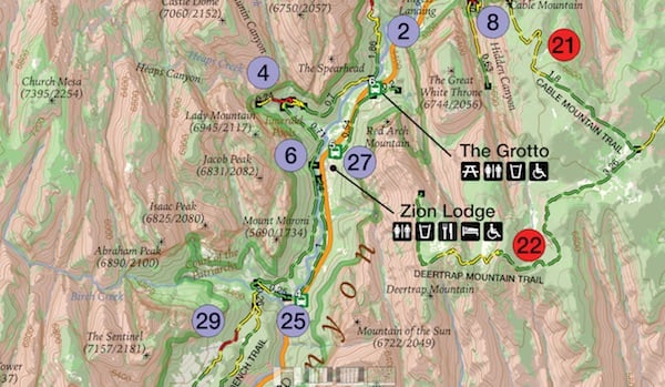
A glance at "Jake's Order of Hikes, which lists his favorites in descending order, tells you whether you'll encounter steep cliffs, whether a particular hike is family friendly, and whether the trail is accessible.
On the back of the map you'll find a breakdown of the trails with descriptions. Here Bramante segregated the hikes by distance, so you can quickly identify the mileage so you don't overdo it. You'll also find a box of safety information, ranging from steep cliffs in the park to the need to drink lots of water in this desert setting and even symptoms of heat stroke.
There's even a small box of information on where you can obtain additional books and maps.
If day hiking is your goal, this is a good tool to help you plan, and pull off, your day-long journeys in Zion. You can order a copy at Mr. Bramante's website.
Stories about:
Story Categories:
A copy of National Parks Traveler's financial statements may be obtained by sending a stamped, self-addressed envelope to: National Parks Traveler, P.O. Box 980452, Park City, Utah 84098. National Parks Traveler was formed in the state of Utah for the purpose of informing and educating about national parks and protected areas.
Residents of the following states may obtain a copy of our financial and additional information as stated below:
- Florida: A COPY OF THE OFFICIAL REGISTRATION AND FINANCIAL INFORMATION FOR NATIONAL PARKS TRAVELER, (REGISTRATION NO. CH 51659), MAY BE OBTAINED FROM THE DIVISION OF CONSUMER SERVICES BY CALLING 800-435-7352 OR VISITING THEIR WEBSITE. REGISTRATION DOES NOT IMPLY ENDORSEMENT, APPROVAL, OR RECOMMENDATION BY THE STATE.
- Georgia: A full and fair description of the programs and financial statement summary of National Parks Traveler is available upon request at the office and phone number indicated above.
- Maryland: Documents and information submitted under the Maryland Solicitations Act are also available, for the cost of postage and copies, from the Secretary of State, State House, Annapolis, MD 21401 (410-974-5534).
- North Carolina: Financial information about this organization and a copy of its license are available from the State Solicitation Licensing Branch at 888-830-4989 or 919-807-2214. The license is not an endorsement by the State.
- Pennsylvania: The official registration and financial information of National Parks Traveler may be obtained from the Pennsylvania Department of State by calling 800-732-0999. Registration does not imply endorsement.
- Virginia: Financial statements are available from the Virginia Department of Agriculture and Consumer Services, 102 Governor Street, Richmond, Virginia 23219.
- Washington: National Parks Traveler is registered with Washington State’s Charities Program as required by law and additional information is available by calling 800-332-4483 or visiting www.sos.wa.gov/charities, or on file at Charities Division, Office of the Secretary of State, State of Washington, Olympia, WA 98504.
INN Member

The easiest way to explore RV-friendly National Park campgrounds.

Here’s the definitive guide to National Park System campgrounds where RVers can park their rigs.
Our app is packed with RVing- specific details on more than 250 campgrounds in more than 70 national parks.
You’ll also find stories about RVing in the parks, tips helpful if you’ve just recently become an RVer, and useful planning suggestions.

Comments
Going in a couple of weeks. I see it is available at the VC but was hoping to get a copy earlier. Is there a place to buy online?
So much for quality control, eh, EC?
Just added a line for ordering: www.hike734.com
Ordered. Thanks
Off topic - but about the Parks. Planning a trip on the CDT in RMNP this summer. Trying to figure out an iternary through the backcountry sites. I can't find anywhere where the site GPS coordinates are listed. As I search, I see alot of commentary about GPS coords not being available for NPS locations. Does the NPS have a policy of not making those available? Shouldn't this be part of the basic info available on the websites? Would appreciate comments from anyone with insights.
Can't speak for other National Parks and GPS coordinates, but we've found Acadia posting some coordinates, some of which we've referred to in updating our latest edition of "Best Easy Day Hikes, Acadia National Park."
By searching "GPS coordinates" in the Acadia search field, we found this link:
http://www.nps.gov/acad/planyourvisit/gpscoordinates.htm
Maybe same search term would work for RMNP.
That is a start Acadia but it doesn't cover the backcountry campsites. Nor is it in a GPX file.
EC, I'm guessing the NPS doesn't have the staff or $$$ to go out and generate GPS coordinates for its trails. That said, I wonder if the relatively low traffic numbers along the CDT are behind the lack of some commercial GPS program. I noticed Garmin, I believe, or maybe it was DeLorme, had GPS packages for some other long-distance trails.
I find that hard to accept. I am assuming the rangers hike the trails and visit the campsites on a frequent basis. How much time/$$$ would it take to "mark" while on the way. I would think they would want that information for their own uses.
Let me know next time (1) you run into a ranger in the backcountry, and when you do, (2) ask if she/he has a GPS with her/him and if she'/he's making waypoints, (3) if she/he and her/his buddies do a data dump to create a list of GPS coordinates for individual trails and campsites, and (4) if they pass that list to their webmaster for posting.
Obviously at least one of the answers to your questions is "no". The next logical question is, why not.
Maybe a few possible questions/ answers: (1) How many GPS units are available to backcountry rangers to carry around on a daily basis? (2) Are those units of adequate quality to capture the level of accuracy / detail needed for the project under discussion?; (3) There simply hasn't been enough demonstrated demand for this information to get it done.
Bet you a cup of coffee that if staff time were being spent on this project - and that includes compiling all the field data and putting into some useable form for visitors - somebody would be complaining about the waste of tax dollars on a product that would be provided by the private sector if these was really a need / demand for it.
I'd rate this as one of many "nice to have" projects, but certainly not essential.
Unless those campsites are moving on a "daily basis" not many would be needed. I would think in 1 year, a single unit could be walked down every trail past every campsite in the park.
The typical off the shelf consumer unit can be with in a few feet - so yes.
Neither I nor you know whether that is true though the massive investment in GPS technology and the plethora of sites with GPS data on other hikes would suggest otherwise to me.
A quick search found these resources for GPS waypoints in NW parks:
http://www.wta.org/hiking-info/basics/how-to/how-to-prepare-for-backpack...
The Nat'l Geo maps seem to be more than fifteen, and include Arches, Canyonlands, Carlsbad, Crater Lake, Delaware Water Gap, Everglades, Grand Canyon, Guadalupe Mountains, Hawaii Volcanoes, Lassen, North Cascades, Shenandoah, Smokies, Saguaro, Sequoia-Kings, Tetons, Yellowstone, & Yosemite.
http://shop.nationalgeographic.com/ngs/category/maps/travel-and-hiking-maps
Why not just use Google Earth? I use it all the time to obtain GPS coordinates in all sorts of places. I used it last fall for coordinates in Zion and found them to be almost right on. The work has already been done. All required is a little effort on the part of people who want to use them. In the time spent to complain here, one could have had all sorts of waypoints for Zion and virtually any place else on the planet. At no expense to the government, by the way. Shouldn't Tea Partiers rejoice over that?
Another excellent resource for visiting Zion is a book published by Zion Natural History Association and sold for $17.
ZION ADVENTURE GUIDE - EXPLORING ZION NATIONAL PARK by Greer Chesher. Well worth the dollars spent.
Well first, I don't thing Google Earth has the coordinates for all the backcountry sites in RMNP. If so, please provide the link.
Yes, thousands of people that want the coordinates could research them - as I ultimately did. Or the Park Service could have one person do it and provide the information to thousands of people that would appreciate it.
Add it to the maintenance backlog.
Google Earth does have all the coordinates. All one has to do is place the cursor over the campsite or trail junction or whatever you are looking for and PRESTO, there it is.
I just used G E to plot my hiking plans for a trip into Grand Staircase. It took all of maybe fifteen minutes and in the process, I discovered some interesting things I hadn't known about before. In addition to G E, there are a large number of online and CD disk sets of state topo maps. My Utah topos are from National Geographic. They work even better for some things than G E.
Wanting the government to do it for us without wanting to pay for it is a perfect example of the hypocrisy of the Tea Party Entitlement Mentality.
Now lets leave it up to other readers to make their own decisions here.
But those campsites aren't marked on G E.
Who said I wouldn't pay? Wouldn't my entrance fee be paying for this? Wouldn't the backcountry permit be paying for this? Wouldn't my taxes be paying for this. Heck, I find this a far more usefull and mission relevant expenditure than say the "artist in residence" program. The cost of creating this database is miniscule. Such GPX files are available, for free, for many other hikes. I downloaded one showing every Shelter on the AT. Another the plot of the entire Colorado Trail. As I said before, I would think this info would be valuable to the Park itself. In fact, I would be surprised if they don't already have the information. Or if they asked for it, hikers would give it to them for free.
http://www.everytrail.com/best/hiking-zion-national-park
Excellent resource for trails, waypoints, photos, and gps files.
Thank you dahkota. That looks like one more fine resource. I've bookmarked it and will be checking it more thoroughly.
I've had to change this response 3 times now as other posts come in faster than I can get to this reply.
1: Getting the coordinates for campgrounds, trails, etc., does not involve rangers or even volunteers marching around with GPS units. By now all parks should have roads, trails, and all facilities and named locations as GIS data: "Base Cartography" was one of the 12 core inventories for the ~280 units with natural resources. [We use polylines of trails to design sampling schemes for monitoring new invasive weeds, to compute travel times for monitoring crews and for SAR.] Technically, the process would take a bit of review for closed or re-routed trails and campsites (data get outdated), then not much more than a GIS tech using the ArcGIS Data Interoperability Extension to dump the data in GPX format usable by most brands of consumer GPS units, dropping all attributes except the trail or site name. [2 potential issues: I suspect that the GPX files are a format our webserver blocks, so users would download a .txt file and have to rename it; folks selling apps or downloadable GPX files can potentially prevent NPS from competing with them.]
2: I think that a very few folks requesting coordinates for trail junctions, campgrounds, trails, etc., especially with 1 or 2 sentence use-cases for the trail as polylines in their requests, would be enough to get this done at most parks. I suspect that the issue is more that rangers & natural resource folks don't tend to use GPS units this way, so they don't understand why these coordinates would be useful to you. Many natural resource folks, data managers, and even some interp rangers can use ArcGIS. Make the request to individual parks; if they can't do it themselves they can ask their I&M network for support.
3: I don't know about any current NPS policy about providing GPS coordinates, liability, etc. . My understanding from long before I joined NPS is that there used to be substantial liability issues with providing sets of GPS coordinates: folks would plug them into their GPS in the wrong CRS (NAD27 instead of NAD83/WGS84) and blame the coordinate provider, or use them to attempt cross-country travel and end up an impassable cliffs and blame the coordinate provider, etc.. Many organizations & agencies with less than expert audiences quickly stopped providing coordinates. While I hope more GPS users now know what they're doing, modern handhelds are more idiot-proof, and GPX specifies WGS84 decimal degrees, to some extent providing GPS coordinates still promotes off-trail cross-country use. That can lead to folks coming to cliffs, dangerous stream crossings, etc., so I can see that neither SAR nor resource protection folks would make providing GPS coordinates to the general public a high priority (that doesn't mean that they would _oppose_ providing coordinates). Again, that is my personal impression and (non-NPS) experience, not NPS policy.
4: As several folks have noted, you can get your coordinates from google earth if you can recognize it from the aerial photography. If I were doing lots of points or tracing a trail or stream, I would use the push-pins for places and paths for trails, then right-click on the tree of points and save as kml; then use something like GPSBabel to convert that kml to GPX to upload to my GPS unit.
Duplicate post; my apologies.
I tried to finish my response while running a big slow data fetch from home.
Tomp2 - Your post sounds like it is coming from someone with some knowledge of the issue. Points 1 & 2 confirm my belief that the coordinates and/or resources to create them already exist.
Point three also is in line with my suspicions that not providing the coordinates is more a policy decision than anything else. I don't agree with the decision and think the "liability" issue is stupid, though in these litigious days, the PC correct thing to do. I don't see how there is any more liability in GPS coordinates than in those rough hand sketched maps they pass out. Its about time the rest of us stopped being penalized for the stupidity of a few.
On point 4) for trails I use Topo USA. Put a start pin at the start and a finish pin at the end and then one click createa a route. One more click and you have a direct download to the GPS from there. Campsites are another matter as they generally aren't shown in standard Topo sofware, are frequently invisable on Google Earth and are only approximated on such maps as Nat Geo where interpelation is needed to even get to the "approximate" location. GPS downloads from the National Park "Service" would be a nice "service" commenserate with (and cheaper than) interpretive signs, ranger presentations and park museums. But then I guess interpretive signs, ranger presentations and park museums are just Tea Pary entitlement mentality.
EC--
What I was trying to communicate is that it probably _isn't_ a NPS policy decision, and that I know of no NPS policy on providing GPS coordinates to the public. Rather, the park-level folks who would do this don't know that it is more of a priority to visitors than other things they're working on when they're not at the visitor center front desk. A few polite requests, with a use-case of why it would be helpful to you so that the ranger can explain or sell the request to their supervisors, are likely to do the trick. The key is that this will have to be done park by park, as local park folks need to check the data to make sure it is current and valid and safe (for instance, I know that Death Valley has some things in their "roads" GIS coverage that aren't roads that would be a serious safety issue if included in GPX files).
Then I would suggest someone(s) has made that decision. It may not be a written policy but it is what gets implimented.
Interesting. Just book a backcountry trip in RMNP. Asked about .gpx files on the campsites. The ranger said yes they have them and he would email them to me.
So indeed they exist. It would be nice to have them posted on the websites.
ec, it would be possible to come up with quite a list of items individual visitors might like for a park staff to provide, but the fact those items or pieces of information aren't already available doesn't mean a policy has been issued to prohibit their production or release.
You may disagree, but in my opinion the majority of NPS staffers who have the technical expertise to provide what you want here already have more than enough on their plates. As others have explained above, until there are enough requests to move this up on somebody's "to-do" list, it probably won't happen anytime soon.
And, some perspective is in order here from an admittedly old school hiker. Availability of GPS coordinates for backcountry sites is in the "nice to have" category. It would be useful for some visitors, but it's hardly critical for a safe trip, and as one comment above points out, unless it's up to date and verified, such info can lead some visitors astray or even into dangerous situations.
I was working on my comment above while you posted another one. See, no policy against such info. Sometimes, all you have to do is ask, and after several such requests, it's more likely to get posted somewhere.
So I guess that dispells all the earlier excuses. Its basic info and easily integrated into the websites. It would be nice to have.
Thank you Jim, I agree, I am not sure it is a responsibility of the public land agencies to post or allow for every "nice to have" piece of information. I was also delighted to see a comment on the importance of "Art in the Parks", "Artist in Residence Programs", etc and the extremely significant contributions these persons have made to our enjoyment and support of Parks and Wild Lands. Must include the Traveler website in the continuing effort.
"
and other efforts to continue the contributions made by writers, photgraphers, artists, etc.
Sorry Ron, I find backcountry campsites much closer to the Parks mission than some performing artist. And when a "nice to have" takes virtually no addional effort or monies I see little reason not to provide it. Are you suggesting we eliminate every interpretive sign, ranger program or park exhibit because they are only "nice to have"?
Man, someone makes a suggestion to improve the backcountry experience and NPS websites (two subjects already brought up here before) and you NPS defenders get your back hairs up in a jiffy. I'm not a NPS basher. All in all I think they do a very good job. That doesn't mean they can't be open to some suggestions. They probably are but seems like an awful lot of people here aren't.
I frequently get an overnight backcountry permit in Big Bend NP and they keep making the process easier and friendlier.
Actually, most parks coordinate GPS locations of park features, including backcountry camp sites, with in-house geographic information systems used to produce a variety of maps for purposes of resources management. These data are already in hand, but perhaps not released to the public via park web sites.
Personally, I do not see any downside, nor administrative difficulty, in making this information available as a public service. Perhaps it's only a matter of time and staff priorities.
Sorry Tomp2, I just now saw your posted information, which duplicates what I've said above.
In my experience the 'artist in residence' program is not a 'performing artist' [which puts me in mind of a singer or musician] but more often a painter or photographer. The product of such a program can benefit many.
"The Artist-In-Residence Program at Rocky Mountain National Park offers professional writers, composers, and visual and performing artists the opportunity to pursue their artistic discipline while being surrounded by the park's inspiring landscape"
http://www.nps.gov/romo/getinvolved/supportyourpark/artist_in_residence.htm
Apparently things vary. The announcement for the 2015 Chilkoot Trail Artist Residency program [a joint NPS/Parks Canada effort], which is local to me, mentioned visual artists.
Sorry, ec, if I seemed to push back too hard. Maybe getting the info posted online would take less time and effort than I realize, but I've seen too many cases of "quick and easy" projects that prove not to be as advertised. This is just one of many examples of competing priorities for employee's time, and if this is being worked on, then something else won't get done. As Owen says, it's a matter of setting priorities - and different people see what should be at the top of the list differently.
No doubt we all have different priorties. As my mom used to say, "thats why they don't make it all vanilla". And there is nothing wrong with that.
Do they have these maps available at a rngr station some where at the park enterance?