
Maps. They're the stuff of explanation, and dreams. Explanation of what lies out yonder on the landscape, and dreams of what yet's to come. If you're thinking of visiting Glacier National Park, either just to drive through on the Going-to-the-Sun Road, or to spend some time exploring the backcountry on hiking trails, there are two new maps to help bring your vision to fruition.
The maps -- Day Hikes Of Glacier National Park ($9.95) and Going-to-the-Sun Road, Driving Guide ($9.95) -- are the work of Jake Bramante, who put his mark on Glacier in 2011 when he hiked all 734 miles of trail in the park. With all that trail work, he knew he'd have to do something more than just talk about his experiences.
"The short story is that once I finished my project, I knew that I had a bunch of 'raw ore' as it were. I had folks ask me if I was going to do a guide, but I didn't just want to come out with a product just like the Falcon Guides, so I just sat on it," he explained via email. "Through 2012, I was busy editing down all of my trips to post as blogs, got married and helped out the (Glacier National Park) Conservancy. I read this super great book called $100 Startup, which really challenged me to listen to what my audience was saying and taking the answers to those questions into a product.
"When I was down in Maui on our honeymoon, we drove the road to Hana. We had a map, we had Maui Revealed, and some mile marker sorts of things to help out. I came back and realized that I have a very specific recommendation for how to drive Going-to-the-Sun Road," Jake continued. "I took all of those pieces from Hana and put them together in that map. I came out with that guide in the spring of 2013 and it sold decently. The more important piece was that it laid the foundation for the Day Hikes guide."
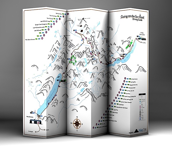
The Going-to-the-Sun map is straightforward: It uses a very rough sketch of mountains, streams and lakes that are found in Glacier, and depicts the route of the Sun Road from the West Entrance at West Glacier to the East Entrance at St. Mary. What makes it handy for the windshield tourist are highlights called out on the map -- waypoints, points of interest, lookouts, rest rooms, bus stops, and accessible areas.
Realizing that some travelers will be coming from the east, and some from the west, Jake put mileage markers reflecting the distance from each entrance next to each waypoint or point of interest. For instance, the Jackson Glacier Overlook (No. 14 on the map), is 12.4 miles from the East Entrance and 34.7 miles from the West Entrance. Flip the map over and you'll find short descriptions of the various points of interest.
The map of day hikes is a worthwhile guide for any Glacier visitor who thinks they might want to walk away from a parking area and down a trail. Within it you'll find 88 day hikes that feature color-coded sections to indicate trail steepness (green is relatively flat, red might take your breath away), descriptions of each trail, distances to travel, family friendly and early season hikes called out, and topographic lines to help you determine elevational changes. Plus, the map notes each of the 234 summits and high points in Glacier that are recognized by the Glacier Mountaineering Society.
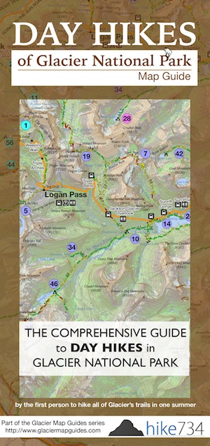
To help you choose a hike, Jake divided the park into eight regions -- North Fork, Goat Haunt, Belly River, Many Glacier, St. Mary, Two Medicine, Walton and Lake McDonald -- and color coded them, and then color coded each hike so you can quickly tell which region of the park it is in. On the back of the map he also broke out the hikes by distance, listing those that run 0-5 miles, 5-10 miles, 10-15 miles, and 15+ miles.
And if you're in a quandry over which hike to take, well, Jake offers suggestions of his favorites.
The maps are durable -- standing up to constant folding and unfolding, and even getting rained on or frozen -- as they're made out of plastic.
While the Sun Road map features a hand-sketched depiction of Glacier, Jake knew that wouldn't work for his hiking guide.
"So throughout the winter, I taught myself GIS software enough to get the map out. It was received with joy and people were purchasing them, then buying more for friends and such. I was blessed," said Jake.
What's next? He's mulling a backpacking map guide, but in the meantime is working on a day hiking guide to Zion National Park in Utah.
"I'm now probably 70 percent done with the Zion Day Hikes guide. I'm hoping to have it sent to the printer before the new year," he said. "After that, it will be to continually chip away at the highest visited hiking parks first Yellowstone, Yosemite, Grand Canyon, Rocky Mountain, Tetons, etc."
You can order the two Glacier maps, and stay atop of future maps, by visiting Jake's website.

Story Categories:
A copy of National Parks Traveler's financial statements may be obtained by sending a stamped, self-addressed envelope to: National Parks Traveler, P.O. Box 980452, Park City, Utah 84098. National Parks Traveler was formed in the state of Utah for the purpose of informing and educating about national parks and protected areas.
Residents of the following states may obtain a copy of our financial and additional information as stated below:
- Florida: A COPY OF THE OFFICIAL REGISTRATION AND FINANCIAL INFORMATION FOR NATIONAL PARKS TRAVELER, (REGISTRATION NO. CH 51659), MAY BE OBTAINED FROM THE DIVISION OF CONSUMER SERVICES BY CALLING 800-435-7352 OR VISITING THEIR WEBSITE. REGISTRATION DOES NOT IMPLY ENDORSEMENT, APPROVAL, OR RECOMMENDATION BY THE STATE.
- Georgia: A full and fair description of the programs and financial statement summary of National Parks Traveler is available upon request at the office and phone number indicated above.
- Maryland: Documents and information submitted under the Maryland Solicitations Act are also available, for the cost of postage and copies, from the Secretary of State, State House, Annapolis, MD 21401 (410-974-5534).
- North Carolina: Financial information about this organization and a copy of its license are available from the State Solicitation Licensing Branch at 888-830-4989 or 919-807-2214. The license is not an endorsement by the State.
- Pennsylvania: The official registration and financial information of National Parks Traveler may be obtained from the Pennsylvania Department of State by calling 800-732-0999. Registration does not imply endorsement.
- Virginia: Financial statements are available from the Virginia Department of Agriculture and Consumer Services, 102 Governor Street, Richmond, Virginia 23219.
- Washington: National Parks Traveler is registered with Washington State’s Charities Program as required by law and additional information is available by calling 800-332-4483 or visiting www.sos.wa.gov/charities, or on file at Charities Division, Office of the Secretary of State, State of Washington, Olympia, WA 98504.
INN Member

The easiest way to explore RV-friendly National Park campgrounds.

Here’s the definitive guide to National Park System campgrounds where RVers can park their rigs.
Our app is packed with RVing- specific details on more than 250 campgrounds in more than 70 national parks.
You’ll also find stories about RVing in the parks, tips helpful if you’ve just recently become an RVer, and useful planning suggestions.
