
The road into the Aspenglen Campground (top photo) just inside the park's Fall River Entrance was undercut by storm waters, while a section of Route 7 just south of Lily Lake was washed away. Downtown Estes Park saw Elkhorn Avenue turn into a stream, while the surging Fall River undercut banks near condos. Top two photos NPS, bottom two photos courtesy of Mel Tulin.
Roads severed. Walls of rock and mud blocking access. Trails washed out. That is some of the aftermath at Rocky Mountain National Park, where streams and rivers normally feeble at this time of year swelled to spring runoff levels and more after days of rain.
At the height of last week's series of storms, which arrived Wednesday and continued into Sunday, a foot of rain was received in one 24-hour period. By Thursday morning, campgrounds were being closed, rangers were dispatched into the backcountry to check on any travelers there, and communications were spotty at best.
Two women climbers, who headed out to scale Longs Peak before the storms set in in earnest, managed to safely hike down off the mountain Thursday.
Estes Park, Colorado, the eastern gateway to the park, itself became isolated, as Highways 34 and 36 up from Loveland and Lyons down below were overcome by flooding in places and closed to travel indefinitely. Downtown areas were inundated and flooded. The town's 15th annual "Elk Fest," scheduled for the last weekend of the month, was jeopardized by the flooding.
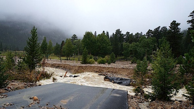
Elkhorn Avenue in the heart of downtown resembled a river at times, while many lodges along the Fall River were flooded. Some bridges from the Fall River Road crossing the river to provide access to lodges were washed over or out.
Within Rocky Mountain National Park, some of the most obvious storm damage was on the northern end of Horseshoe Park near Endovalley. In places the road into Endovalley was washed out and washed over with mud, rocks, and other debris. The road into the Aspenglen Campground also was damaged, and the bridge over the Fall River deemed unsafe for even foot traffic. In Moraine Park, the Big Thompson River ran bankful, as did the Fall River as it surged through Horseshoe Park.
The Roaring River, living up to its name, cleaved the Endovalley Road on the northern end of Horsehoe park. NPS photo.
How backcountry areas made it through the storm, particularly those areas burned by the Fern Fire last fall and winter, remained to be seen. With little or no ground cover in the burned areas, erosion could be substantial.
Throughout the storm event the park kept open the Trail Ridge Road, which runs from Estes Park on east side of the park across the Continental Divide to Grand Lake on the western side for essential and emergency traffic. The route allowed Estes Park area residents to return home from the west, and outbound travel west by people who needed to leave Estes Park, including local residents and park visitors who were forced out campgrounds by the storm waters.
When the park, which was closed Thursday, would reopen was not immediately known Sunday.
Story Categories:
A copy of National Parks Traveler's financial statements may be obtained by sending a stamped, self-addressed envelope to: National Parks Traveler, P.O. Box 980452, Park City, Utah 84098. National Parks Traveler was formed in the state of Utah for the purpose of informing and educating about national parks and protected areas.
Residents of the following states may obtain a copy of our financial and additional information as stated below:
- Florida: A COPY OF THE OFFICIAL REGISTRATION AND FINANCIAL INFORMATION FOR NATIONAL PARKS TRAVELER, (REGISTRATION NO. CH 51659), MAY BE OBTAINED FROM THE DIVISION OF CONSUMER SERVICES BY CALLING 800-435-7352 OR VISITING THEIR WEBSITE. REGISTRATION DOES NOT IMPLY ENDORSEMENT, APPROVAL, OR RECOMMENDATION BY THE STATE.
- Georgia: A full and fair description of the programs and financial statement summary of National Parks Traveler is available upon request at the office and phone number indicated above.
- Maryland: Documents and information submitted under the Maryland Solicitations Act are also available, for the cost of postage and copies, from the Secretary of State, State House, Annapolis, MD 21401 (410-974-5534).
- North Carolina: Financial information about this organization and a copy of its license are available from the State Solicitation Licensing Branch at 888-830-4989 or 919-807-2214. The license is not an endorsement by the State.
- Pennsylvania: The official registration and financial information of National Parks Traveler may be obtained from the Pennsylvania Department of State by calling 800-732-0999. Registration does not imply endorsement.
- Virginia: Financial statements are available from the Virginia Department of Agriculture and Consumer Services, 102 Governor Street, Richmond, Virginia 23219.
- Washington: National Parks Traveler is registered with Washington State’s Charities Program as required by law and additional information is available by calling 800-332-4483 or visiting www.sos.wa.gov/charities, or on file at Charities Division, Office of the Secretary of State, State of Washington, Olympia, WA 98504.
INN Member

The easiest way to explore RV-friendly National Park campgrounds.

Here’s the definitive guide to National Park System campgrounds where RVers can park their rigs.
Our app is packed with RVing- specific details on more than 250 campgrounds in more than 70 national parks.
You’ll also find stories about RVing in the parks, tips helpful if you’ve just recently become an RVer, and useful planning suggestions.

Comments
Last Wednesday night, the final leg of our annual Dumb & Dumber buddy trip found Colorado Jim and me driving through Boulder and then up Hwy 119/Canyon Blvd, following Boulder Creek, as we headed for CJ's home near Nederland. The rain was ferocious, Boulder's streets were beginning to flood, and Boulder Creek was a swollen torrent. It was clear that very bad things were about to happen. The next afternoon, as the "biblical flooding" along the Front Range closed one road after another with rockslides, floodwaters, exposed natural gas lines, and other hazards, CJ used a circuitous route (closed shortly thereafter) to drive me to a motel near the Denver airport so I could catch my flight home on Friday the 13th.
While watching nonstop news reports on a local TV station Thursday night I learned that Trail Ridge Road was being used as an evacuation route for people imperiled by the Big Thompson Canyon flooding. That got me to wondering what might have happened if large numbers of evacuees headed for Grand Lake had become stranded in their vehicles on Trail Ridge Road. What a nightmare that would have been!
Good observation, Bob. Anyone who has driven that mountain road knows it has plenty of places where falling rock and other problems can easily occur during rainstorms, and snow and ice are certainly a potential threat at higher elevations by this time in September. We can be thankful the evacuation went well, since it sounds like Trail Ridge Rd. was the only option in and out of Estes Park.
Completing cleanup and repairs in the park and nearby areas will be a challenge, since there isn't a lot of time before winter weather arrives. Dealing with extra costs for overtime, supplies and materials, etc. will be another challenge during the last two weeks of the fiscal year.
I'm surprised that throughout all the coverage given to the current disaster, there has been no mention of the Big Thompson flood that took place July 31, 1976.
It's very fortunate that disaster was not repeated. Perhaps lessons learned from that one helped save lives this time.
Here's a link to an article: http://www.thorntonweather.com/blog/severe-weather/34-years-ago-today-th...
I don't know about "lessons learned" as there was a big difference in the storms. The 1976 storm had a huge amount of rain in a very short period of time creating a 20 foot wall of water that came completely unexpected. This go round the rate of rain was less but over a much longer time frame. Flood levels this time are actually higher than in 1976 but the fact the rises took place over time, gave people more warning.
I believe ec is correct about the 1976 coming with less warning that the recent incident.This article has an overview of that disaster.
Another key point: In the past decade or so technology has vastly improved the ability to issue speedy warnings for residents. Based strictly on news reports (admittedly a sometimes risky source), it sounds like during last week's emergency the counties used the capability to issue warnings via the combination of e-mail, cell phone and automated calls to land-line phone.