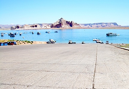
So far the Wahweap boat ramp at Glen Canyon National Recreation Area has been able to continue operations despite falling water levels in Lake Powell. NPS photo.
If you look forward each year to boating on Lake Powell at Glen Canyon National Recreation Area, you might want to consider a rain or snow dance upstream of the reservoir. Continued drops in the water level are creating some problem for those who need a ramp to launch their boat.
At Hite the ramp is high and dry, the ramp at Antelope Point basically is too high most of the time for launches, and at Bullfrog the ramp is out of the water.
In past years the National Park Service has even dug a channel, in effect, through the "Castle Rock Cut" to deal with shrinking water levels. And while the agency is seeking funding to further excavate the "cut" next year, unless the reservoir level rises any deeper channel there still would be above the waterline, according to Denise Shultz, the NRA's chief of interpretation, education, and partnerships.
“What we’re trying to do is to provide public access for as long as we can, depending on the lake level," she said earlier this week.
To keep the boat ramp at Wahweap open, down through the years more and more concrete has been added at the bottom. Currently, the ramp is about 1,200 feet long.
According to the NRA, the U.S. Bureau of Reclamation’s August 24-Month Study indicates that lake levels may continue to drop over the next two years, with the lowest predictions in March 2015 at approximately 3,536 feet. If that level is reached, it would represent a drop of more than 50 feet from the current lake level is about 3,590 feet, and roughly 170 feet below the "full pool" level of 3,700 feet.
“If you look at the lake levels over the last 50 years, it has gone from over a full pool to pretty darn low, and it will continue to fluctuate," Ms. Shultz said.
Runoff projections are not optimistic. The forecast for Lake Powell for the coming water year projects that the most probable (median) inflow volume will be 77 percent of average based on the period 1981-2010, according to the U.S. Bureau of Reclamation.
BuRec officials point out that there's quite a bit of variability to the annual inflows into Lake Powell.
"During the period 2005 through 2012, the unregulated inflow to Lake Powell ... averaged a water year volume of 10.22 million acre feet (94 percent of average (period 1981-2010). The unregulated inflow has ranged from a low of 4.91 maf (45 percent of average) in water year 2012 to a high of 15.97 maf (147 percent of average) in water year 2011," the agency notes on its website.
"This has been an improvement over the persistent drought conditions of 2000 to 2004, which averaged a water year unregulated inflow of 5.73 maf. However, based on observed inflows and current forecasts, water year 2013 unregulated inflow is expected to be 4.33 maf (40 percent of average), which would be a second significantly below-average year in a row. If this occurs, the period 2000-2013 would be the driest 14-year period on record with an average annual unregulated inflow of 8.20 maf per year. (For comparison, the standard 1981-2010 period average is 10.83 maf)."
Story Categories:
A copy of National Parks Traveler's financial statements may be obtained by sending a stamped, self-addressed envelope to: National Parks Traveler, P.O. Box 980452, Park City, Utah 84098. National Parks Traveler was formed in the state of Utah for the purpose of informing and educating about national parks and protected areas.
Residents of the following states may obtain a copy of our financial and additional information as stated below:
- Florida: A COPY OF THE OFFICIAL REGISTRATION AND FINANCIAL INFORMATION FOR NATIONAL PARKS TRAVELER, (REGISTRATION NO. CH 51659), MAY BE OBTAINED FROM THE DIVISION OF CONSUMER SERVICES BY CALLING 800-435-7352 OR VISITING THEIR WEBSITE. REGISTRATION DOES NOT IMPLY ENDORSEMENT, APPROVAL, OR RECOMMENDATION BY THE STATE.
- Georgia: A full and fair description of the programs and financial statement summary of National Parks Traveler is available upon request at the office and phone number indicated above.
- Maryland: Documents and information submitted under the Maryland Solicitations Act are also available, for the cost of postage and copies, from the Secretary of State, State House, Annapolis, MD 21401 (410-974-5534).
- North Carolina: Financial information about this organization and a copy of its license are available from the State Solicitation Licensing Branch at 888-830-4989 or 919-807-2214. The license is not an endorsement by the State.
- Pennsylvania: The official registration and financial information of National Parks Traveler may be obtained from the Pennsylvania Department of State by calling 800-732-0999. Registration does not imply endorsement.
- Virginia: Financial statements are available from the Virginia Department of Agriculture and Consumer Services, 102 Governor Street, Richmond, Virginia 23219.
- Washington: National Parks Traveler is registered with Washington State’s Charities Program as required by law and additional information is available by calling 800-332-4483 or visiting www.sos.wa.gov/charities, or on file at Charities Division, Office of the Secretary of State, State of Washington, Olympia, WA 98504.
INN Member

The easiest way to explore RV-friendly National Park campgrounds.

Here’s the definitive guide to National Park System campgrounds where RVers can park their rigs.
Our app is packed with RVing- specific details on more than 250 campgrounds in more than 70 national parks.
You’ll also find stories about RVing in the parks, tips helpful if you’ve just recently become an RVer, and useful planning suggestions.

Comments
According to Utah's Channel 5 (KSL) news, the deepening the channel could cost $1,000,000. The report noted that there is increasing pressure on NPS coming from the concessionaire that rents houseboats. Without the channel to cut off something like 12 extra miles if boats must follow the natural channel, rentals may drop off when renters realize how much extra gasoline will be needed to reach the "good" parts of the lake.
Is this a wise use of already tight dollars? Apparently some people in high places think so.
Looks like you could land a 747 on that ramp!!LOL