High water tables are being blamed by Cape Hatteras National Seashore officials for flooding problems in some low-lying areas, such as the Cape Point Campground. Undated file photos.
Wet weather this fall has created a problem of standing water at Cape Hatteras National Seashore, where officials say a high water table is responsible. Quick solutions, though, are not readily available, as various state and federal laws prevent the park from simply draining the water away.
While the national seashore has a drainage ditch system, it was built "decades ago before the Wetlands Protection Act and other modern environmental laws came into existence," says Cyndy Holda, the seashore's spokeswoman.
"The ditches were meant to reduce water levels in and around Cape Point Campground, which was built in a wetland, but ironically the drainage system had no fixed outlet, so the system holds water rather than drains it."
In years past, she says, the seashore staff would use heavy equipment to trench ditches to drain the water from wetlands areas and roads to the beach. However, when crews did that in 2004 the North Carolina Division of Water Quality issued a Notice of Violation to the seashore for violating state laws that prohibit draining wetlands, the spokeswoman added.
"The NPS has studied the issue for several years, and there are no easy fixes (such as cutting a "drain" any time high water occurs) that would be legal or appropriate," Ms. Holda said. "An NPS hydrologist and a wetland ecologist have visited the area since 2004 and written technical reports stating that the 2004 action not only violates state and federal law, it also violates NPS policy. Their assessment is that the area floods because of an elevated water table; in essence, the water table is 'above ground level' wherever there is standing water, which occurs over an extremely large area.
"The most practical long-term solution, with proper planning and compliance, may be to raise the road and provide proper drainage underneath the road, particularly since flooding seems to be occurring more often in recent years," she said.
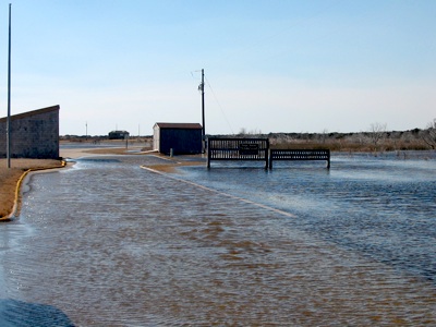
Areas impacted by heavy rains this fall (after Hurricane Irene) include the wetlands surrounding portions of Lighthouse Road near the Cape Point Campground and beach Ramp 44. A section of the eastern end of the road several hundred yards long has been under 6-12 inches of standing water for weeks, said Ms. Holda.
"ORVs have generally been able to drive through the water to reach Ramp 44, which for the most part has remained dry. Though not as convenient as Ramp 44, ORVs have also had reliable access to Cape Point from Ramp 49," she said. "We realize that some people would prefer that we simply cut a ditch (the "drain") to the ocean, like in the old days, to lower the water level across a large wetland area enough to reduce the standing water on the road; however, as stated previously, that would violate laws and policy and would not be appropriate in a unit of the national park system."
This coming winter the seashore staff plans to begin work on an environmental assessment that would evaluate the impacts of proposed infrastructure improvements. That document is expected to look at the options for addressing "the flood-prone eastern portion of Lighthouse Road," said Ms. Holda.
Story Categories:
A copy of National Parks Traveler's financial statements may be obtained by sending a stamped, self-addressed envelope to: National Parks Traveler, P.O. Box 980452, Park City, Utah 84098. National Parks Traveler was formed in the state of Utah for the purpose of informing and educating about national parks and protected areas.
Residents of the following states may obtain a copy of our financial and additional information as stated below:
- Florida: A COPY OF THE OFFICIAL REGISTRATION AND FINANCIAL INFORMATION FOR NATIONAL PARKS TRAVELER, (REGISTRATION NO. CH 51659), MAY BE OBTAINED FROM THE DIVISION OF CONSUMER SERVICES BY CALLING 800-435-7352 OR VISITING THEIR WEBSITE. REGISTRATION DOES NOT IMPLY ENDORSEMENT, APPROVAL, OR RECOMMENDATION BY THE STATE.
- Georgia: A full and fair description of the programs and financial statement summary of National Parks Traveler is available upon request at the office and phone number indicated above.
- Maryland: Documents and information submitted under the Maryland Solicitations Act are also available, for the cost of postage and copies, from the Secretary of State, State House, Annapolis, MD 21401 (410-974-5534).
- North Carolina: Financial information about this organization and a copy of its license are available from the State Solicitation Licensing Branch at 888-830-4989 or 919-807-2214. The license is not an endorsement by the State.
- Pennsylvania: The official registration and financial information of National Parks Traveler may be obtained from the Pennsylvania Department of State by calling 800-732-0999. Registration does not imply endorsement.
- Virginia: Financial statements are available from the Virginia Department of Agriculture and Consumer Services, 102 Governor Street, Richmond, Virginia 23219.
- Washington: National Parks Traveler is registered with Washington State’s Charities Program as required by law and additional information is available by calling 800-332-4483 or visiting www.sos.wa.gov/charities, or on file at Charities Division, Office of the Secretary of State, State of Washington, Olympia, WA 98504.
INN Member

The easiest way to explore RV-friendly National Park campgrounds.

Here’s the definitive guide to National Park System campgrounds where RVers can park their rigs.
Our app is packed with RVing- specific details on more than 250 campgrounds in more than 70 national parks.
You’ll also find stories about RVing in the parks, tips helpful if you’ve just recently become an RVer, and useful planning suggestions.

Comments
Try this link for an update.
http://wheatseyeonhatterasislandnc.blogspot.com/2011/11/update-on-floodi...
The NPS mangers have this correct. Draining
freshwater sedges in a National Park is illegal. ORV proponents should pursue constructive
alternatives (like raising the road and the campground) rather than draining a productive
maritime marsh in a national park.
SS1
According to the North Carolina Department of Water Quality, with whom I have had extensive discussions on this very subject, it is in fact LEGAL to drain these waters down to keep the road dry and surrounding areas as best as possible such as the campground, fish cleaning table area etc. All NPS needs do is obtain permission to do so which is easily done.
I don't know where you got your information SS1, but the persons involved in such an option disagree with you wholeheartedly excepting NPS who apparently have no issues with creating a biohazard in this area. Even their own 2005 study shows bacteria levels that far exceed NCDWQ levels considered a hazard to human health.
The property in question is a federal fresh water wetland that occasionally spills over on the NPS road, not state land. I believe if NPS mangers diverted that water to an ocean outfall it would be a violation of a number of federal laws and regulations. In any case National Parks are always held to the highest standers when it comes to environmental decisions such as draining wetlands. I guess this is why park mangers don’t agree with the ORV users solution.
The water in that sedge has not made anyone sick or caused any more of a “biohazard” than marshes anywhere else. The idea that wetlands are a biohazard was abandoned years ago, wetlands ecosystems have a cleansing affect on contaminated water. This particular wetland is a vital and important habitat for a considerable number of migratory birds in the Park and has not posed any hazard to them.
My take on this issue is that this is not about biohazards but a perceived inconvenience for visitors who want to access the Cape Point area of CHNS via an ORV. Driving slowly (and safely) through the puddles will rinse off much of the sand and salt that accumulates on vehicles that are leaving the NP Beach. Fix the road, the campground, and the fish-cleaning table. Don’t drain the marsh.
Pardon me SS1, but enterococcus bacteria counts in excess of 200/100ml are considered hazardous to human health and occur in the same waters people drive through, walk through and ride their bikes through. NPS studies conducted in 2005 have shown enterococcus levels at 1184/100ml. Recent testing has shown fecal coliform bacteria levels at a level three times the level considered hazardous to humans and as NPS reports, every time we have a fresh water event, these levels spike. The water in question has been upwards of a foot deep since September and grows deeper with every rain.
Unfortunately for you SS1, I actually do know what I'm talking about, I know who calls the shots with the water and I also know who is responsible for this hazard to include the now enormous Asian Tiger mosquito population in this area, a known vector for West Nile Virus.
If you care to educate yourself on the subject, I suggest you spend some time talking to the folks at NCDWQ.
From my observations, (over 50 years) this
entire area is normally seasonally wet during the fall and winter. I recently
drove through this area (11/27)
and the water in the road was no more than a few inches deep and posing no
problem to numerous vehicles that were accessing ramp 43 and 44. Migratory
waterfowl were present in the area.
It would be interesting to know who took the
samples of contaminated water and when and where they taken. The point source
of the contamination should be identified and corrected. Draining contaminated
water into the ocean beach is the wrong course of action.
There is potential habitat for the tiger
mosquito everywhere on Hatteras Island not just in the vicinity of the NPS
campground and road. In any case West Nile Virus does not seem to be an issue
on Hatteras Island. To quote from the local Dare County Website about West Nile
Virus, "Fortunately, the risk of catching West Nile virus is very low.
Even in areas where the virus is circulating, very few mosquitoes are infected
with the virus. Even if the mosquito is infected, less than 1% of people who
get bitten and become infected will get severely ill." I can't find any
reports of anyone contacting West Nile virus on Hatteras Island, (or any one
getting sick as a result of contaminated water on the NPS road)
Preserving the physiographic process is
specifically noted in the enabling legislation for CHNS. The dynamic changing
habitats that accompany these processes are protected. There are other ways of
insuring access to Cape Point beaches besides draining this area. For this and
many other reasons draining this slough is not the correct solution to the
flooding that occasionally inconveniences ORV users.
I reviewed Wheat’s blog, which I found to be
overwhelmingly dedicated to promoting ORV access and condemning NPS management
and conservation organizations, not public health issues. I believe this
is not an issue of public health but an issue of national park policy where
natural process would be subjugated for the convenience of special interests.
SS1
Though the water is only inches deep please get a flat tire, then proceed to drop a lugnut into it causing you to have to reach in and look for it not knowing that by doing so you are endangering your life...
Did you take samples of that water you were in?
With an incubation period of 2 to 15 days for West Nile and the average stay on Hatteras being only 7 days I guess there is a SMALL chance these people were diagnosed elsewhere after leaving... Perhaps they did not recognize the symptoms? Or maybe theyare like the other 4 out of 5 that do not have symptoms???
samsdad1
In case you’re missing the point, (you are
probably not) you can move your vehicle a couple of 100 yards to high ground to
change your flat. There is no
reason to change a tire in a puddle.
In any case I don’t know for certain where this contaminated water is
supposed to be or if it is still contaminated.
If West Nile Virus was a problem in Dare County
locals would have contracted it and it would be announced in one of the local
newspaper or blogs it hasn’t, it isn’t. Tiger mosquitoes would not locate
themselves just in one habitat next to the road that leads to Cape Point. There
is more of a problem with them breeding in old tires, buckets etc. West Nile
virus and Tiger Mosquitoes are a non sequitur. If you are worried about being
bit by a mosquito that could possibly be carrying West Nile Virus don’t come
anywhere near Dare County or CHNS. There are mosquitoes everywhere.
If you are worried about contaminated water in
the National Park I think you be more concerned about how it got contaminated rather
than draining it into the ocean where it could pose a problem to someone
fishing on the south beach.
True, where is the research for that...
Everyong is making this an ORV issue like everything else there. It is an access for everyone issue.
Some of us do not drive on the beach so this is my two cents about it.
I have a regular little car...sorry but when I was there I had to turn around because it was up to the bottom of my doors. I wasn't going to risk it to see if it got any deeper, just to much. And I sure as crap wasn't going to wade through water I couldn't see the bottom of it. It was dark and smelled bad. We could not make it to the parking area for us non beach driving folks so that eliminated us from enjoying the point this year. It is a long enough hike from the parking area there that my husband struggles from there, if we parked in a parking area further away we could not hike to the point.
If the NPS wants to keep the visitor count down to certain areas of the beach, well this is just another way of doing it by limiting the access by not maintaining the park as it should have over the years. I cannot imagine trying to camp in the campground anymore. It used to be a dry campground when we used to stay there, now it is wet! And it has not been in that many years to say that the sea level rise or water table etc has caused this.
It is sad to see the management of the park become such an un-visitor friendy place. It has been my favorite NP for over 30 years due to its beauty, diversity, history, people and nature. And to each year I visit see it become a place where visitors are not wanted and the park not cared for in a mannor that protects it (properly) and makes it accessable to all visitors is a shame. They have an opportunity to make this stand out above the rest but choose not. again shame on them.
This is not an ORV issue, pedistrains would have to walk through that water. We don't have an ORV and did not want to walk through the water. So we had to drive nearly 10 miles to find another beach access.
It seems that NPS spends less on maintenance and more on control and enforcement. The NPS certainly has its priorities screwed up.
This was not a wetland until the park dug a hole to save the light house, allowed it to fill with water and become a pond, then stopped managing the pond allowing it to grow by leaps and bounds after every hurricane and overwash event since the 1960's and raise the water table. Don't belive me go read Aycock Brown's Outer Banks--he has a picture of the area along with campground, picnic area, Amphitheater.
The hydrologist mentioned is a paid for park service contracter that will say what ever the park service wants him to--like saying the campground spetic system is not compromised and that bacteria levels are within norms. As Wheat pointed out this is untrue.
We have been complaining about this area since Isabel in 2003 and the record spring rains. Isabel flooded much of the island with ocean overwash, cut the island in several places and left Hatteras Village under water and without access to the rest of Hatteras Island for months. Clearly, this was an event that qualified us as a disaster area and would have allowed draining in some of the areas most affected. They did this in the gulf after Katrina, and Isabel was our Katrina.
Contrary to the reports from Cyndy we have not had anything more than average rainfall and we had .53 inches this week and a whopping 2 inches the week before, most of it 10 days before the decision. And don't tell me the ground was saturated because March was below average and April was only a little above average. I repeat this is an ongoing problem caused by man made activities that raised the water table and created a holding area for ocean overwash from south beach. I mean if the park service really gave a damn about visitors, they could have built a new campground and recreational support by now--they have only had 9 years to fix the problem. Furthermore, the park service promised residents the new long range plan would include a solution to flooding and health risks associated with it. Of course, the park service did not address this issue in the plan, except to raise the road. Now we have a new swamp, skeeter problems, etc.
Put it back the way it was (fill the pond, bulldoze the dunes, etc.) or manage the area--period.
I preface my statement with the words "I pray to God that what I am about to say is wrong."
I've seen very little that the park service has done to make this island a friendly place. The park service continuously looks the other way when there are problems and blames someone else.
What better way to destroy the vitality and economy of this island than to once again look the other way when swarms of west nile virus carrying mosquitios proliferate in the wet lands created and protected by the park service? Once again the park service will conveniently look the other way when a case of west nile virus on Hatteras Island is finally reported. That will surely be the final nail in this economy's coffin.
I must ask would you come anywhere near this island for your summer vacation or would you go somewhere else? As a resident I would seriously consider leaving.
I am a resident of Hatteras Island so trust me I know what I am talking about and if you don't believe me read the administrative history--Cape Hatteras National Seashore the Depression through Mission 66.
Hatteras and Ocracoke Islands are home to 8 villages which date back hundreds of years with grave yards to prove it. It is thought that Hatteras Island may be the home of some of the lost colony residents.
Hatteras and Ocracoke Islands are the last of the states barrier reef islands that are populated with the population totalling 4,000 people and a rich tradition of fishing and tourism which revolves around free and open access to the beaches of the islands.
The park service convinced residents to convey their land to the park, resulting in villages that are surronded by government property and at the mercy of government agencies for the ability to maintain their infrastructure by promising to allow continued traditional use of the island's beaches while protecting said beaches from the type of development seen in Nags Head, Kitty Hawk, and other villages to the north.
During the past 15 years or so the 4,000 residents have had the same government agencies stand in the way of infrastruct replacement and maintainence (bridge, roads, restrictions on maintainence of established waterways, etc.) threatening the health and welfare of the people. More recently, the residents have seen continued attempts to establish wildlife and research areas that minimize human presence on many of our beaches--the primary draw for the tourists the park promised to attract to the area.
In this instance we have an area where the park has violated its own mandate to protect natural processes by way of man made ponds, etc. The raised water table has destroyed maritime forest and bird nesting habitat. The raised water table has also limited the use of the area for recreational purposes--a use the park service promised to protect. And we, the residents are asked once again to pay the price.
Am I the only one that sees the above as a slow process of trying to depopulate these islands so that the environmental entities can finally say the entire barrier island chain is now available for birds? Sorry, we residents have a right to be here and those who trace their lineage back to the first colonies and the indians will fight for that right. I will join them. The rest of you should as well. It is a travesty when the government can force people from their homes by standing in the way of basic necessities (such a water in Tomestone and roads and electricy here) and the life blood of the local economies (such as farming in the CA valley and tourism here) all in the name of some fish or bird which can be protected by less extreme measures.