Two rivers in the National Park System facing two greatly divergent threats are ranked among the nation's most endangered rivers by the advocacy group American Rivers.
At Death Valley National Park in Nevada the Amargosa River is at risk from proposed mining that if approved could lead to reduced water flows and water quality issues. Across the country in Virginia the Potomac River that touches the Chesapeake and Ohio Canal National Historical Park and Great Falls Park is threatened not only by sewage leaks from aged pipelines but also data processing centers that consume large amounts of water for cooling and could be a source of toxic pollution.
Overall, the 10 rivers on American Rivers' Most Endangered Rivers® list are valued for the water they supply, the wildlife and other natural resources they support, and the recreation they offer. Nationally, according to the group, 80 percent of the country's rivers don't have the protection necessary to maintain their health.
“Polluting and abusing our rivers will impoverish our nation and ourselves. We should not shirk our responsibility to protect our most precious resource—our nation’s freshwater,” Tom Kiernan, president and CEO of American Rivers, said Tuesday when the group released its list. “Rivers are the foundation from which our nation has grown and if we allow vital water supplies to diminish and degrade, our children and the generations still to come will pay the price.”
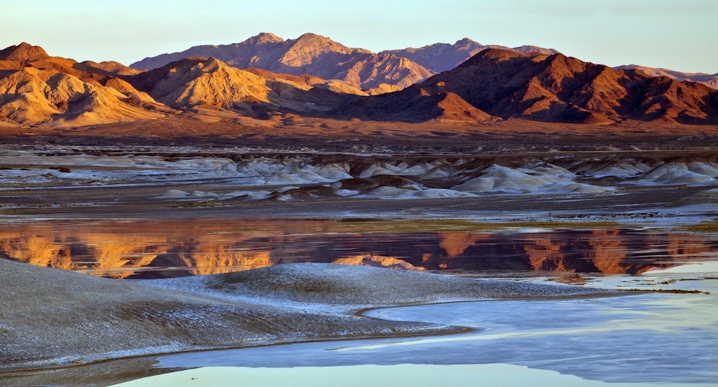
Amargosa River, Death Valley National Park
At Death Valley, the Amargosa River could be impacted by proposed mining near its headwaters and along the borders of Ash Meadows that puts the river flows at risk.
The river flows through Nevada and California, winding through the Mojave Desert before reaching the national park and ultimately terminating in the Badwater Basin. "Though much of the river flows underground, its groundwater and springs sustain unique plants and wildlife found nowhere else on Earth like the Devil’s Hole Pupfish," American Rivers said.
According to the organization, St. Cloud Mining’s Ash Meadows Mine project and Lhoist North America’s Amargosa Valley Mine are proposing to expand claystone mining operations. There are also hundreds of active mining claims for lithium on the border of Ash Meadows, it added in its report on the threats to the river.
"Current proposals involve exploratory drilling and mining of these minerals to or below the water table and may entail pumping of groundwater out of an open pit to access the ore," the report said. "The best available science has shown clearly that dewatering of open pits may put groundwater-fed springs in Ash Meadows and Death Valley National Park at risk of destabilization or drying, which would be catastrophic for the river’s fragile wildlife."
Chantel Dominguez, director of conservation partnerships for American Rivers, described the Amargosa River as "a vibrant ribbon of life in one of the driest landscapes in North America."
But, she added, "right now its future is in a precarious position. While the river and ecosystems it preserves are fragile, the fight to save them has united a strong, bipartisan movement dedicated to protecting their life-giving resources.”
Back in 2023 opposition to mining blocked exploratory drilling near Ash Meadows until a full review under the National Environmental Policy Act could occur. Last year, a coalition of tribes, nonprofits, local governments, and "thousands" of residents called for a mineral withdrawal for approximately 309,000 acres of Bureau of Land Management land surrounding Ash Meadows, a move that would protect the region from new mining for up to 20 years.
The Interior Department must approve the withdrawal before the temporary halt expires a year from now.
“We are calling on our leaders to save the Amargosa River,” said Carolyn Allen, chair of the town of Amargosa Valley, Nevada. “Our community is living under threat. We fight for every drop of water. Our beautiful river needs to be saved and protected. This can’t wait."
American Rivers and its partners also want Congress to designate the "Ash Meadows National Conservation Area" to provide a long-running solution for protection of groundwater, biodiversity, and tribal and rural communities.
Potomac River, Chesapeake & Ohio Canal National Historical Park and Great Falls Park
The Potomac River, which tops American Rivers' 2026 list, most recently suffered when a broken sewage pipe spewed hundreds of millions of gallons of raw sewage. The sewage was diverted into a dry section of canal in the historical park.
Not drawing as much attention has been the construction, and proposed construction, of thirsty data processing sites in Virginia.
“As the backdrop to our nation’s capital, the Potomac should reflect the highest standards of water health and stewardship,” said Pat Calvert, Virginia conservation director for American Rivers. “The Potomac is at an inflection point and cannot continue to sustain the rapid expansion of water-guzzling data centers drawing from its waters. Act now or watch this river be detrimentally redefined for the everyday citizen that depends on it.”
The Potomac flows nearly 400 miles from the Appalachian Highlands to the Chesapeake Bay. Its tributaries include the Shenandoah, Monocacy, Anacostia, North Branch, and South Branch rivers.
"The river supports internationally renowned recreational trout fisheries in its headwaters and some of the East Coast’s most significant oyster, blue crab, and striped bass commercial fisheries," noted American Rivers.
According to the group, many of the wastewater pipes in the region are beyond their 50-year service life. The Potomac Intercepter sewage line that failed earlier this year was more than 60 years old.
Data centers not only require a lot of water for cooling, but also are a source of toxic PFAS “forever chemicals," said American Rivers.
"The scale and pace of data center expansion is particularly concerning. Projects are often reviewed individually, rather than as part of a watershed-wide analysis, masking their combined impacts on stormwater runoff, chemical spill response, management of hazardous materials, groundwater withdrawals, and flood risk," the group said. "In many cases, there is little to no requirement for advanced stormwater treatment, long-term remediation planning, or disclosure of water use and discharge data. This lack of oversight creates dangerous gaps in understanding how these facilities affect downstream communities, ecosystems, and drinking water treatment costs."
Last month the National Parks Conservation Association warned about threats to the Potomac River tied to water withdrawals for data centers.
Currently, about 8 percent of the Potomac River’s permitted water withdrawals during the summer are going to data centers, according to calculations by Alimatou Seck, a senior water resources scientist at the Interstate Commission on the Potomac River Basin who was cited in NPCA's report. Over the next two to three decades, estimated withdrawals could reach 200 million gallons per day, with longer-term projections of total municipal water demand approaching or exceeding 600 million gallons per day, according to the NPCA report.
“Now is the time to advocate for the strongest protections possible for the Potomac River," said Lydia Lawrence, director of conservation
for Nature Forward, in comments provided by American Rivers. “This river, a critically important natural resource for the people and wildlife in our entire region, faces serious threats from unchecked data center development and the Potomac Interceptor pipeline spill. We urge federal, state, and local legislators to take swift action and pass policy that protects the immediate and future health of the Potomac.”
The Potomac River also topped American Rivers' 2012 list due to the threat from urban and agricultural pollution.
Stories about:
Story Categories:
A copy of National Parks Traveler's financial statements may be obtained by sending a stamped, self-addressed envelope to: National Parks Traveler, P.O. Box 980452, Park City, Utah 84098. National Parks Traveler was formed in the state of Utah for the purpose of informing and educating about national parks and protected areas.
Residents of the following states may obtain a copy of our financial and additional information as stated below:
- Florida: A COPY OF THE OFFICIAL REGISTRATION AND FINANCIAL INFORMATION FOR NATIONAL PARKS TRAVELER, (REGISTRATION NO. CH 51659), MAY BE OBTAINED FROM THE DIVISION OF CONSUMER SERVICES BY CALLING 800-435-7352 OR VISITING THEIR WEBSITE. REGISTRATION DOES NOT IMPLY ENDORSEMENT, APPROVAL, OR RECOMMENDATION BY THE STATE.
- Georgia: A full and fair description of the programs and financial statement summary of National Parks Traveler is available upon request at the office and phone number indicated above.
- Maryland: Documents and information submitted under the Maryland Solicitations Act are also available, for the cost of postage and copies, from the Secretary of State, State House, Annapolis, MD 21401 (410-974-5534).
- North Carolina: Financial information about this organization and a copy of its license are available from the State Solicitation Licensing Branch at 888-830-4989 or 919-807-2214. The license is not an endorsement by the State.
- Pennsylvania: The official registration and financial information of National Parks Traveler may be obtained from the Pennsylvania Department of State by calling 800-732-0999. Registration does not imply endorsement.
- Virginia: Financial statements are available from the Virginia Department of Agriculture and Consumer Services, 102 Governor Street, Richmond, Virginia 23219.
- Washington: National Parks Traveler is registered with Washington State’s Charities Program as required by law and additional information is available by calling 800-332-4483 or visiting www.sos.wa.gov/charities, or on file at Charities Division, Office of the Secretary of State, State of Washington, Olympia, WA 98504.
INN Member

The easiest way to explore RV-friendly National Park campgrounds.

Here’s the definitive guide to National Park System campgrounds where RVers can park their rigs.
Our app is packed with RVing- specific details on more than 250 campgrounds in more than 70 national parks.
You’ll also find stories about RVing in the parks, tips helpful if you’ve just recently become an RVer, and useful planning suggestions.
