
So, you want to visit Sequoia and Kings Canyon National Parks in California, but you only have three days to spend there. What can you do and see in three days? Plenty!

There are three entrances into these two parks connected by the Generals Highway: Big Stump, Ash Mountain, and Lookout Point. Of these three entrances, the two most popular are the Big Stump Entrance and the Ash Mountain Entrance. The Lookout Point Entrance to the Mineral King Area is a more remote entrance.
Which entrance you use will depend upon the route taken to get to the park(s). Bear in mind GPS devices and online map directions are not always trustworthy, leading you to a road out in the middle of nowhere rather than a park entrance.
Highway 198 from Three Rivers takes you to the Ash Mountain Entrance, while Highway 180 enters Kings Canyon National Park from the west via Fresno. This is the preferred route for vehicles longer than 22 feet (6.7 meters) and saves wear and tear on your brakes.
When I visited these parks in October 2025, I arrived through the Big Stump Entrance. When I needed to gas up my vehicle, I exited by way of the Ash Mountain Entrance to the community of Three Rivers, then returned to the park via the same way. From personal experience, the Big Stump entrance to General Shermans Highway is wider and far less winding. On the other hand, you’ll find more lodging and dining options at Three Rivers near the Ash Mountain Entrance.
There are no gas stations in the parks. Hume Lake, north of Grant Grove Village; Three Rivers, southwest of the Ash Mountain Entrance; and Yokuts Valley, west of the Big Stump Entrance are the nearest reliable sources for fuel.
For those of you piloting electric vehicles (EVs), the website plugshare.com indicates Three Rivers and communities near Fresno as locations with charging stations.
Within the parks, water and limited grocery items are available at Grant Grove Market and Cedar Grove Market Center in Kings Canyon, and Lodgepole in Sequoia.
Dining options may be found at Grant Grove and Cedar Grove in Kings Canyon, and Wuksachi Lodge and Lodgepole in Sequoia.
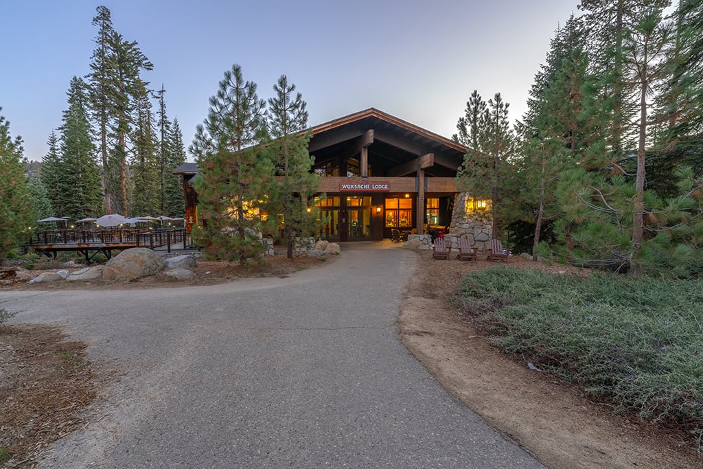
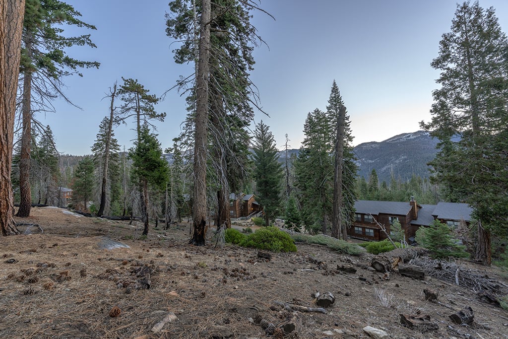
If you wish to overnight at a historic brick-and-mortar establishment, here are several in-park lodging choices, all of which fill up super-fast during peak season. It’s best you make your room reservations as far ahead as possible prior to your arrival – even a year ahead. I stayed at Wuksachi Lodge during my autumn visit. If you stay there, I highly recommend a made-to-order pizza from the lodge’s Pizza Deck. You can eat it at the outdoor deck area or take it to go.

If pitching a tent or parking your RV beneath the stars is more your style, there are fourteen campgrounds in these two parks, including two open year-round.

Note: Sequoia and Kings Canyon National Parks are now cashless for fees, including entrance fees, backcountry permits, and campgrounds, as of May 21, 2025. Only credit/debit cards are accepted. The gift shops and dining establishments that I visited are self-checkout which also only accept credit/debit cards.
Even with only three days in these parks, you’ll be able to see a wide range of sights and engage in plenty of activities with the suggested three-day itinerary below.
Day 1 – Get Acquainted with The Big Trees
Many of the parks’ trails are short, easily-navigable, and some are accessible to wheelchairs and walkers. They are also extremely popular during the peak summer season. During my late October visit, I encountered crowds but I’ll wager they were fewer than in the summer. I also learned early mornings and evenings are the best times to wander these trails.
At Sequoia National Park, my two favorite trails for an introduction to giant sequoia trees, their environment, and their ecology, are the General Sherman Tree Trail (0.5 miles/0.72 kilometers), and the Big Trees Trail (0.7 miles/1.12 kilometers). These trails are located within the Giant Forest.

At Kings Canyon National Park, my favorite trail is the General Grant Tree Trail (0.3 miles/0.5 kilometers), where you’ll see the second largest tree in the world, by volume, dubbed “The Nation’s Christmas Tree.” This trail is located in Grant Grove.

Spaced along these trails are great informational signs with trivia and interesting material pertaining to the park. Do take the time to read these signs to learn more about sequoias and these two parks preserving and protecting them.

While in the Giant Forest, go visit the Giant Forest Museum. Converted from the historic Market building (yes, there used to be a market, huge parking lot, and cabins in this area), the museum is a great introduction to sequoia natural history. My visit coincided with the government shutdown, so the museum and visitor centers were closed.
Keep tabs of your time if you wish to visit all three of these trails during the same day. It’s 31.5 miles (51 kilometers) between the Giant Forest in Sequoia National Park and Grant Grove in Kings Canyon National Park. You’ll be driving the Generals Highway, a twisting road with no guardrails winding along the edge of the Sierra Nevada Mountains at speed limits between 25 mph-35 mph (40 kph-56 kph). It will take you about an hour to drive between these destinations, and you do not want to drive faster than the posted speed limits.
Day 2 – Moro Rock And Crescent Lake Trail
Every national park has an iconic, must-hike trail. At Sequoia National Park, there are two iconic trails, one of which is the Moro Rock Trail. A series of over 350 narrow cement steps carved into a granite dome will take you to a lofty height of 6,726 feet (2,050 meters) above sea level.

It might not be a hike to take if you have a fear of heights, but if you can overcome that vertiginous feeling, the entire trek upward is a heady experience with views of forest and granite domes to the east and the San Joaquin Valley and Great Western Divide to the west, including the tight curves of the Generals Highway below this dome.

And, it’s only 300 feet (91.4 meters) to reach the summit. While it’s not the most popular hike in the park (that award belongs to the General Sherman Tree Trail), it certainly is one of the most popular hikes in the park.
Getting to Moro Rock is easy along a narrow road accessed from the Giant Forest Museum. There’s a parking lot next to the trailhead steps. Morning and evenings are the best times to climb the trail, although sunset is a popular venue for watching and photographing sunset, so it might get a little crowded on the steps. Remember to always let those climbing up have the right-of-way.
Returning to your vehicle from Moro Rock, the parking lot exit directs you either back to the Giant Forest Museum, or onward to Crescent Meadow. Take the route to Crescent Meadow, one of the largest meadows in Sequoia National Park.
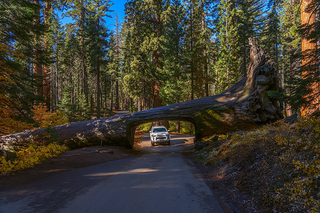
Along this road, you’ll pass such sequoia wonders as Buttress Tree, a fallen sequoia with twisted roots demonstrating the shallow root system of a sequoia tree; a cluster of giant sequoias collectively known as the Parker Group, named for the eight members of the family of Captain James Parker, the Acting Superintendent of Sequoia National Park from 1893-1894; and the famous Tunnel Log, carved by the young men of the Civilian Conservation Corps (CCC) from a fallen sequoia tree.

The Crescent Meadow Trail is an easy-to-moderate 1.4-mile (2.3-kilometer) hike along a partially-paved loop trail around the meadow. While on this trail, you’ll have the option of a 0.5-mile (0.72-kilometer) one-way side hike to Tharp’s Log, an 1861 cabin built in a downed sequoia tree by Hale Tharp, the first non-Native American to live in the Giant Forest.

There’s a picnic area, parking lot, and accessible restrooms at the trailhead for Crescent Meadow, so pack some water and snacks for a relaxing break after your hike.
These suggestions for Day 2 will take you through maybe half a day. You might wish to spend the remainder of your day driving along the Generals Highway, stopping at the overlooks and at any pullouts to view and photograph up close these sequoia giants, some of which are older than 2,000 years.
As the sun begins to wane and the sky darkens along the highway, find someplace to view and photograph the sunset. I found a large pullout near the Big Baldy Trailhead, about two miles (3.2 kilometers) southeast of the Kings Canyon Overlook for some great sunset shots.

Day 3 – Congress Trail and A Beetle Rock Sunset
The trailhead for this hike is accessed along the way down the paved General Sherman Tree Trail. This 2.7-mile (4.34-kilometer) roundtrip lollipop-shaped hike is less-visited than the General Sherman Tree Trail and bears the distinction of having the most clusters of sequoia trees on such a short trail. Along this trail, you will view the Congressionally-named Senate and House Trees as well as neck-craning monarch sequoias such as the President, Chief Sequoyah, and McKinley trees.

Take your time and get plenty of selfies with these huge trees. People are great scale and reference for comparison to these sequoia giants.

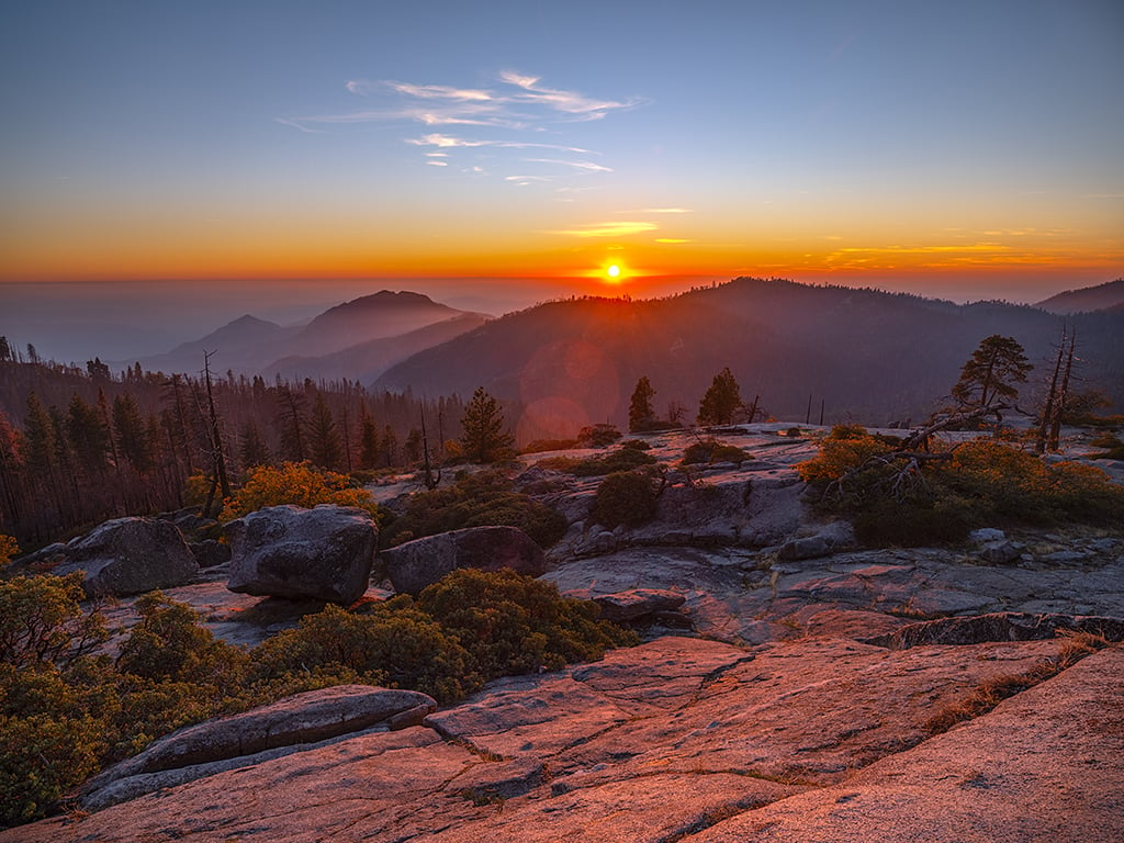
On your final day in the parks, find a new place to view and photograph the sunset. At Sequoia National Park, Moro Rock is a popular place, but my favorite area is Beetle Rock, across the highway from the Giant Forest Museum. Standing upon the rounded granite of this location named after the discovery of a new beetle species, you’ll experience a colorful sunset while viewing the park’s western edge and the San Joaquin Valley below. Beetle Rock is a short walk from the Giant Forest Museum parking lot, and there’s plenty of room to choose the best spot for a sunset on this granodiorite dome, which is a part of the Sierra Nevada Batholith.

When To Visit
When is the best time to visit Sequoia and Kings Canyon? Summer means great weather but also plenty of crowds. Everything should be open during the summertime.
During the fall, the weather will be more changeable but on average, still nice. Mornings and evenings will be cooler, and the air will be crisp during the day. You might encounter a little snow, and perhaps some roads will be closed. If you enjoy “leaf peeping,” these parks provide patches of fall color along the trails and the Generals Highway. There will still be people visiting, but nowhere near the summer crowd numbers.

In winter, the pace is slower, the crowds are gone, and a quiet peace settles upon the landscape. Snow occurs in the sequoia groves and rain falls in the foothills. Tire chains are required (even if you pilot a four-wheel-drive vehicle) and parts of the parks may close due to the weather. Bring your snowshoes, cross-country skis, or sleds for winter fun.
During the springtime, you may see some late-season snowstorms in the upper elevations (so make sure you have your tire chains handy), but the foothills will be painted with wildflower blooms. Mornings and evenings will still be chilly in the spring. Pack a mix of warm- and cold-weather clothing along with your raingear.
Side Trip
After your three-day stay in these parks, if you have time for a side trip, Yosemite National Park is about 4 hours’ drive north. Depending upon your departure time, you can easily spend a half or full day exploring Yosemite Valley. You might even decide to splurge and reserve a room at the historic Ahwahnee Hotel. Visit during autumn to view the explosion of fall foliage colors.

Note: By the time this article goes to print, the 2025 government shutdown may have ended. If not, Sequoia and Kings Canyon National Parks remain open during the shutdown, but campgrounds, visitor centers, the Giant Forest Museum, and other NPS facilities are closed.
Stories about:
Story Categories:
A copy of National Parks Traveler's financial statements may be obtained by sending a stamped, self-addressed envelope to: National Parks Traveler, P.O. Box 980452, Park City, Utah 84098. National Parks Traveler was formed in the state of Utah for the purpose of informing and educating about national parks and protected areas.
Residents of the following states may obtain a copy of our financial and additional information as stated below:
- Florida: A COPY OF THE OFFICIAL REGISTRATION AND FINANCIAL INFORMATION FOR NATIONAL PARKS TRAVELER, (REGISTRATION NO. CH 51659), MAY BE OBTAINED FROM THE DIVISION OF CONSUMER SERVICES BY CALLING 800-435-7352 OR VISITING THEIR WEBSITE. REGISTRATION DOES NOT IMPLY ENDORSEMENT, APPROVAL, OR RECOMMENDATION BY THE STATE.
- Georgia: A full and fair description of the programs and financial statement summary of National Parks Traveler is available upon request at the office and phone number indicated above.
- Maryland: Documents and information submitted under the Maryland Solicitations Act are also available, for the cost of postage and copies, from the Secretary of State, State House, Annapolis, MD 21401 (410-974-5534).
- North Carolina: Financial information about this organization and a copy of its license are available from the State Solicitation Licensing Branch at 888-830-4989 or 919-807-2214. The license is not an endorsement by the State.
- Pennsylvania: The official registration and financial information of National Parks Traveler may be obtained from the Pennsylvania Department of State by calling 800-732-0999. Registration does not imply endorsement.
- Virginia: Financial statements are available from the Virginia Department of Agriculture and Consumer Services, 102 Governor Street, Richmond, Virginia 23219.
- Washington: National Parks Traveler is registered with Washington State’s Charities Program as required by law and additional information is available by calling 800-332-4483 or visiting www.sos.wa.gov/charities, or on file at Charities Division, Office of the Secretary of State, State of Washington, Olympia, WA 98504.
INN Member

The easiest way to explore RV-friendly National Park campgrounds.

Here’s the definitive guide to National Park System campgrounds where RVers can park their rigs.
Our app is packed with RVing- specific details on more than 250 campgrounds in more than 70 national parks.
You’ll also find stories about RVing in the parks, tips helpful if you’ve just recently become an RVer, and useful planning suggestions.
