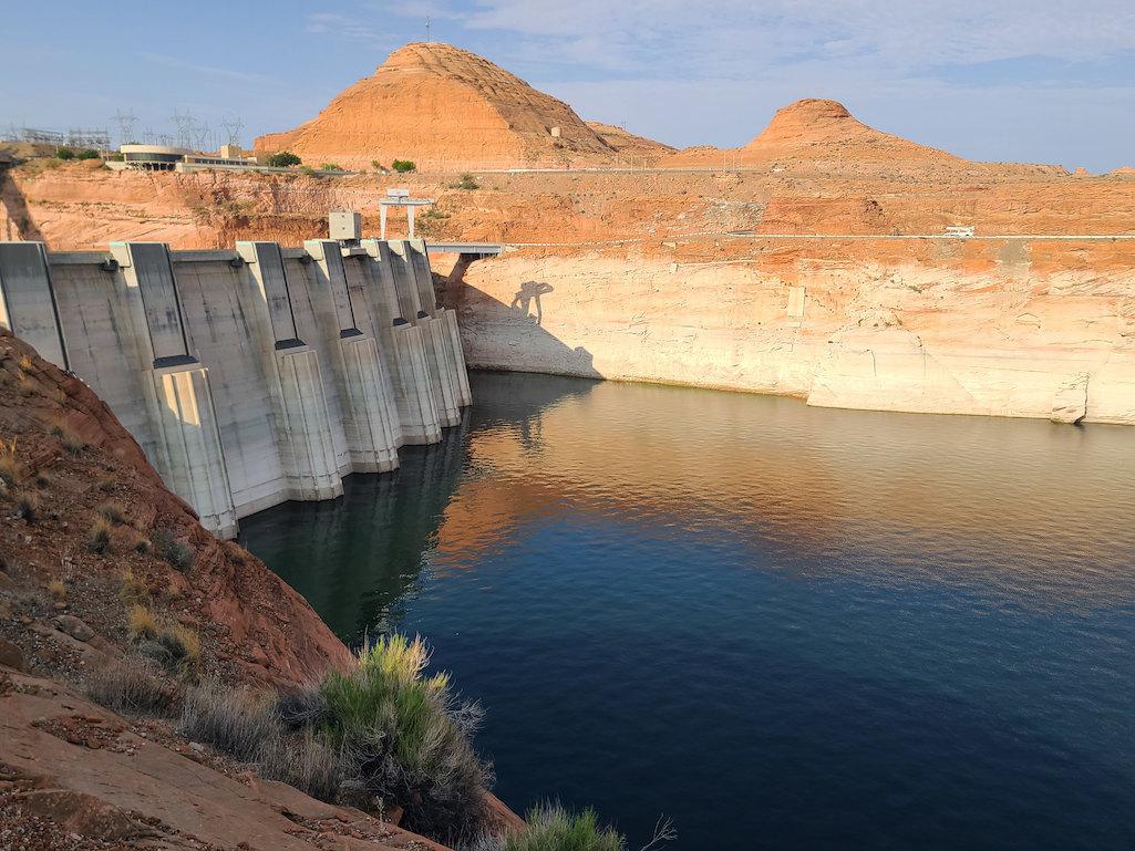
Dropping levels at Lake Powell are forcing a reduction in outflows from the Glen Canyon Dam/BuRec photo from August 2021. The white on the sandstone reflects where the water level once was.
Continued declines in runoff into the Colorado River are forcing federal officials to alter releases from Glen Canyon Dam and leading to a year-long closure of the Dangling Rope Marina at Lake Powell in Glen Canyon National Recreation Area.
In a bid to keep the hydroelectric generating plant in the dam operational, the U.S. Bureau of Reclamation has adjusted the monthly releases from Lake Powell to hold back 350,000 acre-feet of water each month from January to April when inflows to the reservoir are low.
The same amount of water will be sent downstream to Lake Mead between June and September after spring runoff, the agency said.
“Under the Drought Response Operations Agreement, making these monthly operational adjustments at Glen Canyon Dam is essential to protect Lake Powell from dropping to critically low elevation levels in the weeks and months ahead,” said BuRec's Upper Colorado Basin Regional director, Wayne Pullan. “Although the basin had substantial snowstorms in December, we don’t know what lies ahead and must do all we can now to protect Lake Powell’s elevation.”
The modified release pattern was put into action after BuRec staff met with basin partners including the basin states, tribes, federal agencies, non-governmental organizations and water managers to discuss the purpose and need to shift the delivery schedule of water.
According to a BuRec release, the 2022 water year got off to a promising start in the Colorado River Basin with a wetter-than-normal October, but it was followed by the second-driest November on record that resulted in a loss of 1.5 million acre-feet of inflow for Lake Powell compared to the previous month’s projections. December projections showed the reservoir dropping below the target elevation of 3,525 feet as early as February 2022, the agency said. As defined in the Drought Response Operations Agreement, the target elevation provides a sufficient buffer to allow for response actions to prevent Lake Powell from dropping below the minimum power pool elevation of 3,490 feet, the lowest elevation that Glen Canyon Dam can generate hydropower.

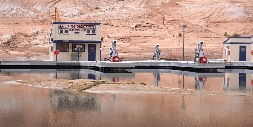
The Dangling Rope Marina on Lake Powell will not open this year/NPS file
Meanwhile, Glen Canyon NRA officials announced Monday that the Dangling Rope Marina in the southern end of Lake Powell will not open this year.
Due to dropping reservoir levels, park and concessioner staff are removing marina components from the Dangling Rope location to ensure they do not become beached and inaccessible.
The park, in partnership with concessioner Aramark, is continuing to look for a way to provide mid-lake fuel service during the 2022 season. Available options are complicated by lake levels that continue to decline, inherent challenges associated with the infrastructure needed to power and operate a fuel system, and operational considerations related to safety, staffing, and resources. We will continue to provide updates as they become available.
Restoring visitor services at the Dangling Rope Marina remains a high priority for Glen Canyon National Recreation Area. The importance of this visitor use area is identified in the park’s General Management Plan. The park will continue to seek long-term solutions that maintain a mid-lake marina presence at low and high lake levels.
“Dangling Rope is part of the park’s comprehensive drought response efforts. We know Dangling Rope is important to our visitors and is also extremely important to the National Park Service and our operations,” said Glen Canyon Superintendent William Shott.
Dangling Rope Marina has been the only place to obtain boat fuel between the Wahweap area in South Lake Powell and the Bullfrog area in North Lake Powell, a distance of approximately 100 miles. Boaters should plan ahead for their needs. For boaters averaging 20-25 mph, the trip to Bullfrog from Wahweap takes at least four to five hours. Fuel remains available at Wahweap, Antelope Point, and Bullfrog Marinas.


Comments
Been there, docked there in 50 ' houseboat with big wave day making it difficult. Adjoining small California boater claimed we had his his boat, cracked his windshiel & he wanted paid for new one. Called marina SECURITY & SHE sided with us & he walked away. Dangling Rope is in the middle of NOWHERE.
While 2021 was a tough year, 2019, 2020 and so far this year ran/is running well above the 10 year average. It would appear that consumption rather than run off is the issue.
https://api.snowdata.info/co/charts/basinplotcrb22.gif
But you also have to consider how dry the soil has been and how much moisture is being sucked up by that...
Most that snowpack is in a riverbed within a few miles if not yards of its melting point. I don't think the snowmelt crosses a lot of dry soil to get to the Colorado River.
What?
https://cronkitenews.azpbs.org/2021/04/01/dry-soils-plague-colorado-rive...
That isn’t the case this year, as many parts of the Colorado River Basin are parched. By the time snow starts melting this spring and summer, less of it will make its way to the streams that supply cities and farmers across thousands of square miles.
https://www.coloradoriverdistrict.org/2021/04/april-2021-water-supply-fo...
Adding insult to injury, low soil moisture will adversely impact runoff. Models from the Colorado Basin River Forecast Center suggest the majority of the Upper Colorado River Basin has such low soil moisture that it will require up to 12 inches of water to reach saturation. This means that most of the snowpack is absorbing into the soils and not turning into runoff. With the sizable reservoir drawdowns from last year, very few reservoirs are likely to fill in the upcoming water year. This soil moisture deficit presents a significant challenge to refilling the Colorado River storage system, especially the lower, larger facilities, like Lakes Powell and Mead.
And there are more stories about the low soil moisture and its impact on runoff in the basin.
Kurt, you live in Utah, how much snow from the Wasatch or Uinita crosses dry ground before it hits a river? I know in Summit County CO, no mountain top is more than a few thousand feet to a stream or river. And, given the snowpack has been above average 3 of the last 4 years, how "parched" could it actually be?
ec, your ignorance is showing again. You owe Kurt an apology. Here are clips from a recent article in the Salt Lake Tribune (December 18, 2021) that you need to read:
Utah's mountain snowpack was looking pretty good in October, when the state got 2-3 times its normal rainfall. Salt Lake City totaled 3.49 inches; it averages 1.26 inches.
"We were ahead of schedule," David Church, the National Weather Service's science and operations officer in Salt Lake City, said. "But then we got into November, and we didn't have any [precipitation] for three or four weeks. That really set us back."
So did higher than average temperatures. According to the Utah Division of Water Resources, the average temperature from Nov. 15-Dec. 14 was 4.8 degrees above normal, causing some of the snowpack to melt.
According to Church, Utah hit a record-low snowpack from about Dec. 1-9. A storm on Dec. 9 got the snowpack up to just below the 10th percentile. This week's storms took the state to about the 20th percentile. (The 50th percentile would be average.)
"It's kind of a bummer, because we had a decent amount of upper elevation snow in October. But we lost a lot of it to sunshine," Steenburgh said. "So it's kind of like a reset, where we've just started to build up the snowpack again, starting in early December."
It's not all bad news: Soil moisture is 16% above average for this time of year. If that holds, it could mean more mountain runoff in reservoirs come spring and summer.
"Last year, we had record dry soils going into the winter," Church said. "And then we put a below-average snowpack on top of that. So when that melted off, a large amount of that runoff just went into the soil."
"Basically, the soil sucked up maybe about half of that moisture instead of it running off into the reservoirs," he continued. "That was key for the drought to continue to worsen."
Because of improved soil moisture, "We're in a much better place than we were last year," Church said. "Whatever snowpack we do build up this year will be much more efficient as it runs off the next year -- running into the reservoirs and not just soaking into the soil."
"From a water perspective, building snowpack in the mountains is one of the most important things," Church said. "In a way, it acts like a reservoir for us -- a frozen one."
But that doesn't mean that Utah's valleys need to be buried under snow over and over again through the winter. "If it just rains in the valleys and then we keep a lot of good snowpack in the mountains, that would be fine," Church said.
"Mountain snow and valley rain works," Steenburgh, who goes by "Professor Powder" on Twitter, said with a laugh. "I like snow in the yard sometimes. But a 5,000-foot snow level means less shoveling and less wear-and-tear on my back, but I still get to go skiing. That's kind of the dream scenario."
Yes Lee, 2021 was a bad year, as I mentioned 2019,2020 and this year are not.