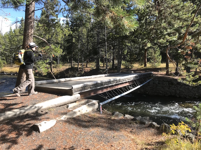
Your hike to Mallard Lake starts with a footbridge that takes you across the Firehole River/Kurt Repanshek
Though I've been visiting Yellowstone National Park for a few decades and hiked many of the park's trails, in truth I've only scratched the surface of the backcountry paths that wind through this incredible landscape. So on my latest trip I packed four guidebooks and three maps with plans to discover a new one. And the one I did was practically out the door of my cabin.
How I had overlooked the trail to Mallard Lake all these years is a bit of a mystery. No doubt, the fact that it leaves the Upper Geyser Basin, a fascinating place that draws Yellowstone visitors back again and again and again and holds them there, had something to do with it. But with the trailhead near Old Faithful Lodge and the destination a shimmering backcountry of roughly 30 acres, I should have hiked it long ago.

Early on, the trail carries you through a lodgepole forest/Kurt Repanshek
The trail can either be tackled as an out-and-back, 7-mile hike, or made into a longer, 11-mile loop by continuing from the lake down the Mallard Creek Trail, which heads 4.2 miles to the northwest and ties into the Powerline Trail. The Powerline Trail then heads back south about 4 more miles to the Old Faithful Inn. For those just getting into backpacking, or who are short on time, there are three backcountry campsites on the shore of Mallard Lake that can be reserved and offer a quick and easy overnight jaunt. Site OB3 offers the most solitude, as it's at the end of a trail that goes partway around the lake. (Traveler note: No campfires are allowed at these sites.)
The Mallard Lake Trail trailhead is at the southern end of the loops of cabins associated with the Old Faithful Lodge. It quickly takes you across a footbridge spanning the Firehole River. If you leave the trail and follow the river upstream to the right you'll come upon a small collection of hot springs (Pipeline Hot Springs). Back on the main trail, you'll walk through a fairly mature lodgepole pine forest. Soon, however, you'll leave the forest, cross a small creek, and head uphill in a drainage cut through a rhyolite landscape, a signature of Yellowstone's volcanic underpinnings.
While you'll climb about 900 feet in elevation going up to the lake, it's an easy, gradual climb, not a leg- or lung-buster. The trailbed along the way varies from cinders to pine needles and dirt to loose talus rubble. Just before the final, downhill, approach to the lake, you'll come to a junction with the Mallard Creek Trail.
The early fall day we visited the lake it held a few Canada geese and maybe two dozen mergansers or other duck species. While the lake was determined in 1919 to be barren of fish, according to the National Park Service, it later was planted with Eastern brook trout.
If there's a downside to this ramble, it's that you never entirely escape road noise coming from the Old Faithful area.
If You Go:
Trailhead: South end of cabins associated with Old Faithful Lodge
Distance: 7 miles to lake and back, 11 miles following Mallard Creek Trail to Powerline Trail and back to Old Faithful Inn
Difficulty: Easy
Maps: Trails Illustrated Map 302, Old Faithful
Tips: We didn't see any wildlife other than waterfowl, but it's always good to travel with bear spray in Yellowstone's backcountry.

Mallard Lake on an early fall day that dropped some rain and snow along the trail/Kurt Repanshek
Stories about:
Story Categories:
A copy of National Parks Traveler's financial statements may be obtained by sending a stamped, self-addressed envelope to: National Parks Traveler, P.O. Box 980452, Park City, Utah 84098. National Parks Traveler was formed in the state of Utah for the purpose of informing and educating about national parks and protected areas.
Residents of the following states may obtain a copy of our financial and additional information as stated below:
- Florida: A COPY OF THE OFFICIAL REGISTRATION AND FINANCIAL INFORMATION FOR NATIONAL PARKS TRAVELER, (REGISTRATION NO. CH 51659), MAY BE OBTAINED FROM THE DIVISION OF CONSUMER SERVICES BY CALLING 800-435-7352 OR VISITING THEIR WEBSITE. REGISTRATION DOES NOT IMPLY ENDORSEMENT, APPROVAL, OR RECOMMENDATION BY THE STATE.
- Georgia: A full and fair description of the programs and financial statement summary of National Parks Traveler is available upon request at the office and phone number indicated above.
- Maryland: Documents and information submitted under the Maryland Solicitations Act are also available, for the cost of postage and copies, from the Secretary of State, State House, Annapolis, MD 21401 (410-974-5534).
- North Carolina: Financial information about this organization and a copy of its license are available from the State Solicitation Licensing Branch at 888-830-4989 or 919-807-2214. The license is not an endorsement by the State.
- Pennsylvania: The official registration and financial information of National Parks Traveler may be obtained from the Pennsylvania Department of State by calling 800-732-0999. Registration does not imply endorsement.
- Virginia: Financial statements are available from the Virginia Department of Agriculture and Consumer Services, 102 Governor Street, Richmond, Virginia 23219.
- Washington: National Parks Traveler is registered with Washington State’s Charities Program as required by law and additional information is available by calling 800-332-4483 or visiting www.sos.wa.gov/charities, or on file at Charities Division, Office of the Secretary of State, State of Washington, Olympia, WA 98504.

National parks and their natural resources belong to you. The National Parks Traveler works to ensure you know how these essential places are being cared for.
Sign Up For Our Weekly Newsletter
Unsubscribe at any time.
INN Member

The easiest way to explore RV-friendly National Park campgrounds.

Here’s the definitive guide to National Park System campgrounds where RVers can park their rigs.
Our app is packed with RVing- specific details on more than 250 campgrounds in more than 70 national parks.
You’ll also find stories about RVing in the parks, tips helpful if you’ve just recently become an RVer, and useful planning suggestions.

Comments
Wish I was There! Here is a link to a map for those that like the visual of a map; http://www.trailguidesyellowstone.com/yellowstone_hikes/mallard_lake_tra...