
Glacier National Park is a hiker's paradise, as this National Park Service shot of Mount Gould clearly shows. But where should you head? Jeff Doran has some suggestions.
Editor's note: Back in November we told you about Jeff Doran's efforts to build a website focused on hiking in Glacier National Park. That site offers a rundown on more than 60 hikes in Glacier. Below Mr. Doran shares some of his favorite day hikes with fellow national park travelers.
"Give a month at least to this precious reserve. The time will not be taken from the sum of your life. Instead of shortening, it will indefinitely lengthen it and make you truly immortal. Nevermore will time seem short or long, and cares will never again fall heavily on you, but gently and kindly as gifts from heaven." - John Muir on his visit to Glacier in the early 1890s
Encompassing more than a million acres, Glacier National Park in northwestern Montana is home to some of the most beautiful alpine meadows, lakes, pristine forests, rugged peaks and glacially-carved valleys in the world. Its diverse habitats support nearly 70 species of mammals, including grizzly bears, black bears, mountain goats, bighorn sheep, moose, wolverines, gray wolves and mountain lions.
With more than 740 miles of trails that lead to some of the most spectacular scenery on the planet, Glacier is also a hiker's paradise. Considering its massive size, most people divide the park into sections in order to focus on one or two areas at a time. The four most popular areas in the park are West Glacier / Lake McDonald, Two Medicine, Logan Pass, and Many Glacier. The following are some suggestions for day hikes in each of these areas.
West Glacier / Lake McDonald
One of the things that makes hiking in Glacier unique are its two Swiss-style backcountry chalets: Granite Park and Sperry.
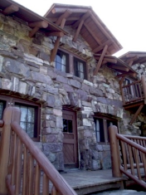
Sperry Chalet. Jeff Doran photo.
The Granite Park Chalet can be reached from Logan Pass or a 4.2 mile climb from The Loop area on the west side of the park. However, one of the most popular destinations west of the Continental Divide is Sperry Chalet. The 6.1-mile hike from the Lake McDonald Lodge passes through Glacier Basin where hikers view several waterfalls flowing hundreds of feet down the cliff walls that surround the alpine meadow.
At the chalet hikers have the opportunity to purchase a lunch at the dining room, or, stay overnight at the historic lodge. From the same trailhead is the hike that leads to the historic Mt. Brown Fire Lookout. The trail climbs 4250 feet in only 5 miles, making it one of the toughest day hikes in the park. The elevation gain is similar to the amount gained on many of the trails leading to the summits of 14,000-foot peaks in Colorado. However, at a much lower elevation, hikers will have far more oxygen to breathe. From the lookout the views into the heart of Glacier are simply amazing.
Two Medicine
Although not quite as popular as some of the other areas of Glacier, the Two Medicine Valley in the southeast corner of the park still offers some incredibly beautiful scenery. One of the best hikes in this area leads to Scenic Point. This rock outcropping, which sits above an alpine tundra meadow, offers panoramic views of much of the entire Two Medicine Valley. On a clear day you can even see the Sweet Grass Hills rising above the Great Plains 90 miles away!
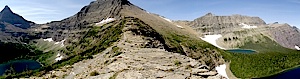
A panoramic view of Pitamakan Pass. Jeff Doran photo.
The most well-known backcountry hike in Two Medicine is Dawson Pass. Although this route usually gets all the attention, I think the views from Pitamakan Pass are much more dramatic. From the knife-edge ridge you can see five cobalt-blue lakes on either side of you. Can’t decide on which to hike? The two passes can be combined to create one epic day on the trail.
Many Glacier
One of the most popular destinations in the park is Many Glacier. Hikes such as Iceberg Lake and Grinnell Glacier get most of the attention; however, there are two other destinations that shouldn’t be overlooked, especially if you’re seeking a degree of solitude in this valley. One of those is Ptarmigan Tunnel.
The highlight of this hike is passing through a 240-foot tunnel that cuts a hole through Ptarmigan Wall. The tunnel was built by the Civilian Conservation Corp in the 1930's so that visitors on horseback could pass over into the remote Belly River area. After hiking all day in the Many Glacier Valley, walking to the other side of the tunnel is like walking into another world. The views from the other side are simply stunning.
The other destination, Cracker Lake, has to be one of the most beautiful lakes in the world. It has the most beautiful turquoise color you could ever imagine. If it were possible to ignore the magnificent scenery of the surrounding mountains it would still be well worth the 12.6-mile roundtrip hike, just to see the amazing color of this lake. Cracker Lake’s deep shade of turquoise is the result of light refraction through its suspended load of glacial silt.
Logan Pass
To see the best of what Glacier National Park has to offer you have to go deep into the high country. One of the most popular hikes in the park is the Highline Trail. In fact, this world famous hike should be on the bucket list of any self respecting hiker.
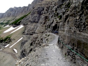
The "ledge" along the Highline Trail. Jeff Doran photo.
The views, the wildlife and the wildflowers, all combine to make this a hike you'll remember the rest of your life. From Logan Pass, high adventure awaits right from the start. Just beyond the trailhead hikers are forced to cross over a six-foot ledge for roughly a quarter of a mile. One false move and your next stop is on the pavement of the Going-To-The-Sun Road - more than one hundred feet below.
But don’t let this deter you. Ninety-nine percent of the Highline passes through open country, so there's never any dull scenery on this hike. The trail is also famous for wildlife, especially bighorn sheep and mountain goats, which are frequently seen just off the side of the trail.
Just a notch below the Highline Trail on the “awesome meter”, but far less crowded, is Piegan Pass. The trail offers mind-blowing views of mountains, glaciers, alpine meadows and an up-close view of the Garden Wall, a glacially-carved arête that marks the Continental Divide.
Near Piegan Pass, and one of my absolute favorite areas in Glacier, is Preston Park. In the early summer, after the snow melts, this incredibly beautiful alpine meadow becomes a carpet of wildflowers.
For more information on these hikes, and others throughout the park, please visit Hiking In Glacier.
Story Categories:
A copy of National Parks Traveler's financial statements may be obtained by sending a stamped, self-addressed envelope to: National Parks Traveler, P.O. Box 980452, Park City, Utah 84098. National Parks Traveler was formed in the state of Utah for the purpose of informing and educating about national parks and protected areas.
Residents of the following states may obtain a copy of our financial and additional information as stated below:
- Florida: A COPY OF THE OFFICIAL REGISTRATION AND FINANCIAL INFORMATION FOR NATIONAL PARKS TRAVELER, (REGISTRATION NO. CH 51659), MAY BE OBTAINED FROM THE DIVISION OF CONSUMER SERVICES BY CALLING 800-435-7352 OR VISITING THEIR WEBSITE. REGISTRATION DOES NOT IMPLY ENDORSEMENT, APPROVAL, OR RECOMMENDATION BY THE STATE.
- Georgia: A full and fair description of the programs and financial statement summary of National Parks Traveler is available upon request at the office and phone number indicated above.
- Maryland: Documents and information submitted under the Maryland Solicitations Act are also available, for the cost of postage and copies, from the Secretary of State, State House, Annapolis, MD 21401 (410-974-5534).
- North Carolina: Financial information about this organization and a copy of its license are available from the State Solicitation Licensing Branch at 888-830-4989 or 919-807-2214. The license is not an endorsement by the State.
- Pennsylvania: The official registration and financial information of National Parks Traveler may be obtained from the Pennsylvania Department of State by calling 800-732-0999. Registration does not imply endorsement.
- Virginia: Financial statements are available from the Virginia Department of Agriculture and Consumer Services, 102 Governor Street, Richmond, Virginia 23219.
- Washington: National Parks Traveler is registered with Washington State’s Charities Program as required by law and additional information is available by calling 800-332-4483 or visiting www.sos.wa.gov/charities, or on file at Charities Division, Office of the Secretary of State, State of Washington, Olympia, WA 98504.

National parks and their natural resources belong to you. The National Parks Traveler works to ensure you know how these essential places are being cared for.
Sign Up For Our Weekly Newsletter
Unsubscribe at any time.
INN Member

The easiest way to explore RV-friendly National Park campgrounds.

Here’s the definitive guide to National Park System campgrounds where RVers can park their rigs.
Our app is packed with RVing- specific details on more than 250 campgrounds in more than 70 national parks.
You’ll also find stories about RVing in the parks, tips helpful if you’ve just recently become an RVer, and useful planning suggestions.

Comments
Can you recomend a few easy walks for us to take as a group Mom is in her mid 70's, two 50 someting sisters and two nieces in their 20's? Thanks!
Lori, here's what Jeff suggests:
There are several trails in Glacier that pass through or lead to beautiful locations. Running Eagle Falls in Two Medicine is completely flat and leads to one of the better falls in the park. Paradise Point in Two Medicine is another great hike leading to a shoreline view of Two Medicine Lake.
A little bit longer, but also flat as a pancake is the Swiftcurrent Lake Nature Trail in Many Glacier. This is one of my favorite hikes in the park.
If you're not afraid of heights, one of the most scenic trails in America is the Highline Trail at Logan Pass. The trail traverses along a sharp drop-off for about a quarter of a mile, and is roughly 4 or 5 feet in width during this section. It's not exceedingly dangerous if weather conditions are good, you take your time, and use the hand-hold along the rock wall (and not afraid of heights). You could take this hike on a ranger-led hike as well. The trail is pretty flat for the first 2.5 miles.
If you don't like the idea of hiking along a cliff, you can go to the other side of the pass and hike up to Hidden Lake Overlook. This is another outstanding hike, but requires some climbing on a boardwalk trail. Although it's a little steep, it's relatively short at 2.7 miles round-trip.
On the west side of the park is the Trail of the Cedars and the Johns Lake Loop. Both are flat hikes offering a variety of beautiful destinations.
Here is a list of trails ranked by difficulty, if this will help:
http://www.hikinginglacier.com/hiking-glacier-national-park.htm
If not hiking on a ranger led hike, I highly recommend hiking in a group of at least two other people - given this is grizzly bear country. You should also carry bear spray (and know how to use), and make lots of noise.
Thanks!
I agree with the comments in the Two Med area. I did the Dawson-Pitamakan loop on a beautiful day and it has to be one of my all time favotite hikes. Its a tough one at around 18 miles (without boat shuttle) with around 3,000' of elevation change but its worth every bit of it. You'll remember the stretch from Dawson to Pitamakan the rest of your life.