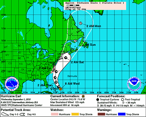
Five-day forecast cone and windspeeds forecast for Hurricane Earl at 8:00 a.m. EDT, September 1. NOAA.
Hurricane Earl, a large and powerful storm, remains on track to impact the national parks of North Carolina's Outer Banks region. The three national parks in the storm's crosshairs Cape Lookout National Seashore, Cape Hatteras National Seashore, and Wright Brothers National Memorial -- will continue to implement emergency plans for protecting people and property. Visitor evacuations are underway, facilities are being closed on a staggered schedule, and by 5:00 p.m. today the Outer Banks parks will be closed until further notice.
At nearby Roanoke Island, Fort Raleigh National Historic Site occupies a relatively protected location and has no seashore beaches. Emergency managers do not anticipate serious impacts there, but the park's visitor center will close at 5:00 p.m. today.
The post-storm assessments for the Outer Banks parks is scheduled for Friday, depending on the timing of the storm's arrival and its duration. Until the parks are re-opened, the seashore beaches are presumed to be unsafe for recreational use due to rough surf, dangerous rip currents, and ocean overwash. Off-road vehicle use is temporarily prohibited in the parks until conditions are once again deemed safe for ORV activity.
At 8:00 a.m. EDT, Hurricane Earl was located at 24.5 N 71.6 W (780 miles SSE of Cape Hatteras, North Carolina) and moving NW (310 degrees) at about 16 miles per hour. Bearing maximum sustained winds of 125 mph, and generating hurricane-force winds across a zone several hundred miles wide, the Category 3 storm is fluctuating in intensity (which is quite normal) and can be expected to attain Category 4 strength at times. This is a serious storm by any reasonable measure
Forecasters are confident that Earl's track, which has shifted westward a bit during the past few days, will bring it close to the Outer Banks and then northeastward along the Atlantic Coast before it eventually moves away from the mainland. However, they can't know exactly what path the storm will take over the next few days. Much depends on the storm's location relative to a trough of low pressure lying to the west. Where Earl will go, how strong it may become, and how heavily it will impact the Atlantic Coast depends a good deal on the trough's position as the hurricane nears the mainland.
The storm's effects will be apparent in the Outer Banks parks today, but won't reach their maximum extent until late Thursday.
Hurricanes are a familiar feature of Outer Banks weather. On average, the region gets brushed by a powerful storm every two or three years and takes a direct hit every seven or eight years. In July 2008, Hurricane Cristobal brought winds of 50 mph to the region.
Emergency planners at Gateway National Recreation Area in New York/New Jersey and Cape Cod National Seashore in Massachusetts are watching this storm with growing concern. The 5-day forecast cone and estimates of associated maximum windspeeds strongly suggest that these parks, and perhaps those in the Mid-Atlantic, may be in for a rough patch by Friday.
Story Categories:
A copy of National Parks Traveler's financial statements may be obtained by sending a stamped, self-addressed envelope to: National Parks Traveler, P.O. Box 980452, Park City, Utah 84098. National Parks Traveler was formed in the state of Utah for the purpose of informing and educating about national parks and protected areas.
Residents of the following states may obtain a copy of our financial and additional information as stated below:
- Florida: A COPY OF THE OFFICIAL REGISTRATION AND FINANCIAL INFORMATION FOR NATIONAL PARKS TRAVELER, (REGISTRATION NO. CH 51659), MAY BE OBTAINED FROM THE DIVISION OF CONSUMER SERVICES BY CALLING 800-435-7352 OR VISITING THEIR WEBSITE. REGISTRATION DOES NOT IMPLY ENDORSEMENT, APPROVAL, OR RECOMMENDATION BY THE STATE.
- Georgia: A full and fair description of the programs and financial statement summary of National Parks Traveler is available upon request at the office and phone number indicated above.
- Maryland: Documents and information submitted under the Maryland Solicitations Act are also available, for the cost of postage and copies, from the Secretary of State, State House, Annapolis, MD 21401 (410-974-5534).
- North Carolina: Financial information about this organization and a copy of its license are available from the State Solicitation Licensing Branch at 888-830-4989 or 919-807-2214. The license is not an endorsement by the State.
- Pennsylvania: The official registration and financial information of National Parks Traveler may be obtained from the Pennsylvania Department of State by calling 800-732-0999. Registration does not imply endorsement.
- Virginia: Financial statements are available from the Virginia Department of Agriculture and Consumer Services, 102 Governor Street, Richmond, Virginia 23219.
- Washington: National Parks Traveler is registered with Washington State’s Charities Program as required by law and additional information is available by calling 800-332-4483 or visiting www.sos.wa.gov/charities, or on file at Charities Division, Office of the Secretary of State, State of Washington, Olympia, WA 98504.
INN Member

The easiest way to explore RV-friendly National Park campgrounds.

Here’s the definitive guide to National Park System campgrounds where RVers can park their rigs.
Our app is packed with RVing- specific details on more than 250 campgrounds in more than 70 national parks.
You’ll also find stories about RVing in the parks, tips helpful if you’ve just recently become an RVer, and useful planning suggestions.

Comments
Why is it that when there is an oil spill in the gulf the people run to relocate turtle nests, but when a hurricane strikes no one mentions the fact that roughly 100 nests are left to surely perish? Ironic isn't it!
Sam, I think the big difference is that the oil spill was caused by man, while hurricanes are part of nature.
That excuse is used only when it benefits you. Please see Cape Hatteras NPS killing of nature by the hundereds to protect a few birds? Sound familiar. This is so typical to use a statement or science that fits the moment or your cause.
"Sam, I think the big difference is that the oil spill was caused by man, while hurricanes are part of nature."
Really? I thought the number one perogative was to propogate turtles so there is more of them, regarless of the cause. Isn't that why they are closing the beach, to allow turtles to propogate? If they(turtle eggs) can be moved in other places, why not in Hatteras? There's going to be a whole lot of dead turtle eggs in Hatty because they weren't moved in anticipation of this hurricane. That really helped(not moving the eggs) out scientists, thank's a lot. Seem's like turtle blood is on the hands of the scientists.
Darren I hope you understand I am on your side... and that the deaths of these turtles is another example of the DOI, NPS and the Enviro's Playing GOD by picking and choosing what survives and why.
Is the deaths of hundereds of predators that are trying to eat as nature intended a "Natural" Event? The enviromentalist will have you believe they are trying to save a plover by killing a fox (or dozens of them). When in reality most of these birds die at the claws of a ghost crab.
Back to the point. The fact that someone (NPS, Enviro, President Obama, DOI, etc) made the decision to let thousands of turtles die at the expense of a "Natural Event" and waste hundereds of man hours to set up these closures and netting around each of the hundered or so nests that remained. they also will not be required to account for all of the materials (netting, string, posts, signage) that are now introduced to the environment.
Enviros will always win because humans that go against their asperations are not cute and cuddly and if they don't they will do as Mr Lee did in Maryland @ discovery.
Seems illogical.. if a species is truely endangered, any help to save potential hatchlings seems prudent. Perhaps there is more involved with this philosphy? If the resource was rapidly recovering, there is less opportunity to leverage concern for them in other areas, such as reducing the use of the Park. Sounds cynical but seems to be the most obvious motive..
How appropriate that on the day that the Hurricane is striking our beautiful Recreation Area... the Islanders are launching their response to the Environmental (lawyers) Focus Groups. The only ones that gain in this whole deal are the lawyer, after they sue the US Gov... and win on pseudo-science... unproven studies and a pool of SPIN MONEY... they get to collect from the same Gov that they beat in court.
Finally, reasonable voices of the residents are going to heard. for all you Social Media types... check out the words of the People-Residents and Business folks of the island and the truth behind what's happening there.
http://www.facebook.com/video/video.php?v=593797982139&ref=mf
Remember, remember, remember.... the only people making money on this are the LAWYERS!!!! No birds, no turtles, no residents....they are losing their lives and lively hoods.
It is not about lawyers making money but rather a few individuals who usurped a National Park under the pretence of “recreation” so they can continue their business of catering to a special interest group of visitors (ORV users). Regulations that regulate vehicle use in this National Park are overdue and have been inadequate for a long time.
The fishing/ORV community is more concerned with finding fault with NPS policies than protecting wildlife as demonstrated by their fishing activities, such as specific targeting of fish for catch and release that are prohibited from landing by both state and federal regulations and the tens of thousand of bait fish to catch them with.
Hey SS1 did you forget that the suit filed was finding fault in the NPS? They also walked away with 100,000 in the lawyer pockets. I believe you need more research before making comments. If access to the National parks means special interest then yes we are....
Matt
And how much did your side walk away with the first time the Judge ruled in your favor over critical habitat? Do you expect Holland and Knight (DC law firm hired by CAPA) to work for ORV access on your behalf for free? Are there any CHNS policies that concern resource protection that you support?
If the NP beach is an ORV route with cars bumper to bumper it is of no concern to me if I can walk there or not.
Hey SS1, Every heard about the 78 plan? You know, the one that was approved by everybody in 1978. It was sent up through the chain of command to Washington DC, only to get lost by the NPS. NPS has used the 78 plan's rules for guide lines for closures, speed limits, and protection for the animals for over 30 plus years. The problem now is that some people are trying to change the plan without allowing the locals and the people of the USA to have a say in the matter. They don't care about the animals, just that they could be used to closed the park for all humans. Check the real facts, not their half truths about Cape Hatteras. Check NPS own records about relocation verse letting nature happen. 50% by natural, 75% by human assistance. 25% more baby turtles into the wild if we help. What should we do? I like to save the sea turtles so they can be eaten by others in the world....
SS1. First of all it is not MY SIDE VERSUS YOURS. I simply stated a fact on that the LAWYERS only pick the low hanging fruit to partner up and file a suit.
Now as far as protections for species on the outerbanks. I firmly believe every entity needs protections of some sort or another, BUT when people claim the need for 1,000 meters to protect a bird only on Hatteras Island where all other areas that this bird breeds (in larger Numbers I might add) only require 200 meters. If there is real science to prove the 1,000 meters then I would like to see this implimented across the board in all breeding grounds. The same with turtles in Cape Hatteras they shut down the beach and just to the south they put a small cage over it.
My original point was in replying to this article is also to say the environmentalist movement only chooses the high profile easy targets. That was proven when they had one week plus warning to provide the "Endangered" helpless turtles by relocating the nests. Instead they did not give it a second thought because the Turtles served their purpose by closing the beaches.
Matt,
[Gratuitous remark deleted]
First, the NPS was allowed to, and did relocate nests in danger, that were 35 days into incubation. It doesn't matter what the "environmental movement" wanted, but is up to the state of North Carolina as to what could be relocated, or not.
Second, I don't know of any beaches were closed because of the nests in question. They just have four signs around them and allowed for plenty of access around the ones I observed. That said, by the looks of Earl, there wasn't a safe beach on which to relocate them.
Third, that's 200 meter buffers for pedestrians, not ORVs. There is a stipulation for private landowners to minimize buffers to prevent a taking (when the feds deprive a landowner the rights of their property), but it does not apply to federal lands.
Dan,
The "78 plan" was lost through lobbying by access "interests" to get it "lost". Superintendents who attempted to follow the letter of the plan anyway were also "lost" (read the history on Island Free Press). The only way left for persons concerned with protecting the species to compete with the DC influence was through the courts.
Protections prior to 2005 were token protections and did not actually protect anything.
Anonymous,
While it may seem "prudent" to the naive, there are many biological problems associated with nest relocation. Reduced hatch and emergence rates, distorted sex ratios and reduced fitness among them. The population is nowhere near the need for such actions (like the Kemps Ridley in the Gulf which was down to about 400 females).
The recovery plan calls for relocation as a management action of last resort. That requires certainty one cannot have, because in any given year, there's not a beach on Hatteras that cannot be productive.
The issues the recovery plan focuses on are those that can be controlled - ie human disturbance, fisheries interactions, etc.
Dan
You mean the 1978 Interim Draft ORV Plan. A plan that was not complet never finalized and not used. Different superintendents issued various Superintendent Orders that deviated from the plan when it resurfaced in 2002.
Your real turtle facts are in real dispute by real scientist.
"They don't care about the animals, just that they could be used to closed the park for all humans"
There in a nutshell is why there has not been any real dialogue with your side. You spout off emotional propaganda like you had a copy of some secrete environmental manifesto.
Matt,
" fact on that the LAWYERS only pick the low hanging fruit to partner up and file a suit"
What fact book does this come from? And remember your side has environmental lawyers also.
We environmentalists see a difference from continual nighttime driving year after year in, around and sometime over top of turtle nests for the entire season and natural disasters like a category 4 hurricanes. Unless you move all the turtle nests to the center of the maritime forest there is probably no safe place. It is a National Park not a commercial turtle hatchery.
There is room for compromise with driving restrictions and turtles, especially in the fall. Maybe now your side will actually try to compromise for a change. In any case driving a vehicle on the NP beach is not the only way to access the Park.
With resource protection concerning ESA birds I guess one shoe doesn't fit every situation. It also doesn't mean that tighter restriction is not needed in other places. The enabling legislation specifically mentions protecting unique flora and fauna over visitor’s convenience, which translates into tighter protection for Oystercatchers, Terns and Skimmers than on non-CHNS beaches.
I did not claim we did not have lawyers.
The difference you see in one (night time driving you mention specifically) and two (Catagory 4 Hurricane) is What????? Is it the same difference you see in daytime driving and a catagory 2 hurricane? My point here is that you state that you see a difference but never explain the difference. You see I mentioned that it was interesting that environmentalist will run down and rescue a turtle when the mainstream media is watching on the gulf coast (relocated them to Florida, much further than the maritime forest!!!), but will do nothing to rescue a turtle nest when no one is watching. even though these are the same animals that you environmentalist types kick and scream about keeping beaches closed to people with draconian measures such as overly large roped off areas compared to the rest of the east coast. Every other area that is not under the microscope of the NPS does it way differently and with more success and the only reason why Cape hatteras changed its ways is because of your enviro lawyers picking low hanging fruit.
As far as your comments on the ESA...
By enabling legislation do you mean the consent decree or the National parks version. No Matter. It still does not address the fact that each nesting pair of Plovers gets protection the size of an aircraft carrier only on this island and no where else in the world. Is this island so different that a person may get within 200 yards of this bird anywhere else they are protected and here they need 1000 yards? The only reason for this is to allow a bird who's mere existance on this island is a rarity (less than 100 birds have fledged in 20 years?) to be a poster child for eliminating humans from the beach (notice I say humans and not ORV's as the buffers are for all). Then you mention protecting Oystercatchers, Terns and Skimmers which even the state of North Carolina states need no extra protection. Just another way of keeping people off the beaches. People who go to the beach do not recreate in unique flora and fauna, they do so in SAND. After recreating in Cape Hatteras for over 20 years I can say with 100% confidence I have not harmed anything more than a Mosquito.
Question for all the environmentalist.
What do I tell my 5 year old son when he asks "Why cant we go that way on the beach (walking I might add)" and I reply "because there is a Plover bird nest 1000 yards past those signs" which gets this reaction "WOW that is ten football fields they must be really BIG BIRDS?"
Matt
Nothing gives me more pleasure than seeking children fish and hunt. I am 100% in favor of access to do these things in CHNS. I’m really sorry it has come to all this.
I think there is plenty of room for resource compromise with both turtles and birds. The ORV side leaders and spokespeople continue to thwart providing pedestrian access corridors at the waterline around resource closures, ask the presidents of North Carolina Beach Buggy Association and Cape Hatteras Anglers Club their thoughts on this. It appears to me they want to make a big deal out of pedestrian access only when they can attach it to ORV access. If you really are interested in other kinds of access to our (yours and mine) National Park I suggest you put some pressure on the ORV leaders.
Cape Hatteras National Seashore Enabling legislation is the legislation that formed this park and is separate from the consent decree.
“Except for certain portions of the area, deemed to be especially adaptable for recreational uses, particularly swimming, boating, sailing, fishing, and other recreational activities of similar nature, which shall be developed for such uses as needed, the said area shall be permanently reserved as a primitive wilderness and no development of the project or plan for the convenience of visitors shall be undertaken which would be incompatible with the preservation of the unique flora and fauna or the physiographic conditions now prevailing in this area . . .
(Aug. 17, 1937, ch. 687, Sec. 4, 50 Stat. 670; June 29, 1940, ch. 459, Sec. 1, 54 Stat. 702; Mar. 6, 1946, ch. 50, 60 Stat. 32.)”
The aforementioned species of birds are unique and were deemed to be in precipitous decline in this park by environmental groups. There is data to back it up. The proposed actions (IPSMP) that the Park (with special consideration given to ORV access) constructed to manage the species of concern was deemed considerably less than was required by environmental organizations, which is why, there was a lawsuit. CHNS is Federal property not State property as the Federal Judge reminded Dare County’s lawyer. How the State chooses to manage or mismanage their wildlife is a moot point in CHNS.
The new Dredge Island (Cora June) that was created in nearby State Waters is posted for no entry by the public for the entire nesting season. In the mid seventies there were 3 large spoil sites with nesting birds on all of them that have mostly eroded away. The point being dredge spoil sites near CHNS are nothing new. CHNS should be providing management that encourages these species to remain and flourish in the Park.
From my perspective the ORV access side started the hardball game and now is crying about the federal umpire calls.
I too enjoy kids getting outdoors...
As far as plenty of room: There is now, but if and it is a BIG if these plovers get lets say 120 nests on Cape hatteras and lets say these nests were 1,000 meters apart. This will in fact shut down the islands beaches. Funny 120 sure does not sound like too large of a number.
There is pressure on the ORV crowd, but it seems they are not the only ones distorting and pushing their agenda. Look into the Enviro news reports and find me an honest story stating that pedestrian and ORV access is being limited.
And this:
Cape Hatteras National Seashore Enabling legislation is the legislation that formed this park and is separate from the consent decree.
“Except for certain portions of the area, deemed to be especially adaptable for recreational uses, particularly swimming, boating, sailing, fishing, and other recreational activities of similar nature, which shall be developed for such uses as needed, the said area shall be permanently reserved as a primitive wilderness and no development of the project or plan for the convenience of visitors shall be undertaken which would be incompatible with the preservation of the unique flora and fauna or the physiographic conditions now prevailing in this area . . .
(Aug. 17, 1937, ch. 687, Sec. 4, 50 Stat. 670; June 29, 1940, ch. 459, Sec. 1, 54 Stat. 702; Mar. 6, 1946, ch. 50, 60 Stat. 32.)”
Did you know at the time this included preserving from KDH down to Okracoke as wilderness per the history I have read at several locations including the NPS site.
No one knows for sure to what is meant by "other recreational activities". No one can say this did not mean driving on the beach is not included any more than they can say Plovers were on this island before the 80's. When this legislation was created it was done so after all of the original island plant (trees) inhabitants were cut down and burned or used for building. Why is it that we do not bring it back to its original state rather than to one that suits one agenda or the other?
"CHNS should be providing management that encourages these species to remain and flourish in the Park."
Why when it only wserves one side and it was not originally as hospitable to these protected creatures? Who cares where they nest as long as they do right? OOPS not according to the people who do not count them as existing. Like all things NPS related if it does not happen there it must not be happening.
"From my perspective the ORV access side started the hardball game and now is crying about the federal umpire calls."
Well if that is truly how you see it then you are as %@#%$%^#$ as they say. Since we are not the ones who dropped the ball for 30+years on a plan to govern ORV's (thanks NPS) and we are not the ones who are suing to close human access to the National park system to protect a bird who enjoys but a 50% chance of survival. and we are the only ones who answer ansd report both sides of the story. Find a enviro whacko who will admit he needs an ORV for accessing the point and you win , but all orv people who access the point or Cape hatteras will tell you they are for the survival of all creatures that inhabit the seashore. Besides your umpire was crooked before and he always had it out for people on the beaches.
Matt your welcome to have the last word on it, I’m done.
“120 nests on Cape hatteras and lets say these nests were 1,000 meters apart”
Not going to happen, plovers have very specific nesting requirements, which are found primarily at the Points and spits. The 1000 meters applies to when chicks are on the ground because that is how far a ping-pong ball size chick might roam with the parents. A lot of the nesting area is going to overlap. The parents are not going to set up exactly1000 meters apart from each other. In any case I see your point there should be a relaxing of the regs as the numbers of nesting pairs increase. Access should be rewarded for good stewardship not penalized.
“that pedestrian and ORV access is being limited”
Little pedestrian access is limited, as pedestrians seldom attempt to access the ORV routes/ beaches and I realize that the best fishing areas are catching the majority of the closures that translates into a much larger burden for recreational fishermen.
“Did you know at the time this included preserving from KDH down to Okracoke as wilderness per the history I have read at several locations including the NPS site.”
Not sure what your point is here.
“No one knows for sure to what is meant by "other recreational activities". No one can say this did not mean driving on the beach is not included any more than they can say Plovers were on this island before the 80's. When this legislation was created it was done so after all of the original island plant (trees) inhabitants were cut down and burned or used for building. Why is it that we do not bring it back to its original state rather than to one that suits one agenda or the other?”
The burden of proof for what recreational activities (other or stated) that are allowed depends on weather they are compatible, “with the preservation of the unique flora and fauna or the physiographic conditions now prevailing in this area” plus a number of other attributes (as dictated by Park management plans, EOs and acts of congress) that all National Parks should have in common.
"Well if that is truly how you see it then you are as %@#%$%^#$ as they say."
Yes I believe the ORV access side started this when they got a previous superintendent fired and then dictated a Interim Protected Species Management Plan (IPSMP) with a superintendent who was pre-approved by them. The whole thing is a joke. The NPS gets so much public comments on these plans that they can then basically make any plan they want saying they incorporated public ideas into the final plan. I can say with 100% accuracy that lack of pedestrian access around resource closures is more of a fault of ORV advocates than environmental advocates.
I’m not happy about any of it, how the resource is managed, the current loss of access, or how access is allocated. It is all about vendetta and politics.