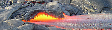
Lava flow at Hawaii Volcanoes National Park. NPS Photo.
Talk volcanoes and national parks and folks usually think of Hawaii Volcanoes National Park, and perhaps Lassen Volcanic National Park. In truth, though, there are at least 13 units of the national park system that have a volcanic past in some form or fashion.
It might be hard to believe, but even Isle Royale National Park and Voyageurs National Park, two parks best associated with lakes and the northwoods, have some volcanic geology.
To learn more about volcanics and the national park system, I turned to Dr. Robert Janiskee, a distinguished professor emeritus in the Geography Department at the University of South Carolina's Columbia campus. Dr. Janiskee, you might recall, offers a course available via the Internet that takes you through much of the national park system. Dubbed simply "Geography C370," the independent learning course is designed to familiarize students with "the physical, cultural, managerial, and user characteristics of America’s national park system."
The following checklist of national parks with volcanic histories comes courtesy of Dr. Janiskee.
Oregon’s Crater Lake National Park, which is situated in the Cascade Range, features America’s deepest and clearest lake, a six-mile wide, 1,932-foot deep, indescribably beautiful caldera lake formed by the collapse of ancient Mount Mazama about 7,700 years ago. Crater Lake National Park was established in 1902 and is our fifth-oldest national park. The grand old Crater Lake Lodge is on the National Register of Historic Places.
Craters of the Moon National Monument & Preserve is situated on the Snake River Plain in Idaho. It has a weird looking “moonscape” appearance because of its three geologically young lava fields that cover almost half a million acres. In addition to the massive lava flows, related processes created lava tubes, cinder cones, and other interesting volcanic features.
Devils Tower National Monument in Wyoming was America’s very first national monument (established 1906). The dramatic tower, which was featured in the film “Close Encounters of the Third kind,” is not a volcanic plug, as some people think, but rather an eroded sill of basalt that exhibits highly distinctive columnar fracture.
Haleakala National Park on the island of Maui in Hawaii is focused on a dormant shield volcano that towers more 10,000 above sea level. Like the shield volcanoes of the Big Island (Hawaii), Haleakala (Hawaiian for “House of the Sun”) was formed as the Pacific Plate slowly moved over a “hotspot” that supplied vast amounts of magma.
Hawaii Volcanoes National Park on the Big Island features two giant shield volcanoes, Kilauea and Mauna Loa. Both volcanoes are active, and Kilauea is one of the most active in the world. This park is perhaps the single best place on the planet to see active volcanism.
Michigan’s Isle Royale National Park is situated on a Lake Superior island that consists of ancient volcanic bedrock that is part of the vast Canadian Shield. Isle Royale is renowned for its remote wilderness qualities and its wildlife, especially moose and the wolves that prey on them.
Katmai National Park & Preserve on the southeastern coast of Alaska exhibits classic “Ring of Fire” activity. In 1912, the park’s Novarupta Volcano erupted, creating the ash-filled “Valley of Ten Thousand Smokes” where steam rises from countless fumaroles.
Volcanic interests aside, the main reason tourists go to Katmai is to watch brown bears (coastal grizzlies). Katmai has the world’s largest concentration of brown bears, and the bears’ seasonal gathering to feed on migrating salmon makes it easy to view them from observation platforms overlooking waterfalls where the bears catch the fish.
Lassen Volcanic National Park is situated in the Cascade Mountains of northern California where volcanic activity has been going on for about 600,000 years. This park has a stratovolcano, cinder cones, and lots of other interesting features such as steam vents, mudpots, boiling pools, and painted dunes. A series of eruptions in 1914-1921 created lots of “fresh” volcanic features.
Violent eruptions on the Medicine Lake shield volcano created an extremely rugged landscape at Lava Beds National Monument in northern California. In addition to more than 500 lava tube caves, which are very popular with visitors, the park has cinder cones, lava flows, spatter cones, pit craters, and other volcanic features. Indians used this rugged site for a natural fortress during the Modoc War of 1872-1873 when a group of 53 Modoc Indian warriors and their families held off a U.S. force ten times their size for five months
Washington’s Mount Rainier National Park is also in the Cascade Range. Mt. Rainier is a huge stratovolcano that is dormant, but not extinct. Some geologists fear that renewed volcanic activity could cause catastrophic damage and loss of life in the Seattle vicinity. Being easily accessible from the Seattle area – and visible on clear days -- Mount Rainer is very popular with hikers, climbers, and sightseers.
The main attraction at Sunset Crater National Monument in Arizona is a classic cinder cone volcano. The upper part of the cone is colored as if by sunset.
The core of Yellowstone National Park (Wyoming, Montana, and Idaho) occupies a giant caldera. The park’s famed geothermal features owe their existence to a hot spot lying relatively close to the surface at this location. The geologic record reveals that volcanic eruptions of stupendous proportions have occurred here and could happen again.
Voyageurs National Park on the Canadian border in northern Minnesota encompasses a sprawling area of glacier-scraped ancient volcanic bedrock called the Canadian Shield (or Laurentian Shield). The wilderness and backcountry landscape is blanketed with lakes, streams, wetlands, and forest.
Story Categories:
A copy of National Parks Traveler's financial statements may be obtained by sending a stamped, self-addressed envelope to: National Parks Traveler, P.O. Box 980452, Park City, Utah 84098. National Parks Traveler was formed in the state of Utah for the purpose of informing and educating about national parks and protected areas.
Residents of the following states may obtain a copy of our financial and additional information as stated below:
- Florida: A COPY OF THE OFFICIAL REGISTRATION AND FINANCIAL INFORMATION FOR NATIONAL PARKS TRAVELER, (REGISTRATION NO. CH 51659), MAY BE OBTAINED FROM THE DIVISION OF CONSUMER SERVICES BY CALLING 800-435-7352 OR VISITING THEIR WEBSITE. REGISTRATION DOES NOT IMPLY ENDORSEMENT, APPROVAL, OR RECOMMENDATION BY THE STATE.
- Georgia: A full and fair description of the programs and financial statement summary of National Parks Traveler is available upon request at the office and phone number indicated above.
- Maryland: Documents and information submitted under the Maryland Solicitations Act are also available, for the cost of postage and copies, from the Secretary of State, State House, Annapolis, MD 21401 (410-974-5534).
- North Carolina: Financial information about this organization and a copy of its license are available from the State Solicitation Licensing Branch at 888-830-4989 or 919-807-2214. The license is not an endorsement by the State.
- Pennsylvania: The official registration and financial information of National Parks Traveler may be obtained from the Pennsylvania Department of State by calling 800-732-0999. Registration does not imply endorsement.
- Virginia: Financial statements are available from the Virginia Department of Agriculture and Consumer Services, 102 Governor Street, Richmond, Virginia 23219.
- Washington: National Parks Traveler is registered with Washington State’s Charities Program as required by law and additional information is available by calling 800-332-4483 or visiting www.sos.wa.gov/charities, or on file at Charities Division, Office of the Secretary of State, State of Washington, Olympia, WA 98504.
INN Member

The easiest way to explore RV-friendly National Park campgrounds.

Here’s the definitive guide to National Park System campgrounds where RVers can park their rigs.
Our app is packed with RVing- specific details on more than 250 campgrounds in more than 70 national parks.
You’ll also find stories about RVing in the parks, tips helpful if you’ve just recently become an RVer, and useful planning suggestions.

Comments
You forgot to list the Lava Cave Monument in NE California just south of the Oregon border.
How about Devils Postpile National Monument? The basalt columns are the result of a lava flow.
The US Forest Service has two more National Monuments worth mentioning in this context: Newberry National Volcanic Monument and of course Mount St. Helens National Volcanic Monument.
The BLM has Cascade-Siskiyou National Monument with Pilot Rock, a basalt rock like Devil's Tower, and there are several basalt rocks like that in Upper Missouri River Breaks National Monument. And I probably missed a few ...
Ken,
Can't locate a "Lava Cave National Monument." Could you be referring to Lava Beds National Monument?
MRC, good catch. I thought I had seen Devils Postpile in the list, but my eyes deceived me.
Kurt
You forgot a couple in New Mexico: both Capulin Volcano National Monument and El Malpais National Monument feature volcanic landscapes.
Petroglyph NM contains three small volcanoes too, right at the western park border.
North Cascades National Park in Washington also contains a part of the Cascade range of volcanos.
Hey Kurt-
Could you ask the distinguished professor what his criteria were when he responded to your inquiry? There were obviously some omissions in his reply, as is evidenced by the readers, and I'm quite certain that he did not purposefully intend to mislead anyone into thinking that his was a complete compilation. I'm just curious as to how his determinations were made for the article.
Lone Hiker,
Boy, this is a tough crowd today.
The list was not intended to be all-inclusive. As the second sentence of the post said, there are "at least 13..."
There was no misleading nor intention that the list was complete. Rather, it was merely intended to show a representative sample. That other sites have been mentioned is great; shows there's some thinking going on out there.
OK, I realize it was just a "highlight film" for volcanic parks, but technically every park on the Hawaiian Islands exists because of volcanism and even the cultural parks are inextricably linked to the volcanoes on which they lived.. moreso in some Hawaiian parks than others, of course. I wouldn't attempt to connect the USS Arizona with volcanism... although... those pesky Japanese pilots sure did come from a volcanic chain of islands across the Pacific, now didn't they?
The massive layers of fish fossils at Fossil Butte are also believed to have been caused by periodic local eruptions which caused massive fish kills in the former Fossil Lake. The potential tangential references are endless!
I don't believe, in my heart of hearts, that anyone was trying to berate or take you to task Coach. Personally, I was, as I stated, just curious about his train of thought. I was thinking perhaps his belief was that these (the items highlighted in the above listing) stood for the most obvious examples within the park system, but then I started recalling a certain excursion over the Lava Falls Rapids, and wondered aloud (I glad there wasn't anyone in the room at the time) how this section of a very well known and studies park wasn't fit for inclusion. In the history of our little corner of the world, dating back to the pre-Cambrian era, and maybe a bit prior, you'd be hard pressed to find some little corner of the continent that is totally devoid of volcanism at some level, so in actuality, the list could be all-inclusive, to some degree. But I think he did a fairly competent job with the major examples, without splitting hairs between the parks, monuments, preserves, etc.
<>
In 2000, the USGS along with a team of private consultants, performed a new bathymetric survey of the subsurface caldera of Crater Lake. The newest USGS estimate for the maximum depth of Crater Lake is 1949 feet give or take about 6 feet. The average depth is 1148 feet give or take about 3 feet. Crater Lake is the deepest lake in the USA, 2nd in North America, and 8th in the world. More on this subject can be read at http://www.craterlakeinstitute.com/about-us/how-deep-crater-lake.htm
Owen Hoffman
Oak Ridge, TN 37830
There are many dozens of units in the Park System that have landforms of volcanic origin within their borders. As Kurt has already explained, the list he extracted from one of the reading modules for my national parks course was only a sample, not a comprehensive listing. I compiled that sample for my students to show that parks with landforms of volcanic origin are distributed widely, exhibit interesting extrusive and intrusive volcanic features, and do not necessarily have volcanic terms as part of their name.
Actually, I was just refreshed that this was a topic I could talk about without being called names... Really, my love for many of the great parks and my love of geology go hand in hand and I was just enjoying the continuation of the list! Meant no disrespect... I just got excited!
Here's one I wasn't aware of -- from a William and Mary (flat hat) news article today. I assumed anywhere there's continental drift there's a chance for magma and the like, but didn't know these details...
<><><><><>
According to the National Park Service, 1 to 1.2 billion years ago, tectonic plates collided to form the Grenville Mountain range in the area where the Appalachian Mountains now stand.
Around 570 million years ago, tectonic plates moved apart and lava began to flow, erupting at rift zones along the surface. The lava flows that exuded from the rift zones formed the Catoctin Formation, creating broad, rolling plains similar to those found around Big Meadows in the Shenandoah National Park. The original lava flows were originally composed of basalt.
As they metamorphosed, they became richer in chlorite and epidote, and then became greenstones, which cap many peaks in the park. These greenstones produce jagged cliffs composed of very fine grains. The rocks tend to be of a light gray to rusted red color, but if freshly exposed, they appear green.
There's a great arch of pillow basalt on the way to the Pt. Bonita Lighthouse in GGNRA, Sausalito, Ca. And Olympic N.P., west of Seattle, has some near Hurricane Ridge.
The ranger program 'Above the River's Roar' featured lava dams to the Colorado River in Grand Canyon; the tallest was 2,388 feet tall and 84 miles long.
I believe the columns at Devil's Tower are of phonolite.
R.I.P., Eric York.
Jeez, you guys are sharp. Nick is absolutely right that Devil’s Tower consists of phonolite porphyry, not basalt. That’s a good catch, since the distinction is quite important. Differing chemical composition aside, the two rocks aren’t formed the same way and don’t look alike. Porphyritic phonolite is an intrusive igneous rock that is formed from magma that cools relatively slowly below the earth surface. It is lighter- colored, and when formed from magma that begins cooling slowly enough it will have distinctive mineral crystals (phenocrysts) imbedded in a groundmass matrix. Basalt, an extrusive igneous rock that cools quickly on the surface, is fine-grained and also much darker than phonolite. You don’t find big mineral crystals in basalt because the hurry-up cooling process that produces it doesn’t provide enough time for the various molecules in the melt to get together and line up at the leisurely pace needed to form big crystals. A quick glance at Devil’s Tower might lead you to think you’re looking at basalt because the phonolite exhibits columnar jointing similar to that of Devil’s Postpile and many other basalt landforms.
I heard that Devils Tower was created by a giant bear trying to claw its way up the side of the mountain... now who do I believe? Hmmm...
I see you're up to date on the Native American lore Jon. Yup, hunting bears can be a dangerous undertaking. FYI- the would-be hunter lived to tell the tale.
The bigger they are, the harder they claw...
Don't forget Pinnacles National Monument, south of the San Francisco CA area.
From the park's web page:
"Pinnacles National Monument gets its name from rock spires and crags that are remnants of an ancient volcano. The volcano eroded over millions of years as it moved northward along the San Andreas Fault. Rock debris in the form of boulders has weathered and settled, leaving behind spires of volcanic rock and talus caves."
Here's a stretch. Did you know there's evidence of volcanic activity in South Florida's Biscayne National Park? In this land of limestone, you can find pumice on the oceanside shoreline of Elliott Key. Amidst the piles of other marine debris (both natural and unnatural), this floating volcanic rock likely came from Caribbean volcanoes which have erupted over the past several decades.