
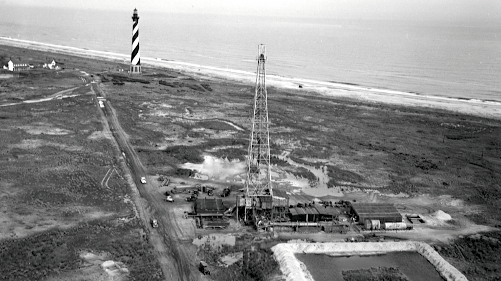
Most people standing beneath the black-and-white spiral of the Cape Hatteras Lighthouse assume the ground beneath them is just sand, shells, and more sand.
They don’t realize they’re standing next to one of the deepest oil wells ever drilled on the Eastern Seaboard.
In late 1945, just after World War II, Standard Oil of New Jersey arrived on Hatteras Island with enormous fanfare. Newspapers called it “the most important wildcat venture in eastern America.” Executives drove a ceremonial stake into the dunes less than a third of a mile from the lighthouse, marking the location of North Carolina Esso No. 1, also known as Hatteras Light Well No. 1.
This wasn’t a production gamble. It was a scientific endeavor and engineering marvel of its day.
The East Coast had been rocked by German U-boats only a few years earlier, cutting off tanker traffic and exposing how vulnerable America’s energy supply really was. Geologists knew thick Cretaceous sediments paralleled the Atlantic coast and those same-aged rocks produced oil in the Gulf. If oil existed offshore, the only way to know was to drill.
And drill they did.
A 168-foot derrick rose from the dunes. Millions of pounds of equipment were barged through Pamlico Sound and dragged across soft sand by Caterpillar tractors. Crews worked twelve-hour shifts, around the clock, through storms and nor’easters. Local islanders, fishermen, Coast Guardsmen, seamen, became roughnecks almost overnight.
By July 1946, the well had reached 10,054 feet, bottoming out in crystalline granite basement rock. At the time, it was described in the Bulletin of the American Association of Petroleum Geologists as the deepest well ever drilled along the Atlantic Coastal Plain from Maine to Florida.
There was no commercial oil. But the well was anything but a failure.

The well was plugged and abandoned in 1946, sealed with cement and mud, its surface traces slowly erased by wind, salt, and shifting dunes.
Then, half a century later, history nearly crossed paths with it again.
In 1999, as the Atlantic Ocean's erosion crept ever closer, the National Park Service undertook the extraordinary effort to move the Cape Hatteras Lighthouse 2,900 feet inland, one of the most ambitious historic preservation projects ever attempted. It was known as "The Move of the Century."
What almost no one realized at the time was how close that new site came to a forgotten piece of energy infrastructure.
The original well had been surveyed relative to the lighthouse’s old position. As decades passed, landmarks vanished and coordinates blurred. By the time the lighthouse was moved, the well had largely slipped from living memory.
In 2023, while working as the chief petroleum engineer for the National Park Service, I was tasked with relocating that well, physically, on the ground.
We found it. Using old plat maps and section tracts while referencing old photos we were able to locate the capped wellhead buried about four feet below the sand dunes.
The plugged and abandoned Hatteras Light well sits about 50 feet from where the lighthouse stands today.
Fifty feet...

Thankfully nothing dramatic happened. No leaks. No crisis. Just a journey into America's oil exploration past.
America drilled millions of wells, many of them scientifically important, some of them economically hopeful, in places that later became playgrounds, neighborhoods, monuments, parks, and even national icons. Most were responsibly plugged for their time. Though many were not. And some, like this one, end up forgotten until history and the modern world nearly collided.
This is what legacy wells really are.
They're not just an environmental issue. They're not just an energy story. They are a buried layer of our national past, sometimes waiting patiently beneath the places we treasure most.
Forrest Smith is director of engineering and a well & asset decommissioning specialist for TAQ Energy. He had worked for the National Park Service until last fall.
Stories about:
Story Categories:
A copy of National Parks Traveler's financial statements may be obtained by sending a stamped, self-addressed envelope to: National Parks Traveler, P.O. Box 980452, Park City, Utah 84098. National Parks Traveler was formed in the state of Utah for the purpose of informing and educating about national parks and protected areas.
Residents of the following states may obtain a copy of our financial and additional information as stated below:
- Florida: A COPY OF THE OFFICIAL REGISTRATION AND FINANCIAL INFORMATION FOR NATIONAL PARKS TRAVELER, (REGISTRATION NO. CH 51659), MAY BE OBTAINED FROM THE DIVISION OF CONSUMER SERVICES BY CALLING 800-435-7352 OR VISITING THEIR WEBSITE. REGISTRATION DOES NOT IMPLY ENDORSEMENT, APPROVAL, OR RECOMMENDATION BY THE STATE.
- Georgia: A full and fair description of the programs and financial statement summary of National Parks Traveler is available upon request at the office and phone number indicated above.
- Maryland: Documents and information submitted under the Maryland Solicitations Act are also available, for the cost of postage and copies, from the Secretary of State, State House, Annapolis, MD 21401 (410-974-5534).
- North Carolina: Financial information about this organization and a copy of its license are available from the State Solicitation Licensing Branch at 888-830-4989 or 919-807-2214. The license is not an endorsement by the State.
- Pennsylvania: The official registration and financial information of National Parks Traveler may be obtained from the Pennsylvania Department of State by calling 800-732-0999. Registration does not imply endorsement.
- Virginia: Financial statements are available from the Virginia Department of Agriculture and Consumer Services, 102 Governor Street, Richmond, Virginia 23219.
- Washington: National Parks Traveler is registered with Washington State’s Charities Program as required by law and additional information is available by calling 800-332-4483 or visiting www.sos.wa.gov/charities, or on file at Charities Division, Office of the Secretary of State, State of Washington, Olympia, WA 98504.
INN Member

The easiest way to explore RV-friendly National Park campgrounds.

Here’s the definitive guide to National Park System campgrounds where RVers can park their rigs.
Our app is packed with RVing- specific details on more than 250 campgrounds in more than 70 national parks.
You’ll also find stories about RVing in the parks, tips helpful if you’ve just recently become an RVer, and useful planning suggestions.

