
“The Indians have made 2 piles of Stone on the top of this Tower. The nativs have ingraved on the face of this rock the figures of animals &c. near which I marked my name and the day of the month & year.” William Clark, July 25, 1806
The Corps of Discovery spent nearly two-and-a-half years (May 1804 - September 1806) on a journey to explore the West in search of a primary water route to the Pacific Ocean. Captains Meriwether Lewis and William Clark were also charged by President Thomas Jefferson with gathering scientific information and establishing a trade network while befriending Native Americans.
The majority of the journey was via rivers, including the Missouri, Clearwater, Snake, Columbia and Yellowstone. Despite the time and distance, virtually no visual physical evidence of the journey remains other than detailed notes and journals of the two leaders and several members of the Corps of Discovery. An exception is William Clark’s inscription on a landmark along the south bank of the Yellowstone River.
To gain greater knowledge of the land they were to explore, Lewis and Clark separated the group and took different routes during a portion of their 1806 return to St. Louis. Near today’s Missoula, Montana, at Travelers Rest, a location visited during their outbound journey, Meriwether Lewis and nine members of the Corps of Discovery headed north to explore the Marias River while William Clark led a group south to follow the Yellowstone River northeast to its junction with the Missouri River. There the two would meet approximately a month later at the convergence of the Yellowstone and the Missouri rivers.
Descending the Yellowstone River during the late afternoon of July 25, Clark and eight companions, including Sacajawea and her year-old son, Jean Baptiste Charbonneau (nicknamed “Pomp” by Clark), stopped beside a large sandstone outcropping described by Clark as a “remarkable rock.”
Climbing to the top, he noted “…. a most extensive view in every direction.”
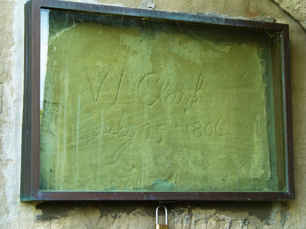
Clark would name the rock “Pompey’s Tower” (later altered to “Pompeys Pillar” in a published history) in honor of Sacajawea’s son. Clark’s journal noted he engraved his name and the date on the face of the rock that included numerous native engravings. Clark, described as a “creative speller,” noted the rock as “200 feet high and 400 paces in secumphrance.” He also mentioned the “Clift of lightish Coloured gritty rock on the top there is a tolerable Soil of about 5 or 6 feet thick Covered with Short grass.” The captain overestimated the outcropping’s height that is noted by the Bureau of Land Management as 120 feet.
Pompeys Pillar was designated part of the Lewis and Clark National Historic Trail in 1985 and established as a national monument in 2001. The 51-acre monument is administered by the Bureau of Land Management, which purchased the property in 1991 from a Billings, Montana, family apparently planning a major tourist development at the site.
The monument includes a visitor center offering a video presentation, exhibits, and a small gift shop. The site also includes replicas of two dugout canoes Clark had lashed together to offer more stability when traveling the Yellowstone River.
A short walking trail from the visitor center leads to a series of 220 wooden steps providing access to Clark’s inscription and the top of the outcropping. The inscription, covered by glass for protection from the elements, is about halfway to the top. While Clark misjudged the height of the outcropping, he was accurate in his description of the view from top.
Interestingly, the Northern Pacific Railway held an early right-of-way through this area and had an iron grate sunk into the rock to protect Clark’s signature from vandalism. In 1926 the railroad authorized a Billings company to cut the inscription deeper into the stone.
During a road trip following the Lewis and Clark National Historic Trail between St. Louis and the Pacific Coast we followed the westward route taken by the Corps along the Missouri River. As a result we missed Pompeys Pillar, which is located alongside the south bank of the Yellowstone River on the route Clark traveled during his return east.
Several years later during another road trip through Montana we made a point to visit Pompeys Pillar. The outcropping is quite imposing and viewing William Clark’s etching is a moving experience. Seeing his name and the date etched into the sandstone seemed to convey a strange closeness to the explorer, almost as if he was nearby. Continuing to the top, we were treated to an impressive panorama that included the Yellowstone River on which Clark and his men continued east to join Meriwether Lewis and the remainder of the group before following the Missouri River home to St. Louis.
Pompeys Pillar National Monument is located in southeastern Montana, 28 miles east of Billings, a short distance off Interstate 94 (exit 23). The visitor center is open from the beginning of May through the end of September. Walk-ins are welcome during daylight hours the remainder of the year. The entrance fee is $7 per private vehicle. America the Beautiful and other federal passes are accepted.
David and Kay Scott are authors of “Exploring the Oregon Trail: America’s Historic Road Trip” (Globe Pequot). Visit them at blog.valdosta.edu/dlscott.
Stories about:
Story Categories:
A copy of National Parks Traveler's financial statements may be obtained by sending a stamped, self-addressed envelope to: National Parks Traveler, P.O. Box 980452, Park City, Utah 84098. National Parks Traveler was formed in the state of Utah for the purpose of informing and educating about national parks and protected areas.
Residents of the following states may obtain a copy of our financial and additional information as stated below:
- Florida: A COPY OF THE OFFICIAL REGISTRATION AND FINANCIAL INFORMATION FOR NATIONAL PARKS TRAVELER, (REGISTRATION NO. CH 51659), MAY BE OBTAINED FROM THE DIVISION OF CONSUMER SERVICES BY CALLING 800-435-7352 OR VISITING THEIR WEBSITE. REGISTRATION DOES NOT IMPLY ENDORSEMENT, APPROVAL, OR RECOMMENDATION BY THE STATE.
- Georgia: A full and fair description of the programs and financial statement summary of National Parks Traveler is available upon request at the office and phone number indicated above.
- Maryland: Documents and information submitted under the Maryland Solicitations Act are also available, for the cost of postage and copies, from the Secretary of State, State House, Annapolis, MD 21401 (410-974-5534).
- North Carolina: Financial information about this organization and a copy of its license are available from the State Solicitation Licensing Branch at 888-830-4989 or 919-807-2214. The license is not an endorsement by the State.
- Pennsylvania: The official registration and financial information of National Parks Traveler may be obtained from the Pennsylvania Department of State by calling 800-732-0999. Registration does not imply endorsement.
- Virginia: Financial statements are available from the Virginia Department of Agriculture and Consumer Services, 102 Governor Street, Richmond, Virginia 23219.
- Washington: National Parks Traveler is registered with Washington State’s Charities Program as required by law and additional information is available by calling 800-332-4483 or visiting www.sos.wa.gov/charities, or on file at Charities Division, Office of the Secretary of State, State of Washington, Olympia, WA 98504.
INN Member

The easiest way to explore RV-friendly National Park campgrounds.

Here’s the definitive guide to National Park System campgrounds where RVers can park their rigs.
Our app is packed with RVing- specific details on more than 250 campgrounds in more than 70 national parks.
You’ll also find stories about RVing in the parks, tips helpful if you’ve just recently become an RVer, and useful planning suggestions.
