
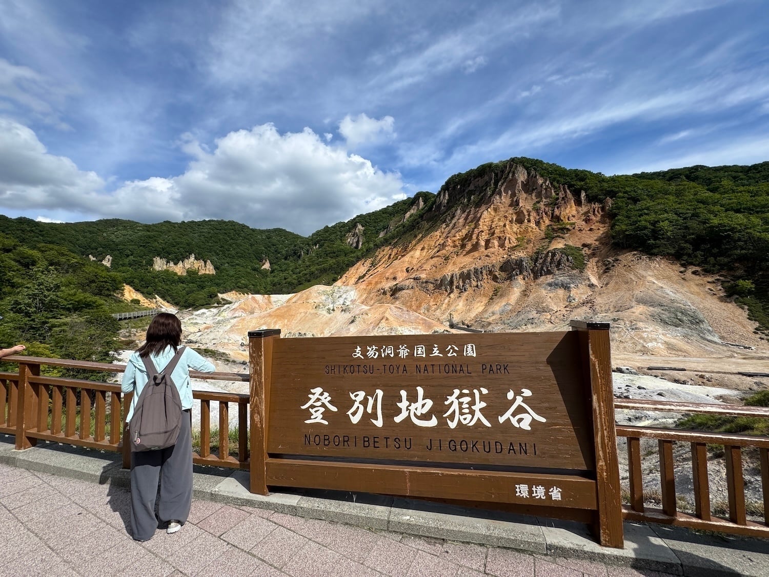
The sulfurous scent of boiled eggs hung in the forest air as Hell Valley hikers neatly arranged themselves along a wooden platform, kicked off their shoes and plunged their aching feet into milky-blue water.
Most people relaxed on the comfortable “pads for footbathing” you could borrow from a waterproof tub. But a few of us restless sorts waded over to the base of a small waterfall to test the temperature of the thermal waters as they spilled over rocks from above.
“Hot water and mud may erupt suddenly and the footbath could be too hot,” a sign warned in four languages.
Nothing that dramatic happened, but those contemplative moments at the Oyunuma Brook Natural Footbath in Shikotsu-Toya National Park sure left a multi-sensory impression. So did the volcanic landscape and the benevolent Japanese demon statues around the nearby town of Noboribetsu Onsen that serve as guardians of the hot springs.
Hokkaido, Japan’s northernmost region, is home to seven of the country’s 35 national parks. Flying into Wakkanai and out of Sapporo, I got to experience two of them and see how they differ from what we're used to in North America.
For starters, there are no gates or admission fees so it can be hard to know when you’re in a park. Some protected land is government owned, but much is in private hands and managed by Japan’s Ministry of the Environment. You won’t likely see any rangers unless you arrange to meet them for interviews like I did.
“People don’t always know they’re even in a national park,” ranger Hitoshi Nakamura from the Wakkanai Ranger Office told me through a translator when we met in a hotel lobby. “A lot of Japanese people travel because of national parks, but I’m not sure those who visit national parks always mean it or if they understand it’s a national park or not.”

Wakkanai is so far north that you can see Russia’s Sakhalin Island from Cape Soya on a clear day because it’s just 26 miles away.
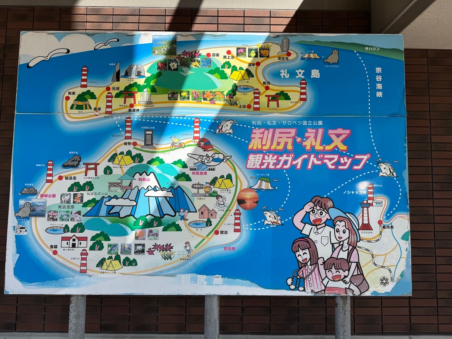
This city is the launch point for Rishiri-Rebun-Sarobetsu National Park. Japan's northernmost national park is made up of parts of two tiny islands (Rishiri and Rebun) with entirely different personalities, plus a stretch of coastline that’s home to the Sarobetsu Plains, bird-friendly wetlands and two visitor centers.
When you arrive at Wakkanai’s ferry terminal, expect to be bombarded with posters and pictures of Rebun Island’s famous alpine flowers. Some 300 species bloom here thanks to the high latitude and cool climate, and can be appreciated along the coast and at other low-lying spots.
Flower trekking is popular and “flower rangers” (locals, not park staff) keep tabs on things and help deter the poaching that was a significant problem several decades ago. Maps have tantalizing notations like “Large Field of Rebun’s lady slipper orchid” and “Large field of Asian skunk cabbage.”
After a two-hour ferry crossing to the sleepy island of just 2,200 people in the Sea of Japan, I posed for photos with a cute statue of the island’s mascot character Atsumon, who was inspired by the yellow-white Rebun Atsumoriso. It was as close as I would get to the lady slipper orchid.

Rebun — just 18 miles long and five miles wide — is known as the “Floating Island of Flowers.” I visited two coastal viewpoints, found the fading national park sign in one of them, and hiked part of the Momoiwa Observatory Trail.
The only catch was that it was late August, blessedly cooler than Tokyo with temperatures hovering under 70F, but just a smidge too late for the famous orchid and the “Princess of Alpine Plants” (Rebun Usuyukiso), whose pale leaves resemble “a light layer of fallen snow.”
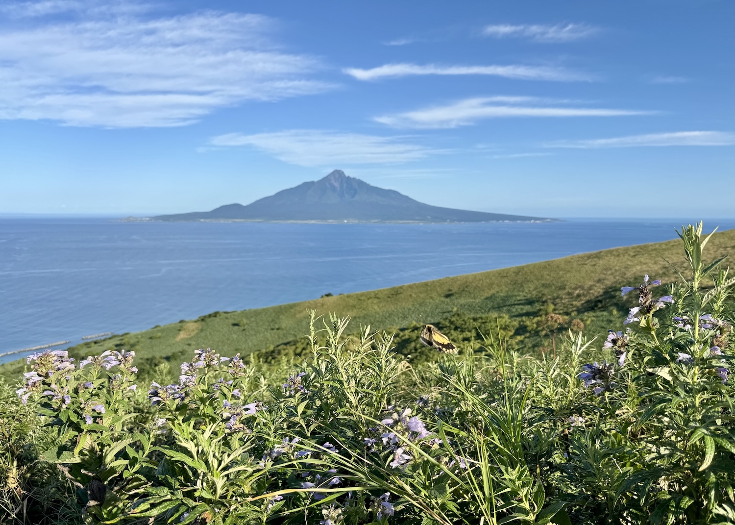
There were a few late-season beauties still blooming, and clear views of Rishiri Island, a conical volcanic island formed from the extinct volcanic peak of Mt. Rishiri.
The next day I caught a one-hour ferry south to Rishiri, a buzzing island with 5,000 people and Japan's northernmost whisky distillery. It's about 19 miles long and barely nine miles wide, and you can rent bikes and cycle around the island.
The waters surrounding both islands are home to Rishiri kombu, a high-grade kelp, and sea urchins, a local delicacy that shows up in everything from ramen to ice cream creations (really).
It takes about 10 hours to hike the mountain, lovingly dubbed Rishiri-Fuji because it resembles Mt. Fuji. It's the symbol of the park. Erosion is a problem with the fragile volcanic soil near the peak and since there aren’t any outhouses along the trail, you're encouraged to buy mobile toilet bags at the local Seicomart and use them behind special privacy “booths."

Nature guide Hiroto Kumagai took me for a much easier walk.
The park’s Himenuma Swamp is an artificially created pond that combined several small swamps and springs and got its name because it was stocked with landlocked kokanee salmon (himemasu).
You can often see the upside-down reflection of Mt. Rishiri on the surface of the water, but the 5,656-foot-tall mountain was cloaked in clouds when I visited. Instead, I looped around the swamp on a tranquil path through primeval forest hoping to see Japanese robins and Black woodpeckers, but making do with cormorants.
I did stop to ponder some of the posted national park rules.
What we call rules are politely translated here as “field manners.” Bring back your trash. Don’t pick plants. Don't feed wild animals. Don’t smoke while walking. Bring a portable ashtray and take your cigarette butts home. Smoke only in designated areas.
“Nature is not only yours,” one sign stressed. “Nature belongs to nobody. Care about all living things and nature.”

Of all the living things I dreamed of seeing in Hokkaido’s national parks, a raccoon dog (tanuki), Ezo red fox and Ezo squirrel topped the list. So did the Shima-Enaga, the Long-tailed Tit that looks like a snowball and is nicknamed the Snow Fairy.
Only a single fox sighting was meant to be. That happened after flying from Rishiri Island to Sapporo, and escaping the city of two million for that footbathing day trip to Shikotsu-Toya National Park.
That road trip was rounded out with time admiring Lake Shikotsu (a caldera lake) and meeting four park rangers for a ride up the Mt. Usu Ropeway (an aerial tram) to talk about the volcanic landscape and how the park became Japan's first UNESCO Global Geopark.

There was a whirl through the Toyako Visitor Center and Volcano Science Museum, learning how locals live with the threat of volcanic eruptions.
There were moments that felt very North American, like reading about invasive signal crayfish in the lakes and hearing that bike rentals had been suspended because of a brown bear sighting.
There were kitschy swan pedal boats and an outdoor sculpture gallery.

Through all these adventures, Chiyuki Okada, who has been guiding people through Japan for 30 years, was most excited to share the footbath.
For logistical reasons, we had to do things backwards, but you should make a day of it. Start at the park service center, hike some of Hell Valley's trails, meander through the shaded forest and end with your feet dipped in warm water for half an hour, an hour or even more.
"On a beautiful day like today, it’s heaven," said Okada before we reluctantly dried our feet and prepared to leave Hell Valley.

Stories about:
Story Categories:
A copy of National Parks Traveler's financial statements may be obtained by sending a stamped, self-addressed envelope to: National Parks Traveler, P.O. Box 980452, Park City, Utah 84098. National Parks Traveler was formed in the state of Utah for the purpose of informing and educating about national parks and protected areas.
Residents of the following states may obtain a copy of our financial and additional information as stated below:
- Florida: A COPY OF THE OFFICIAL REGISTRATION AND FINANCIAL INFORMATION FOR NATIONAL PARKS TRAVELER, (REGISTRATION NO. CH 51659), MAY BE OBTAINED FROM THE DIVISION OF CONSUMER SERVICES BY CALLING 800-435-7352 OR VISITING THEIR WEBSITE. REGISTRATION DOES NOT IMPLY ENDORSEMENT, APPROVAL, OR RECOMMENDATION BY THE STATE.
- Georgia: A full and fair description of the programs and financial statement summary of National Parks Traveler is available upon request at the office and phone number indicated above.
- Maryland: Documents and information submitted under the Maryland Solicitations Act are also available, for the cost of postage and copies, from the Secretary of State, State House, Annapolis, MD 21401 (410-974-5534).
- North Carolina: Financial information about this organization and a copy of its license are available from the State Solicitation Licensing Branch at 888-830-4989 or 919-807-2214. The license is not an endorsement by the State.
- Pennsylvania: The official registration and financial information of National Parks Traveler may be obtained from the Pennsylvania Department of State by calling 800-732-0999. Registration does not imply endorsement.
- Virginia: Financial statements are available from the Virginia Department of Agriculture and Consumer Services, 102 Governor Street, Richmond, Virginia 23219.
- Washington: National Parks Traveler is registered with Washington State’s Charities Program as required by law and additional information is available by calling 800-332-4483 or visiting www.sos.wa.gov/charities, or on file at Charities Division, Office of the Secretary of State, State of Washington, Olympia, WA 98504.
INN Member

The easiest way to explore RV-friendly National Park campgrounds.

Here’s the definitive guide to National Park System campgrounds where RVers can park their rigs.
Our app is packed with RVing- specific details on more than 250 campgrounds in more than 70 national parks.
You’ll also find stories about RVing in the parks, tips helpful if you’ve just recently become an RVer, and useful planning suggestions.
