
Editor's note: Yellowstone Caldera Chronicles is a weekly column written by scientists and collaborators of the Yellowstone Volcano Observatory. This week's contribution is from Shaul Hurwitz, research hydrologist with the U.S. Geological Survey.
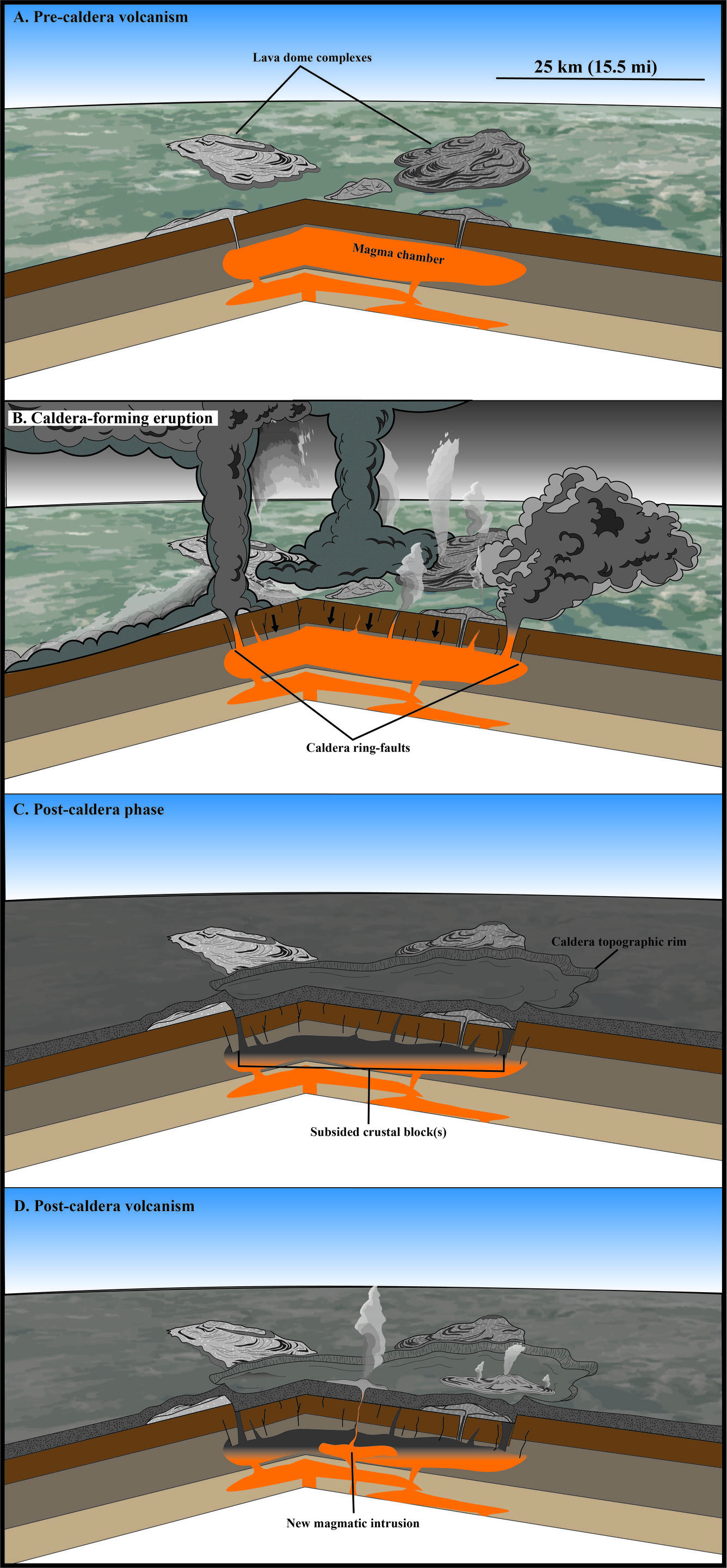
Based on geologic mapping and dating of minerals, we know that the Yellowstone caldera formed 631,000 years ago. But how did the caldera collapse? Observations and monitoring data from several caldera collapses at other volcanoes in the 20th and 21st centuries provide clues.
Many concepts and models used for explaining past caldera-forming eruptions and subsequent collapses were formulated by USGS scientist Robert L. Smith and his colleagues, mainly based on their work at Valles caldera in New Mexico. Subsequently, USGS scientist Peter Lipman’s research at Tertiary calderas of the San Juan Mountains in Colorado illuminated many fundamental processes linking large-volume eruptions and caldera collapses. Geologic mapping by USGS scientist Bob Christiansen suggested that the collapse of the Yellowstone caldera 631,000 years ago in response to the eruption of about 1,000 cubic kilometers (240 cubic miles) of magma occurred within hours or days.
However, recent field observations indicate a more complicated story of large caldera forming eruptions.

We can learn more about past volcanic eruptions and caldera collapses from observations of more recent eruptions. The 1912 Novarupta eruption on the Alaska Peninsula was the largest in the 20th century, with a Volcanic Explosivity Index value of 6. There were plenty of eyewitness accounts of the eruption, including observations made a few years later by Robert Griggs. About 15 cubic kilometers (3.5 cubic miles) of magma erupted over the course of 60 hours. An interesting observation was that the caldera did not collapse under Novarupta, but rather magma propagated laterally from beneath Mount Katmai, about 10.6 km (about 6.6 miles) to the northeast and which collapsed due to lateral drainage of its magma chamber. While unraveling details of the Novarupta eruption and the geologic history of the region several decades later, USGS scientists Wes Hildreth and Judy Fierstein were able to use information from the eyewitness accounts, and in contrast to geologic mapping at Yellowstone, they mapped landscapes that were less eroded and rocks that were less altered.
In the late 20th and early 21st centuries, the establishment of volcano monitoring networks allowed scientists to capture several caldera collapses in unprecedented detail. One of the best examples is from the 2018 eruption of Kīlauea Volcano on the Island of Hawai’i. Data collected with seismometers, tiltmeters, high-rate Global Positioning System (GPS) stations, and gas sensors helped document precursory activity, growth of the caldera, and subsurface lateral magma transport from Kīlauea‘s summit to the eruption site in the volcano’s Lower East Rift Zone, not unlike what occurred at Katmai and Novarupta 106 years prior. Over the three months of the eruption, the caldera at Kīlauea‘s summit subsided by more than 500 meters (1640 feet).
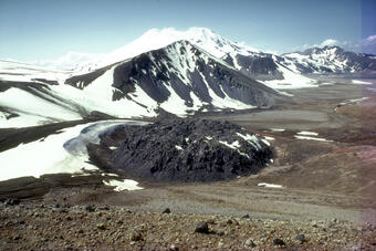
Many types of monitoring instruments captured the onset of subsurface magma transport, the evolving geometry of the subsiding caldera and its faults, and the amount of magma erupted during the 2014–2015 collapse of Bárðarbunga Caldera under the Vatnajökull glacier in Iceland. As at Katmai and Kīlauea, magma propagated laterally in the subsurface away from the caldera, erupting 1.5 cubic kilometers (0.35 cubic miles) of basaltic magma at Holuhraun, about 40 kilometers (25 miles) to the northeast.
Other caldera collapses in the 21st century that were captured by volcano monitoring networks include the 2000 collapse at Miyakejima Volcano in Japan and the 2007 collapse of Dolomieu crater at Piton de la Fournaise Volcano on Réunion Island in the Indian Ocean. Because of the increasing capacity to monitor volcanoes from space, even the 2018 eruption and caldera resurgence (in contrast to collapse) at the remote Sierra Negra volcano in the Galápagos Islands (Pacific Ocean) were documented in great detail by multiple instruments.
The ability to capture and document caldera collapse with modern monitoring networks provides scientists with diverse datasets to improve upon the early models proposed by Smith, Lipman, Christiansen, and others. Although a massive caldera-forming eruption like the one that resulted in Yellowstone caldera has never been witnessed, geologists can use modern examples, coupled with insights from the geologic history of the Yellowstone region, to better understand how caldera collapse occurs.
Stories about:
Story Categories:
A copy of National Parks Traveler's financial statements may be obtained by sending a stamped, self-addressed envelope to: National Parks Traveler, P.O. Box 980452, Park City, Utah 84098. National Parks Traveler was formed in the state of Utah for the purpose of informing and educating about national parks and protected areas.
Residents of the following states may obtain a copy of our financial and additional information as stated below:
- Florida: A COPY OF THE OFFICIAL REGISTRATION AND FINANCIAL INFORMATION FOR NATIONAL PARKS TRAVELER, (REGISTRATION NO. CH 51659), MAY BE OBTAINED FROM THE DIVISION OF CONSUMER SERVICES BY CALLING 800-435-7352 OR VISITING THEIR WEBSITE. REGISTRATION DOES NOT IMPLY ENDORSEMENT, APPROVAL, OR RECOMMENDATION BY THE STATE.
- Georgia: A full and fair description of the programs and financial statement summary of National Parks Traveler is available upon request at the office and phone number indicated above.
- Maryland: Documents and information submitted under the Maryland Solicitations Act are also available, for the cost of postage and copies, from the Secretary of State, State House, Annapolis, MD 21401 (410-974-5534).
- North Carolina: Financial information about this organization and a copy of its license are available from the State Solicitation Licensing Branch at 888-830-4989 or 919-807-2214. The license is not an endorsement by the State.
- Pennsylvania: The official registration and financial information of National Parks Traveler may be obtained from the Pennsylvania Department of State by calling 800-732-0999. Registration does not imply endorsement.
- Virginia: Financial statements are available from the Virginia Department of Agriculture and Consumer Services, 102 Governor Street, Richmond, Virginia 23219.
- Washington: National Parks Traveler is registered with Washington State’s Charities Program as required by law and additional information is available by calling 800-332-4483 or visiting www.sos.wa.gov/charities, or on file at Charities Division, Office of the Secretary of State, State of Washington, Olympia, WA 98504.
INN Member

The easiest way to explore RV-friendly National Park campgrounds.

Here’s the definitive guide to National Park System campgrounds where RVers can park their rigs.
Our app is packed with RVing- specific details on more than 250 campgrounds in more than 70 national parks.
You’ll also find stories about RVing in the parks, tips helpful if you’ve just recently become an RVer, and useful planning suggestions.

