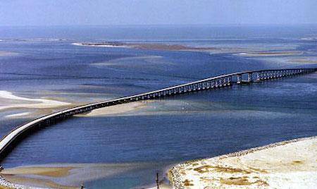
Hurdles finally have been cleared to allow construction of a bridge to replace the Bonner Bridge on North Carolina's Outer Banks/Outer Banks Task Force
For more than a quarter-century there have been discussions about replacing the bridge that ties together the Outer Banks and Cape Hatteras National Seashore, and now it appears that construction of a new bridge has been authorized.
The National Park Service last week signed off on the plan the North Carolina Department of Transportation has for replacement and demolition of the Herbert C. Bonner Bridge that was built in 1963 to span Oregon Inlet. The plan is to build a parallel bridge within the existing NC State Highway 12 corridor.
A $216 million design-build contract for the 3.5 mile-long replacement bridge was awarded by the state in 2011, but lawsuits tied up the project until now. That sum will be updated to meet current costs associated with the construction delay.
The selected action provides the basis for the National Park Service to grant a Federal Highway Easement Deed to the State of North Carolina for the new bridge and to issue a Special Use Permit regulating the construction activities in the Seashore associated with the project.
There are just two ways to reach Hatteras and Ocracoke islands -- either via the Bonner Bridge, or via ferry. Since 1989 there has been talk about replacing the Bonner Bridge, which is the only evacuation route for the two islands, short of ferries. NCDOT awarded a contract to a design-build team to replace the bridge in August 2011. Design work began immediately and construction of the replacement bridge was originally set to begin in early 2013. But a series of legal challenges by the Southern Environmental Law Center on behalf of the Defenders of Wildlife and National Wildlife Refuge Association put the project on hold. Those lawsuits were settled in August.
Under the settlement agreement, NCDOT will "consider options that would move vulnerable portions of N.C. Highway 12 out of the southern half of Pea Island National Wildlife Refuge and into Pamlico Sound," the transportation department said in a release.
The Record of Decision is available on the NPS Planning Environment and Public Comment (PEPC) website at: http://parkplanning.nps.gov/caha. Additional information is available on the PEPC website or by contacting Cape Hatteras National Seashore, 1401 National Park Drive, Manteo, NC 27954, (252) 475-9030.


Comments
The SELC (Southern Environmental Law Center) is responsible for at least 10 years of litigation and tens of millions of dollars spent at their law firm opposing the bridge replacement in the name of saving the birds of Pea Island NWR into which the bridge returns people to land on highway 12 in NC. The millions of your taxpayer dollars spent in trying to fight the SELC to get the bridge replaced is sinful and the delays are shameful.
Ocracoke Island is only accessible by ferry.
SELC is a wonderful conservation organization with dedicated lawyers and staff. Their advocacy in trying to stop an ill conceived plan of bridges on a national wildlife refuge was commendable. The state's plan called for 2 additional bridges to be built on the refugee, keeping the refugee in a perpetual state of construction for 10 to 20 years. If that wasn't bad enough where the proposed second and third bridges were scheduled to be built are predicted to be be in the surf zone of the Atlantic ocean as the barrier island yearly erosion rate is one of the highest on the east coast. The new OI bridge will be built in the same precarious location as the old bridge. It will inherit the same problems that the old bridge had to contend with, being in the center of a dynamic barrier island inlet.
SELC was not opposed to a bridge from Bodie Island (southern part of the Northern Outer Banks) to Hatteras Island. They were opposed to this particular plan.
This entire time they have supported an alternate compromise plan that would have built a longer bridge west of the proposed bridge in Pamlico Sound.
I doubt NC current plan will solve any problems and is going to be much more costlier than just building the longer bridge.
I live on Hatteras island and want to thank SELC for trying to get NC to do the right thing. I am sorry they didn't get more than they did.
There are all kind of articles explaining the dynamics of trying to maintain a highway on a rapidly eroding barrier island that support my opinion.
http://www.geology.ecu.edu/NCCoastsinCrisis.pdf
http://outerbanksvoice.com/2012/03/04/n-c-12-uncertain-future-in-an-era-...
http://news.nationalgeographic.com/news/special-features/2014/07/140725-...