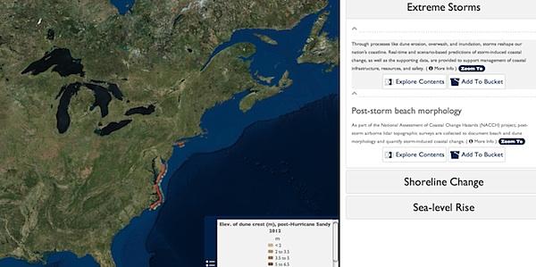
The USGS Coastal Change Hazards Portal helps gauge storm and sea-level change impacts to coastal areas./USGS
With hurricane season upon us, what are the odds that your favorite national seashore might be impacted by a Category I storm? How might sea-level rise in the years ahead affect your favorite beach? The U.S. Geological Survey has developed a tool that can give you some insights to those questions.
The tool -- the USGS Coastal Change Hazards Portal -- can also provide a look at your beach from 50, 100, or 150 years ago. Since more than 40 percent of the nation's population lives in coastal counties on both the East and West coasts, answering questions like these will help protect millions of citizens who are at risk from changing sea level, retreating shorelines, and extreme coastal storms, the agency says.
This tool runs on web browsers, tablets, and smartphones. It is designed for a wide-range of audiences, from federal and state agencies to non-governmental organizations, public entities, and private citizens. You can zoom in to your favorite national seashore with it, even zoom down to your favorite beach and see how storms might affect it.
'Our nation's coastlines are constantly changing landscapes that pose unique management challenges,' said Suzette Kimball, USGS acting director. 'This new USGS portal is truly one-of-a-kind, providing a credible foundation for making decisions to protect resources, reduce risk, and prevent economic losses.
'Essentially, the portal is an interactive mapping product with layers of information, but don't let that simple explanation be deceiving,' she said. 'The portal is unique in that it compiles a diverse array of science ' science that is unbiased ' to provide a comprehensive picture needed to visualize and understand how coasts behave under various conditions.'
How It Works
One key component of the portal is the ability to explore coastal hazard risks at varied scales, from a local area of interest to a national perspective. This location-specific capability is extremely valuable for planning and preparedness and for making decisions to build coastal resilience.
For example, if a hurricane alert is issued, users can input their city and state to see maps and imagery of potential impacts for a similar storm scenario. If an individual is planning to move to a beach, they can type a location into the portal to view what types of coastal hazards and impacts have occurred nearby. The Coastal Vulnerability Index feature shows the relative susceptibility of the Nation's coasts to sea- level rise. Resource managers can also make decisions on how best to protect precious ecosystems. These are just a few ways the portal may be utilized.
Video Tutorial
Watch a short video that demonstrates how a resident in Rodanthe, North Carolina, can use the portal to answer the question: As a long-term resident in this coastal community on the Outer Banks, how much beach erosion is occurring in my community?
Technology Sets Sail -- New 'Mashup' Capabilities
A range of information is provided through the portal, such as historical data, existing publications, satellite imagery, maps, and more. This 'mashup' of information is possible due to the wide scope of USGS expertise. For example, USGS scientists have completed a national research project that measures and interprets coastline change from the past 150-plus years. By looking to the past, scientists have direct evidence of how our diverse shorelines have behaved, allowing for more accurate analyses of future change. The USGS also investigates coastal change during extreme storms to help understand hazards such as severe beach erosion, island overwash, or coastal inundation. The portal will enable users to view USGS science in conjunction with their own personalized data to answer specific questions.
Partnerships are Essential
The maintenance of an accurate and up-to-date portal relies on relationships with federal agencies and many non-governmental organizations. This cooperation includes, for example, the incorporation of current forecasts from the National Weather Service along with corresponding coastal change forecasts from the USGS, a key partnership that will help in achieving near-real-time predictions of coastal change when hurricanes approach.
Similar collaborations are also necessary to make sure the portal addresses the needs of information users. For example, refuge managers at the U.S. Fish and Wildlife Service will be able to use this tool in combination with many of their own mapping products to develop an appropriate forecast for endangered species and resource management. Managers with the National Park Service can apply these data to evaluate how to reduce or prevent vulnerabilities at specific facilities or cultural resources due to exposure to coastal hazards.
The information provided through the portal also enables state agencies to improve their ability to monitor and assess their coastlines. 'The ability to easily locate and access USGS research and data through the new Coastal Change Hazards Portal is of great value for coastal managers,' said Massachusetts Office of Coastal Zone Management Director Bruce Carlisle. 'This information directly supports our work with local cities and towns to assess risk and communicate current and future hazards.'
Future Portal Plans and Enhancements
Coastlines are constantly changing landscapes that pose unique management challenges requiring fresh information. The USGS Coastal Change Hazards Portal is designed to be continually updated with the most current catalogues of information and tools that can be used to evaluate risk and inform actions that lead to improved coastal resilience.
In the future, the portal will evolve into an even more advanced web tool to forecast shoreline variations and provide managers and planners with information they need to protect resources, reduce risk, and prevent economic losses. Future refinements will sharpen information to the highest resolution available and provide capabilities for real-time storm vulnerability assessments.


Add comment