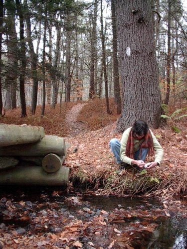
Though in remarkably good shape considering its age, the Appalachian Trail is not without its threats. Monitoring of its resources, such as water as this photo illustrates, are critical both to keep an eye on the pulse of the AT and to preserve it for future generations. NPS photo.
The focus of many long-distance hikers' dreams, the Appalachian National Scenic Trail can be a lifelong, end-to-end goal ... or a weekend outing. It knits together a slice of Americana as well as a society of nomads who set off in search of adventure.
But this well-traveled footpath, revered though it might be, is facing pressures that threaten its character and its place in the country's recreational landscape. Transmission corridors threaten to bisect the AT in places, urban sprawl is squeezing the 2,178-mile corridor in others, and incompatible uses are tearing at it, according to a report from the National Parks Conservation Association:
The narrow, linear nature of the trail corridor, coupled with its prime location along the crest of the Appalachian Mountains, leaves it susceptible to an array of development threats, such as pipelines, power lines, racetracks, quarries, residences, and energy-producing wind turbines. Increasing motorized off-road vehicle and mountain bike use along the narrow boundaries of the A.T. also represents a perennial challenge that threatens both natural and cultural resources, as well as the visitor experience.
And yet, the report (attached below) issued today in Harpers Ferry, West Virginia, home of the Appalachian Trail Conservancy as well as the National Park Service's Appalachian Trail headquarters, also offers optimism for the trail's future. All but about 10 miles of the 2,178-mile footpath are publicly owned, so protection of a great majority of the corridor that passes through 14 states as it meanders between Maine and Georgia is assured. Adding those remaining miles, which are divided into about 150 properties, would bolster that protection.
“It’s incredible that we’ve managed to put almost all of it into public ownership. At one point, 800 miles of this trail was in private lands," said Ron Tipton, NPCA's senior vice president for programs, in explaining the impetus behind the report. "But at the same time, especially in states like central Virginia north all the way up to Connecticut, this trail, its corridor is pretty narrow and it’s extremely vulnerable to multiple types of adjacent land development. We wanted to highlight the value of this place, but also highlight the threats, the potential threats, the possible degradation that could occur.”
For instance, he noted, some years ago there was a move in southeastern Pennsylvania to locate a race car track "within 500 feet of the trail."
"Southern Pennsylvania is heavily developed in small towns, and cities and little state parks here and there, and the trail kind of links through this," Mr. Tipton said. "Well, that was a major fight. All the permits were approved, and the trail community and the ATC (Appalachian Trail Conservancy) were able to generate enough public opposition that they managed to stop the project."
Not only that, he continued, but the state's legislature required that an approval process be followed for any future project that would intrude upon the trail corridor.
The NPCA report, along with calling for the remaining 10 miles of private lands to be acquired, recommends the addition of some private lands surrounding the existing corridor for the cultural or natural resource significance they would bring to the trail.
One such area that slowly is being brought into public ownership is a 10,000-acre swath near Rocky Fork in northeastern Tennessee above Great Smoky Mountains National Park. Once envisioned as a sprawling development of large-tract homesteads, the land was purchased by the Conservation Fund, which is selling it back to the U.S. Forest Service piece by piece for $43 million as funding is available.
"We’ve had about three appropriations now, and both we and the Conservation Fund are seeking kind of the final installment funding, if you will, in the upcoming fiscal year, FY11, to complete the project," said Dave Startzell, executive director of the ATC that works with the Park Service and 30 trail-maintaining clubs to care for and protect the trail. "But a good bit of the land has already been transferred to the Forest Service. I think there’s still about 2,600 acres remaining to be transferred. That’s an awesome property. I’ve been on it a number of times. Sixteen miles of blue-ribbon, high-quality native trout habitat, spectacular highlands, it’s just a terrific property."
Once all the land has been turned over to the Forest Service, the ATC plans to reroute the Appalachian Trail through it for about 3 miles.
"Currently, the footpath is sort of along the southern boundary of the property," Mr. Startzell explained. "But once the lands are transferred we’ll eventually reroute the trail to higher elevation portions of the property."
Another important section crosses South Mountain in Maryland, said Mr. Tipton, who in 1978 hiked the AT end-to-end.
"The trail comes out of Harpers Ferry and goes north and follows the crest of South Mountain pretty much," he said. "There are still private lands at the foot of the mountain that are supposed to be acquired. If not, you’re going to get subdivision creep right up onto, not on top of the ridge but right up the ridge.
"That South Mountain was a major Civil War battlefield for, probably off and on, from 1862 to 1863. And you can still see where the guns were placed," Mr. Tipton continued. "As you’re hiking along this, looking down at these fields and forests and looking up north towards Gettysburg, you’re right in the middle of where the Civil War was fought, and the pivotal battles took place. Antietam isn’t that far from the trail.”
Renowned for its long history and the journey it takes hikers on, the AT over the years has wiggled and stretched a little bit as land acquisitions and re-routing were accomplished. Three decades of land acquisitions, for example, have moved the trail off road shoulders in New Jersey and New York and up into the highlands of the region, said Mr. Startzell.
"When I started here in 1978, about 800 miles of the trail were either on private lands or on road shoulders, and that was certainly the case in New Jersey," he said. “At this point, fewer than ten miles of right-of-way remain to be acquired, and along the way we’ve actually relocated almost half of the length of the trail. In a lot of those cases the route of the trail is actually improved greatly. You can walk the New Jersey or the New York sections of the trail now and be in a pretty nice setting.
“And in fact, that’s why the length of the trail has actually increased over those years, probably by about 25 miles," Mr. Startzell added. "In a lot of cases we removed the trail from road shoulders and it's now along the ridgelines. And so it’s gotten longer, better, and in some cases more challenging to walk.”
The NPCA report notes that the AT is eligible for listing in the National Register of Historic Places. Doing so would heighten the trail's visibility and possibly help attract more funding for its protection, notes the report.
The National Park Service and the Appalachian Trail Conservancy have developed programs such as A Trail to Every Classroom and the Community Partners Program to raise "awareness of and appreciation for the A.T. as a resource that is a part of community history and contributes to the quality of life of the people and communities through which it passes," the report notes.
Though viewed as a simple footpath, the AT and its embracing corridor are much more than that, as this protected landscape also serves as a rich reservoir of life and, in some cases, offers perhaps the last toehold for many species. Within the corridor researchers already have discovered more than 2,000 "rare plant and animal species and communities. Populations of six threatened or endangered and 360 individual state-listed rare species of plants were among those documented," notes the NPCA report. "More than 80 globally rare plant community types have been identified to date on the trail, including red spruce/Fraser fir forest and Southern Appalachian mountain bogs—two of the most endangered ecosystems in the United States."
Beyond serving as a sanctuary for such plant and wildlife, trail also is an environmental indicator of conditions, and as such monitoring needs to go on.
Regularly monitoring natural resources is critical to detect trends that could be occurring over time, such as changes in species distributions or even disappearance of some species. However, establishing a comprehensive natural resources monitoring program is difficult, largely due to the trail’s exceptional length. Currently there are more than 50 volunteer-based natural-heritage monitoring sites located within all 14 A.T. states.
Along the Appalachian Trail, the Northeast Temperate Network of the National Park Service’s Inventory and Monitoring Program coordinates some natural resources monitoring, such as air quality, water quality, forest health, migratory breeding birds, atmospheric deposition, invasive species, visitor usage, alpine and high elevation vegetation, and ozone. A.T. managers also rely on citizen scientists and hikers to gather data to complement the information collected by formal resource monitoring programs. Because data collection standards may vary among individuals, using these data to make management decisions can be problematic. In an effort to standardize data collection, there are efforts under way to develop data-collection protocols for use by citizen scientists.
To ignore the science that can be gleaned from studying and observing life along the corridor would be a mistake.
To better protect and enhance the AT, the NPCA's report recommends the following:
* Increase funding to pay for natural and cultural resource inventories, strengthen interpretation, and pursue listing on the National Register of Historic Places.
* Buy up the private properties along that 10-mile stretch that is not publicly owned.
* Add high-priority lands that line the trail in places to better protect natural and cultural resources significant to the footpath.
* Continue to oppose projects, such as transmission corridors, wind farms, and wireless transmission towers, that would threaten the integrity of the AT.
For a look at an interesting interactive map that points to some of the issues facing the Appalachian Trail, check out this NPCA site: http://www.npca.org/stateoftheparks/appalachian/map/
Story Categories:
A copy of National Parks Traveler's financial statements may be obtained by sending a stamped, self-addressed envelope to: National Parks Traveler, P.O. Box 980452, Park City, Utah 84098. National Parks Traveler was formed in the state of Utah for the purpose of informing and educating about national parks and protected areas.
Residents of the following states may obtain a copy of our financial and additional information as stated below:
- Florida: A COPY OF THE OFFICIAL REGISTRATION AND FINANCIAL INFORMATION FOR NATIONAL PARKS TRAVELER, (REGISTRATION NO. CH 51659), MAY BE OBTAINED FROM THE DIVISION OF CONSUMER SERVICES BY CALLING 800-435-7352 OR VISITING THEIR WEBSITE. REGISTRATION DOES NOT IMPLY ENDORSEMENT, APPROVAL, OR RECOMMENDATION BY THE STATE.
- Georgia: A full and fair description of the programs and financial statement summary of National Parks Traveler is available upon request at the office and phone number indicated above.
- Maryland: Documents and information submitted under the Maryland Solicitations Act are also available, for the cost of postage and copies, from the Secretary of State, State House, Annapolis, MD 21401 (410-974-5534).
- North Carolina: Financial information about this organization and a copy of its license are available from the State Solicitation Licensing Branch at 888-830-4989 or 919-807-2214. The license is not an endorsement by the State.
- Pennsylvania: The official registration and financial information of National Parks Traveler may be obtained from the Pennsylvania Department of State by calling 800-732-0999. Registration does not imply endorsement.
- Virginia: Financial statements are available from the Virginia Department of Agriculture and Consumer Services, 102 Governor Street, Richmond, Virginia 23219.
- Washington: National Parks Traveler is registered with Washington State’s Charities Program as required by law and additional information is available by calling 800-332-4483 or visiting www.sos.wa.gov/charities, or on file at Charities Division, Office of the Secretary of State, State of Washington, Olympia, WA 98504.
INN Member

The easiest way to explore RV-friendly National Park campgrounds.

Here’s the definitive guide to National Park System campgrounds where RVers can park their rigs.
Our app is packed with RVing- specific details on more than 250 campgrounds in more than 70 national parks.
You’ll also find stories about RVing in the parks, tips helpful if you’ve just recently become an RVer, and useful planning suggestions.

Comments
As someone who maintains multi-use trail networks in NJ, I can appreciate the challenge that the AT trail must present. Its a monumental task due to its shear size and complexity due to the associated groups being responsible for sections throughout.
That said I don't understand your statement:
"...mountain bike use along the narrow boundaries of the A.T. also represents a perennial challenge that threatens both natural and cultural resources"
First of all I am not advocating that the AT be changed to allow mountain bikes. Its a historical trail with a certain mystique and I favor it remaining foot traffic even though I do mountain bike. Second, I understand that some mountain bikers venture onto the AT trail and ride against the trail designation, which I don't advocate and I condemn.
However, to lump mountain biking in with motorized vehicles and claim that mountain biking threatens natural and cultural resources is not backed up by reality nor by science. Its not the mountain bike that causes impact, its fall line trails and water that erodes trails. In fact if you review Jeffrey Marion's study, he found that impact is similar for hiking and biking. In fact, trails tend to be narrower where bikes are predominant because foot traffic is not always single file and its not always on-trail.
So, I would ask that unless you see that mountain bikes are causing impact on correctly built trails that have been built sustainably, I would like you to remove the reference to mountain bikers. We are not ATVs, we are not motorized vehicles. We are human powered low impact users that tend to be the nicest people on trail. We also do an enormous amount of trailwork nationwide. Please consider that next time when you put fingers to keyboard and claim that our usergroup is causing this sort of negative impact.
Jeff Mergler
www.JORBA.org
Jeff,
Don't blame the messenger. The comment pertaining to mountain bikes was included in NPCA's report, it was not my observation.
That said, I'm not familiar with Mr. Marion's study. Perhaps you could provide a link to it.
Beyond that, regarding your comment that "unless you see that mountain bikes are causing impact on correctly built trails....", are you suggesting that all hiking trails be rebuilt to handle mountain bike traffic and wear-and-tear? Here in Park City, Utah, a mountain biking mecca or sorts, there are dual-use trails threading throughout the mountains, and a problem I've encountered are narrow, v-shaped sections of trail from heavy bike use. Hikers simply can't beat those back down to relatively flat stretches. Would the entire trailbed need to be reconstructed to alleviate this problem?
Addendum: I would agree that hikers can cause quite a bit of trail damage, particularly in the first few hundred yards or so from trailheads where they fan out and walk side-by-side and so create numerous trails.