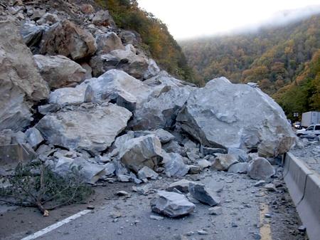
It could take three months or longer to clean up a rock slide and reopen a section of Interstate 40 on the North Carolina side of Great Smoky Mountains National Park. That means getting to the park from some areas will be a bit tricky. It also means don't rely on your GPS units to find a shortcut, as that could spell trouble.
The slide early Sunday morning dumped tons of rocks on the interstate at mile marker 2.6 in North Carolina, near the Tennessee state line, and forced closure of the interstate between Exit 20 in North Carolina and Exit 451 in Tennessee, according to the North Carolina Department of Transportation. A detour set up by the department calls for motorists traveling west to Tennessee to take I-40 West to I-240 West in Asheville, North Carolina, and then to I-26 West. You then should follow I-26 West from Asheville to I-81 South in Tennessee, back to I-40. Eastbound motorists will follow the reverse directions.
At Great Smoky, spokesman Bob Miller says they have been stressing that U.S. 441 -- the Newfound Gap Road -- is not open to commercial vehicles, but other motorists can use it to go between the two states.
"We also strongly discourage people from exiting at NC Exit 20 and going into Cataloochee and then on into Tennessee on Old 284 Cataloochee Turnpike, which is a very low standard gravel road about 1 1/2 lanes wide and wicked curvy - that road cannot serve as an alternate for any great amount of traffic," said Mr. Miller, who adds that, "Unfortunately in these days of GPS in cars a lot of people can see it on their GPS and it looks like a short-cut around the I-40 closure but have no idea just how primitive it is."
As for cleaning up the slide, the North Carolina DOT has outlined the following approach:
Phase 1
• Rock in the lower and middle sections of the slide that is still unstable will be removed.
• Large boulders that fell will be blasted into smaller pieces.Phase 2
• The rocks removed from the side of the mountain and the pieces of blasted boulders will be used to construct a ramp that will enable specialty equipment to “climb” to the top of the slide area using a pulley system. Specialty equipment is en route from New York (for photos, please click on the attachments below).Phase 3
• Crews will begin removing rock from the top down to the bottom and stabilizing the
slope. This work involves chiseling off rock (on a smaller scale, this is like using a hammer and pry bar) and blasting to stabilize the area. As crews work down the slope, experts will analyze each boulder to determine whether it is secure or should be removed. The area above the top of the slide will also be stabilized.Once all debris is cleared, temporary asphalt will be laid on the highway so that traffic can be restored until permanent asphalt can be laid in the spring.
According to the department, "the slide is about 150 feet high and 200-300 feet wide and the majority of debris is rock. Because of safety concerns while work is taking place, travel lanes will likely not open until all work is completed, which is expected to take about three months. Estimated cost is $2 million to $10 million. Time and cost estimates will be revised throughout the work."
Additionally, "geotechnical scientists and engineers do not know the exact cause of the slide, but are looking at several potential factors, including possible tremors; freezing and thawing of water in cracks in a wedge in the slope, causing expansion and contraction of the rock plates," the department said.


Comments
I posted on here a few weeks ago that we would be going to Great Smoky Mountains for our honeymoon. We enjoyed our visit, but spent a lot of time one day in slow-crawling traffic on the Newfound Gap Road due to other drivers stopping to look for bears, which caused a miles-long traffic jam. It was very busy of course due to the great fall foliage, but this bear-peeping was one aspect we didn't really anticipate. The other downside was that we both came down with the flu and didn't get to do any hiking as a result of lack of energy. Well, they say after all, "in sickness and in health....."
We thought we might make it over to Asheville, but (as per above) we didn't. And it is a good thing, too, with the referenced rockslide. It would have been a serious headache, and I was dealing with a smaller one already! ; )
We plan to go back sometime in the future - just maybe during another season. The park was beautiful and it is close enough to our home here in St. Louis to be accessible.