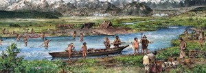
Long before Europeans reached this part of the world it was inhabited by Tlingit Indians, who had fishing camps set up on the shores of various inlets. While a glacial push about 300 years ago shoved many of these villages off the landscape, National Park Service historians note that "native people carried on their activities in many places along the nearby coast, places that may have been free of ice for as long as 13,000 years."
Tlingit fishing camp. NPS graphic.
"The oldest known site in Glacier Bay National Park, located in Dundas Bay, is about 800 years old," they tell us. "Natives were at Lituya Bay, on the park’s wild outer coast, to greet (French explorer Jean François de Galaup) Lapérouse in 1786. Although a series of earthquake-triggered tidal waves, the latest in 1959, devastated most of the shoreline of Lituya Bay, a pocket of undisturbed forest still harbors archeological evidence of their life there."
The landscape that was to become Glacier Bay National Park and Preserve was ice-capped when European explorers first reached this corner of the world. When Capt. James Cook visited the area in 1778, the Grand Pacific Glacier ran past present-day Bartlett Cove and out past Point Carolus and Point Gustavus almost into Icy Strait.
Sixteen years later the ice had ebbed a bit. When Capt. George Vancouver visited the area in 1794, the Grand Pacific Glacier had backed up to Bartlett Cove, where park headquarters and the Glacier Bay Lodge are located today.
John Muir made his first visit to the region in 1879, traveling by canoe with the Rev. S. Hall Young and guided by four Tlingit Indians. Glaciers restricted his foray into the landscape to the area around today's Geikie Inlet, though when he returned in 1890 he was able to make it a bit farther north to the area that bears his name, Muir Point.
The renowned naturalist quickly fell in love with the landscape that would later become a national park. At one point during his first visit the usual cloud cover broke up long enough to provide Muir with a spectacular view of the Fairweather Range.
 The Muir Glacier filled the entire eastern arm of Glacier Bay in 1893. NPS photo.
"The view to the westward is bound and almost filled by the glorious Fairweather Mountains, the highest among them springing aloft in sublime beauty of nearly sixteen thousand feet, while from base to summit every peak and spire and dividing ridge of all the mighty host was spotless white, as if painted. It would seem that snow could never be made to lie on the steepest slopes and precipices unless plastered on when wet, and then frozen. ... In the evening, after witnessing the unveiling of the majestic peaks and glaciers and their baptism in the down-pouring sunbeams, it seemed inconceivable that nature could have anything finer to show us," he wrote in Travels in Alaska, which was published in 1915.
Pioneer ecologist William S. Cooper of the University of Minnesota conducted studies of plant succession beginning in 1916, and was instrumental in the move to have the area protected.
The "preserve" portion of the park covers a tiny portion of the overall park, just 58,406 acres (23,636 hectares), and it's located in the extreme northwestern corner. Here hunting and trapping are permitted. Glacier Bay National Preserve is accessed by air, and involves a 50-mile (80.5-km) air taxi flight from Yakutat. There are no scheduled flights
When President Calvin Coolidge in 1925 signed the legislation that created Glacier Bay National Monument, he noted not only the tidewater glaciers and range of forests, but the "unique opportunity for the scientific study of glacial behavior and resulting movements and developments of flora and fauna and of certain valuable relics of interglacial forests."
That declaration, with its specific emphasis on the science that could be performed in Glacier Bay, continues to guide the park's research efforts to this day.
In 1939 President Franklin D. Roosevelt more than doubled the size of the monument, and in 1980 President Carter protected more lands when he signed the Alaska National Interest Lands Conservation Act, which also renamed the unit to Glacier Bay National Park and Preserve.
- By Kurt Repanshek - August 19th, 2024 5:37am


