While Glen Canyon National Recreation Area (NRA) in Arizona and Utah is known for Lake Powell, boating, and other water sports, there are land-based activities you enjoy as well, such as hiking.
There are trails to hike into the side canyons and over slickrock where you can explore isolated hanging gardens, slot canyons, and iconic geologic features such as Horseshoe Bend. You can walk a short distance of 940 feet (286 meters) for a good stretch of the legs, spend an entire day hiking a trail with roundtrip distances ranging from 1.5 miles (2.4 kilometers) up to 14 miles (22.5 kilometers), or even embark on a multi-day backpacking adventure into the backcountry. From short to long, these hiking trails are packed with stunning landscape vistas.
Day Hikes
Below are quick rundown of hikes to be enjoyed in various areas of Glen Canyon NRA. For more detailed information and directions to these trails, click on the Day Hike link above.
Page/Wahweap Area
Horseshoe Bend
Distance Roundtrip: 1.5 miles (2.4 kilometers)
Difficulty: Easy
This is a hardened accessible trail to an overlook of one of the most iconic features at Glen Canyon NRA. While there is railing at the edge of the viewing platform, much of the rim remains exposed to the 1000-foot drop, so watch your footing and keep track of your children and pets.
Note: There is a non-NPS fee required when parking at Horseshoe Bend.
Dam Overlook
Distance Roundtrip: 940 feet (286 meters)
Difficulty: Easy
The trail leads down steep, uneven rocky steps to views of Glen Canyon Dam and the Colorado River.
Beehives
Distance Roundtrip: varies
Difficulty: Easy
So named for the rock formations reminiscent of beehives, you will be hiking over slickrock formations that some people have called a “mini wave.”
Stud Horse Trail
Distance Roundtrip: varies
Difficulty: Easy
Hike as little or as much as you wish on this 6.5-mile (10.4 kilometers) network of trails populated with large hoodoos and distant views of Lake Powell and Skylight Arch.
Note: High-clearance vehicles are recommended
Winegrass Canyon
Distance Roundtrip: 6 miles (9.7 kilometers)
Difficulty: Easy
This sandy wash takes you through a small canyon and requires some scrambling and detours. Look for cairns (small stacks of rocks that act as trail markers) to lead you out. Wayfinding required.
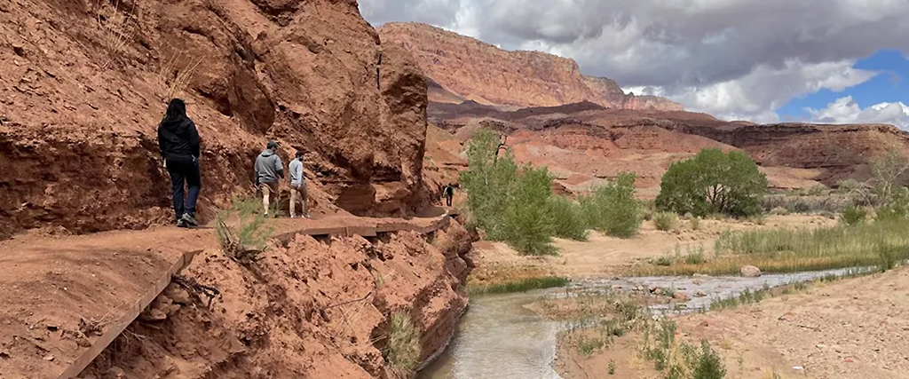
Vermilion View Trail
Distance Roundtrip: 14 miles (22.5 kilometers)
Difficulty: Moderate
This trail takes visitors along a canyon edge trail, approximately 7.5 miles and 700 feet above the Colorado River.
Hanging Gardens
Distance Roundtrip: 1.5 miles (2.4 kilometers)
Difficulty: Moderate
Hike to a seep spring feeding bright green vegetation among red rock formations.
The Chains
Distance Roundtrip: varies
Difficulty: Easy/Moderate
Here’s another hike you can make as long or short as you wish. Here, you’ll hike along slickrock formations with great views of Lake Powell and Glen Canyon Dam, as well as the chain of buoys behind the dam stationed there to keep boats away from the dam.
Lees Ferry Area

Lonely Dell Ranch
Distance Roundtrip: 1 mile (1.6 kilometers)
Difficulty: Easy
In 1870, Mormon pioneer and leader John D. Lee was sent to establish a ferry crossing. A practicing polygamist, Lee built a ranch with homes for two of his families, as well as established an orchard and irrigation system. He named this property Lonely Dell Ranch because of its remote location and you can hike an easy trail to see this historic site.
River Trail
Distance Roundtrip: 3 miles (4.8 kilometers)
Difficulty: Easy
The self-guided walking tour follows the trail along the river front of Lees Ferry.
Cathedral Wash
Distance Roundtrip: 3 miles (4.8 kilometers)
Difficulty: Moderate
Canyon walls rise as you follow a mostly dry wash to the Colorado River. Some rock scrambling and wayfinding required.
Spencer Trail
Distance Roundtrip: 4.4 miles (7 kilometers)
Elevation Gain: 1,700 feet (518.2 meters)
Difficulty: Strenuous
A short but strenuous hike with amazing views of the Colorado River and the City of Page, this rocky climb up switchbacks ascends out of the canyon surrounding Lees Ferry. The best times to hike this trail are spring and autumn.
Bullfrog Area
Red Wash Hike
Distance Roundtrip: 1 mile (1.6 kilometers)
Difficulty: Easy
A sandy hike that involves rock scrambling to lead in and out of the wash. Great beginner trail that illustrates how the power of water formed much of the local landscape. Be prepared to get muddy and wet. Do not hike when there is a potential for flash flooding.
Bullfrog Campground Hike
Distance One-Way: 1.5 miles (2 kilometers)
Difficulty: Easy
A fun trail to acclimate for longer desert excursions. Slight elevation gains allow for great views of Bullfrog Marina, Halls Crossing, Navajo Mountain and the Waterpocket Fold. Some areas the requires a small amount of steep rock scrambling. Use caution. Do not hike when there is a potential for flash flooding.
Defiance House ( Accessible by Boat ONLY)
Distance One-Way: 1 mile (1.6 kilometers) distance varies with changing lake levels
Difficulty: Easy
Boat into Forgotten Canyon as far as lake levels allow. Some wayfinding through a sandy wash may be necessary to find the trail. Keep an eye on the cliff to your left to spot the pictographs that inspired the name. There are steps leading up to the 800 year old archeological site. Visit With Respect. The structures are made of local materials and mortar that can easily be damaged. Pets are not allowed in the site.
Pedestal Alley Hike
Distance Roundtrip: 3 miles (4.8 kilometers)
Difficulty: Moderate
Experience towering rock sculptures as red canyon walls surround a hike not heavily traveled. Follow along the wash approximately 1 mi (1.6 km) until rock formations appear in the distance. Do not hike when there is a potential for flash flooding.
Escalante
These hikes are all accessed off Hole-in-the-Rock Road, a rough, unpaved road that requires high-clearance vehicles. Check road conditions before heading to the trailhead.
Dance Hall Rock
Distance Roundtrip: 3 miles (4.8 kilometers)
Difficulty: Easy
Hike at your leisure over sandy/rocky terrain into a natural red rock amphitheater.
Devil’s Garden
Distance Roundtrip: 1 mile (1.6 kilometers)
Difficulty: Easy
Hike at leisure over sandy/rocky terrain among hoodoos and arches. On the Hole-in-the-Rock Road 13 miles south from Highway 12, turn right at the sign for Devil's Garden. Continue 1.5 miles to the parking area. Picnic tables, grills, and pit toilets provided by BLM. No overnight camping.
Coyote Gulch
Distance Varies
Difficulty: Moderate
Nestled in the heart of Escalante’s canyon country, Coyote Gulch contains two arches, a natural bridge, and several waterfalls. It’s one of the most popular backpacking destinations in the Escalante. Day use does not require a permit, but please sign the trail register.
Regional Hikes
These hikes are located near or adjacent to Glen Canyon National Recreation Area. The trails offer a mix of difficulty levels. Some trails require permits of a tour guide because they are located on BLM land, Vermilion Cliffs National Monument, or Navajo Nation Tribal Parks. You can read more about these regional hikes by clicking on the Day Hikes link at the top of this page.
- By Rebecca Latson - September 12th, 2025 9:59am


