
Editor's note: This updates with closures at Assateague Island National Seashore and Tropical Storm Warning issued for Cape Hatteras and Cape Lookout national seashores.
Though hundreds of miles off the Outer Banks of North Carolina, Hurricane Erin was whipping into a furious tempest threatening to inundate Cape Hatteras and Cape Lookout national seashores this week with towering waves and floodwaters.
Risks to human life posed by the storm that wasn't expected to get closer than 150 miles to land prompted Assateague Island National Seashore in Virginia and Maryland on Tuesday to close the oversand vehicle areas in both states, close all oceanside beaches due to dangerous rip currents, and close at least some of the parking lots at the Chincoteague Beach.
The greatest risks, as of Wednesday morning, posed by the lumbering storm were for Cape Hatteras and Cape Lookout on the Outer Banks of North Carolina, which were under both a tropical storm warning and a storm surge warning.
Predictions of breakers 20 feet tall and storm surges that could rearrange the barrier islands the two seashores stand upon were in the rearview mirrors of thousands fleeing Cape Hatteras on Monday in response to a mandatory evacuation order issued by two North Carolina counties, Dare and Hyde. Highway 12, a thin ribbon of asphalt that runs the length of Cape Hatteras, is expected to once again face the ocean's wrath.
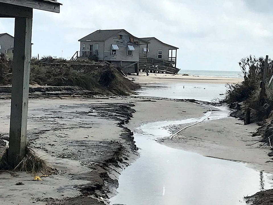
"I wouldn't be surprised to see a few more houses go (into the ocean) in Rodanthe and maybe even in Buxton," said Robert Young, director of Western Carolina University's Program for the Study of Developed Shorelines, referring to vacation homes that years of coastal erosion have placed in precarious position on the surf line.
"The problem with Hatteras is that we can't allow it to breathe and move in the same way that we can allow Cape Lookout to move because we have Highway 12 and we have infrastructure," Young continued during a phone call Monday. "In some stretches of Cape Hatteras National Seashore there are investment homes literally right behind the strip that the park owns, which is the beach, essentially. And we have for decades now been trying to push up sand dikes in front of Highway 12. This is a part of the never-ending saga of trying to maintain a transportation corridor on one of the country's most exposed barrier islands."
While the exact track of Erin is uncertain for later this week, the National Hurricane Center has predicted flooding across the Outer Banks beginning late Wednesday. A storm surge of up to four feet was predicted from the northern tip of Cape Lookout National Seashore north to Duck on the northern end of Cape Hatteras National Seashore.
“People should follow evacuation orders. Hurricane Erin is expected to blast parts of the Outer Banks with 60-to-80-mph wind gusts, several feet of storm surge and waves reaching 15-20 feet. Coastal flooding and surge could wash away dunes and leave roads submerged,” AccuWeather Lead Hurricane Expert Alex DaSilva warned. “These dangerous conditions could leave roads impassable for days, making rescues and evacuations nearly impossible. Some beach houses in areas battling beach erosion could be damaged or even collapse into the rough surf this week.”

Six years ago, in September of 2019, what initially appeared to be a small hurricane turned into a relative monster for the Outer Banks. Hurricane Dorian was labeled a Category 1 hurricane, but its path took it perilously close to the Outer Banks, generating a wall of water maybe 9 feet high that swept across the northern end of Cape Lookout, swamping historic Portsmouth Village and, overall, slicing up the seashore's barrier islands into islets.
The hurricane carved more than 50 breaches in Cape Lookout's three barrier islands, and while most naturally filled back in, a few remain today, said B.G. Horvat, the seashore's chief of interpretation, on Monday. While Erin is farther out to sea than Dorian was, the ranger said "it looks like a lot of the impacts will be up more near Cape Hatteras, but our northern end of the park, Portsmouth Island" could be hammered by the storm.
Cape Lookout stands out in comparison to Cape Hatteras and Cape Cod, as those two national seashores reside on barrier islands that have been heavily built out, while Lookout's barrier islands are dunes and maritime forests and a lighthouse with its adjacent keeper's house. There is no paved road running through the islands, no modern-day villages to lure tourists.
"Barrier islands are storm-adapted places," said Young. "They need storms, or at least the ecosystems that they support need storms. Take piping plovers, for example. They need un-vegetated sand flats. Storm wash-over is the best. To some degree I celebrate places like Cape Lookout because those are barrier islands that are still allowed to respond naturally to storms, to move around. Our touch there is still pretty light and so whatever happens on Cape Lookout is largely going to be what nature intends."
Stories about:
Story Categories:
A copy of National Parks Traveler's financial statements may be obtained by sending a stamped, self-addressed envelope to: National Parks Traveler, P.O. Box 980452, Park City, Utah 84098. National Parks Traveler was formed in the state of Utah for the purpose of informing and educating about national parks and protected areas.
Residents of the following states may obtain a copy of our financial and additional information as stated below:
- Florida: A COPY OF THE OFFICIAL REGISTRATION AND FINANCIAL INFORMATION FOR NATIONAL PARKS TRAVELER, (REGISTRATION NO. CH 51659), MAY BE OBTAINED FROM THE DIVISION OF CONSUMER SERVICES BY CALLING 800-435-7352 OR VISITING THEIR WEBSITE. REGISTRATION DOES NOT IMPLY ENDORSEMENT, APPROVAL, OR RECOMMENDATION BY THE STATE.
- Georgia: A full and fair description of the programs and financial statement summary of National Parks Traveler is available upon request at the office and phone number indicated above.
- Maryland: Documents and information submitted under the Maryland Solicitations Act are also available, for the cost of postage and copies, from the Secretary of State, State House, Annapolis, MD 21401 (410-974-5534).
- North Carolina: Financial information about this organization and a copy of its license are available from the State Solicitation Licensing Branch at 888-830-4989 or 919-807-2214. The license is not an endorsement by the State.
- Pennsylvania: The official registration and financial information of National Parks Traveler may be obtained from the Pennsylvania Department of State by calling 800-732-0999. Registration does not imply endorsement.
- Virginia: Financial statements are available from the Virginia Department of Agriculture and Consumer Services, 102 Governor Street, Richmond, Virginia 23219.
- Washington: National Parks Traveler is registered with Washington State’s Charities Program as required by law and additional information is available by calling 800-332-4483 or visiting www.sos.wa.gov/charities, or on file at Charities Division, Office of the Secretary of State, State of Washington, Olympia, WA 98504.

National parks and their natural resources belong to you. The National Parks Traveler works to ensure you know how these essential places are being cared for.
Sign Up For Our Weekly Newsletter
Unsubscribe at any time.
INN Member

The easiest way to explore RV-friendly National Park campgrounds.

Here’s the definitive guide to National Park System campgrounds where RVers can park their rigs.
Our app is packed with RVing- specific details on more than 250 campgrounds in more than 70 national parks.
You’ll also find stories about RVing in the parks, tips helpful if you’ve just recently become an RVer, and useful planning suggestions.
