This year marks the 40th anniversary of America's first national river, the Buffalo River in Arkansas' Ozarks.
Free-flowing for 135 miles, the Buffalo National River is a paddler's dream, offering cool, clear waters, grassy meadows grazed by elk, and cliff walls that frame the river in places.
While any year is a good one to push your canoe or kayak into this river in Arkansas' Ozarks, this year is particularly notable in that it marks the 40th anniversary of the country's first national river.
Locals say spring, with tulips, Jonquils, and Dogwoods in full bloom, is the best time to paddle the Buffalo River, particularly its upper stretch.
From Boxley on the far upper end of the Buffalo National River to Buffalo City where the river converges with the White River, the experiences are endless. Starting as just a trickle high in the Boston Mountains, the Buffalo flows east for nearly 150 miles, offering water for every level of experience. This turquoise water is inviting to say the least, with quiet, flowing water that at times reaching stages of exciting rapids.
The upper river is typically defined as running from the Upper Buffalo Wilderness to Mt. Hersey in Searcy County. This 52-mile stretch of river is normally floatable from March through June. Sometimes, depending on summer rain, on into July and August.
Here are some of the most popular floats on the upper section of the river.
• Boxley to Ponca; this 6-mile float is a paddlers delight with several class I and II stretches along the way. Plan to either take out at the Ponca low water bridge or portage your boat and continue down river. Watch on your left for the elk herd along the way just before you get to Ponca. This float can only occur after a heavy rain and is only for the very experienced paddler.
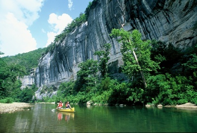
• Ponca to Steel Creek; 2.7 miles of floating bliss. Just a few rapids and several long pools. Pay attention to the huge bluffs along the left side as you approach Steel Creek. Roark Bluff is one of the most photographed on the entire river.
• Steel Creek to Kyles Landing; 8 miles of lazy water with a few rapids, passing “Big Bluff” on the left. Big Bluff is known for the Goat Trail some 500 feet above the river, and it is quite a sight! Not too far along the river is the trailhead for Hemmed-In Hollow, where you will find the tallest waterfall between the Appalachians and the Rockies. Soon you’ll pass the infamous “Gray Rock” or “Naked Lady Rock” (as locals call it) before arriving at Kyles Landing. The rock is a popular place for floaters to hang out along the river and jump off into the cool water. 300 yards of rapids will be found just before you get to the rock. Kyles Landing will be on your right.
• Kyles Landing to Erbie; 5.6 miles with a combination of slow flowing pools, mixed with faster water. Soon after launch, you will see the Boy Scout camp called Camp Orr. Erbie is a great spot to camp with a fully developed campground for singles or groups.
• Erbie to Ozark; 5.5 miles. Most floaters who put in at Erbie, will go on to Pruitt.
• Ozark to Pruitt; 2.1 miles of fairly easy water. Pass under the historic Pruitt Bridge over Scenic Highway 7 and the take-out will be on your left.
Boxley to Pruitt total mileage; 29.9 miles
Camping is permitted all along the river, with developed sites at Lost Valley, Steel Creek, Kyles Landing, Erbie and Ozark. Fees will be charged, but reservations are not required. Hiking and horseback riding trails are available all along the river via the Buffalo River Trail. Side trips are also available at Lost Valley, Hemmed-In Hollow and the Parker-Hickman Farmstead. Concessions and shuttles are available in Ponca, Marble Falls and Jasper. Always check on water levels before planning a float trip on the Buffalo National River. Flooding conditions will cause the river to be closed. Watch for signs. Check current river conditions by calling 888-692-1162 or visit this site.
Story Categories:
A copy of National Parks Traveler's financial statements may be obtained by sending a stamped, self-addressed envelope to: National Parks Traveler, P.O. Box 980452, Park City, Utah 84098. National Parks Traveler was formed in the state of Utah for the purpose of informing and educating about national parks and protected areas.
Residents of the following states may obtain a copy of our financial and additional information as stated below:
- Florida: A COPY OF THE OFFICIAL REGISTRATION AND FINANCIAL INFORMATION FOR NATIONAL PARKS TRAVELER, (REGISTRATION NO. CH 51659), MAY BE OBTAINED FROM THE DIVISION OF CONSUMER SERVICES BY CALLING 800-435-7352 OR VISITING THEIR WEBSITE. REGISTRATION DOES NOT IMPLY ENDORSEMENT, APPROVAL, OR RECOMMENDATION BY THE STATE.
- Georgia: A full and fair description of the programs and financial statement summary of National Parks Traveler is available upon request at the office and phone number indicated above.
- Maryland: Documents and information submitted under the Maryland Solicitations Act are also available, for the cost of postage and copies, from the Secretary of State, State House, Annapolis, MD 21401 (410-974-5534).
- North Carolina: Financial information about this organization and a copy of its license are available from the State Solicitation Licensing Branch at 888-830-4989 or 919-807-2214. The license is not an endorsement by the State.
- Pennsylvania: The official registration and financial information of National Parks Traveler may be obtained from the Pennsylvania Department of State by calling 800-732-0999. Registration does not imply endorsement.
- Virginia: Financial statements are available from the Virginia Department of Agriculture and Consumer Services, 102 Governor Street, Richmond, Virginia 23219.
- Washington: National Parks Traveler is registered with Washington State’s Charities Program as required by law and additional information is available by calling 800-332-4483 or visiting www.sos.wa.gov/charities, or on file at Charities Division, Office of the Secretary of State, State of Washington, Olympia, WA 98504.
INN Member

The easiest way to explore RV-friendly National Park campgrounds.

Here’s the definitive guide to National Park System campgrounds where RVers can park their rigs.
Our app is packed with RVing- specific details on more than 250 campgrounds in more than 70 national parks.
You’ll also find stories about RVing in the parks, tips helpful if you’ve just recently become an RVer, and useful planning suggestions.

Comments
I am President of the Buffalo River Chamber of Commerce. Our website is the single best guide to the Buffalo National River. We have well over a 120 pages of information about the free natural attractions and things to do. We have free river topo maps, river gauges, and extensive attraction coverage. We also cover the wild lands managed by Arkansas Game and Fish, and the Ozark National Forest. Our 150 mile long river has something for everyone.
We have a huge mobile website for smart phones.
http://buffaloriverchamber.com
http://buffaloriverchamber.mobi
The Buffalo National River has been voted one of the top ten unknown national parks that everyone must visit by AOL Travel, National Geographic and others. The park is near 20% of the US population. It is the ideal staycation location and very affordable.
Michael Dougherty, President
Buffalo River Chamber of Commerce
Looks like a great resource, Michael.
Another great resource for planning a visit to the Buffalo National River Country is www.theozarkmountains.com, the website of the Newton County, Arkansas Chamber of Commerce. Newton County is the headwaters of the Buffalo National River and is known affectionately as "Nature's Paradise" due its outstanding beauty and pristine environment.
In addition to the great canoeing and paddlesports opportunities the Buffalo National River is known for, the surrounding area is an outdoor recreation paradise with many hiking and backpacking trails, beautiful scenic drives, waterfalls, caves, horseback riding opportunities, great fishing, and outstanding watchable wildlife opportunities. In fact, Newton County is the official "Elk Capital of Arkansas" due to the successful reintroduction of elk into the national park and local area.
For more information to help you plan a visit to Newton County - Nature's Paradise & Buffalo National River Country, visit www.theozarkmountains.com or call us toll free at 1-800-670-7792.
Donnie Crain, Tourism Director/Vice President of the Newton County Chamber of Commerce
Thanks Donnie. Good to hear from your neck of the woods.
In what sense is the Buffalo (established in 1972) "America's first national river"? The Ozark National Scenic Riverways (the Current and Jacks Fork in Missouri, same length as the Buffalo) was established by Congress in 1964.
Which came first, Ozark or the Buffalo? This is a question park history buffs have to love!
I suppose which area can claim the title of America's "first national river" depends on how finely one splits the hair. That honor is often given to the Buffalo in various publications and websites.
If you want to be really technical, Ozark is a "National Scenic Riverway" while the Buffalo is a "National River," although the NPS website for Ozark notes that the area "is the first national park area to protect a river system."
According to the official National Parks Index (2009-2011), Ozark National Scenic Riverways was authorized by Congress on August. 27, 1964 – but not established until June 10, 1972.
Buffalo National River was authorized on March 1, 1972 … and there's no separate date for "establishment" for the Buffalo in that official Index.
Does that means the March 1, 1972, date applies to both steps for the Buffalo? If so, one could argue that Buffalo National River wins the debate by about 5 months in terms of which area actually existed in fact, rather than as a concept.
For anyone with way too much time on his hands, perhaps the answer to that technicality would be found by researching which site had the first piece of real estate actually transferred to NPS ownership :-)
The best news is that both areas still exist as protected free-flowing rivers, with the scenery, resources and recreational opportunities that go along with that status.