
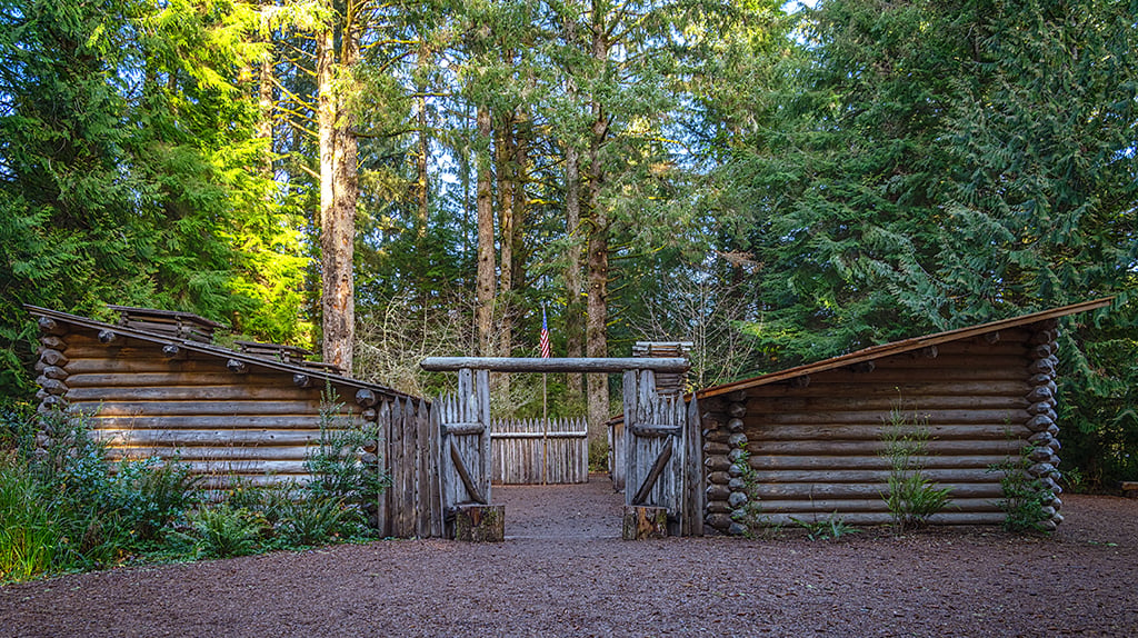
After Captains Meriwether Lewis and William Clark, along with their Corps of Discovery, finally reached the mouth of the Columbia River emptying into the Pacific Ocean, this band of men, one Native American woman (Sacagawea) and her baby, and a large Newfoundland dog named Seaman needed somewhere to rest and recuperate over the winter as well as to update maps and prepare for the long journey back to St. Louis.
Crossing the river from Washington to Oregon, the Corps of Discovery found a place to settle for the next three months. They built their winter encampment (Fort Clatsop) about two miles up the Netul River (now Lewis and Clark River) and this location is now a part of Lewis and Clark National Historical Park. Here, you can spend a day or two exploring the various units constituting this park and then, if you feel so inclined, spend another day or two retracing the Oregon/Washington route of the Lewis and Clark National Historic Trail.
The visitor center at Fort Clatsop is a great place to start. There’s a museum, a bookstore, and a couple of films to acquaint you with the park. You can get your questions answered and make use of the restroom before heading outdoors to explore the trails and a replica of the original Fort Clatsop which was built in less than a month to house 32 men, a woman, her baby, and one large dog. Depending upon when you visit, you might encounter costumed rangers demonstrating how to make candles, tan hides, and use a flintlock gun in addition to talking about life in general at the fort during the winter.
A web of trails surrounds Fort Clatsop ranging from one mile (1.61 kilometers) to 13 miles (21 kilometers) roundtrip. You can hike along the bank of the Lewis and Clark River or make the trek along the Fort to Sea Trail beginning in the woods south of Fort Clatsop and wending your way to Sunset Beach along the Pacific Ocean. As you wander the trail, you will be passing through the ancestral lands of the Clatsop Indians.

In addition to land-based hiking at this park, you can do a little paddling as well. Netul Landing is where the Corps of Discovery disembarked and built their winter fort nearby. It’s the perfect place to launch your canoe or kayak for an exploration of a part of the 146-mile (235-kilometer) Lewis and Clark Columbia River Water Trail. You can even sign up for a ranger-guided paddle tour using a park-provided kayak, paddles, and life jacket.
While Fort Clatsop is the most popular site to visit, there are other separate units comprising this national historical park which are either managed by the National Park Service or other state agencies. These non-contiguous units span a 40-mile (64.4-kilometer) stretch along the Pacific Coast in both Washington and Oregon and are worth spending time exploring.
Fort Stevens State Park (Oregon)
Seven miles (11.3 kilometers) north of the Fort Clatsop visitor center, this state park was once the site of a Clatsop settlement with eight large houses noted by Captain William Clark while passing by this area in 1805.
Sunset Beach State Recreation Area (Oregon)
Here is the western end of the Fort to Sea Trail that begins 6.5 miles (10.5 kilometers) away just outside of Fort Clatsop. This is the trail traveled by the Corps of Discovery to and from the Pacific Ocean.
Ecola State Park (Oregon)
Word got to the Corps of Discovery of a huge beached “fish” in 1806 near what is now present-day Cannon Beach. This “fish” was a 105-foot blue whale. Taking Sacagawea with them because she’d never seen the Pacific Ocean before, they found the Chinook people already processing the carcass and they traded for some of the blubber and oil. Ecola State Park is 22 miles (35.4 kilometers) south of the Fort Clatsop visitor center.

We find it easy to buy salt nowadays – from sea salt flakes to Celtic gray salt to Himalayan pink salt – but during 1806, it took more effort for Lewis, Clark, and their Corps to acquire this valuable mineral used for preserving meat. Located in Seaside, Oregon, about 15 miles (24 kilometers) away from Fort Clatsop, this is the spot where Lewis and Clark set up their salt processing camp.
Cape Disappointment State Park (Washington)
Here is the site of the expedition's exploration of the coast.
According to Park Staff:
English fur trader John Meares was mistaken as he stood on the northern shore of the mouth of the Columbia River in July 1788. He was in search of the great river, but what appeared before him seemed to be a large bay, so he named the high bluff above the Columbia’s mouth, “Cape Disappointment.”
Home to the Lewis and Clark Interpretive Center, this is where Lewis, Clark, and the Corps of Discovery first reached the Pacific Ocean in November 1805, marking the culmination of an 18-month journey over 16 states, covering 4,900 miles (7,886 kilometers).
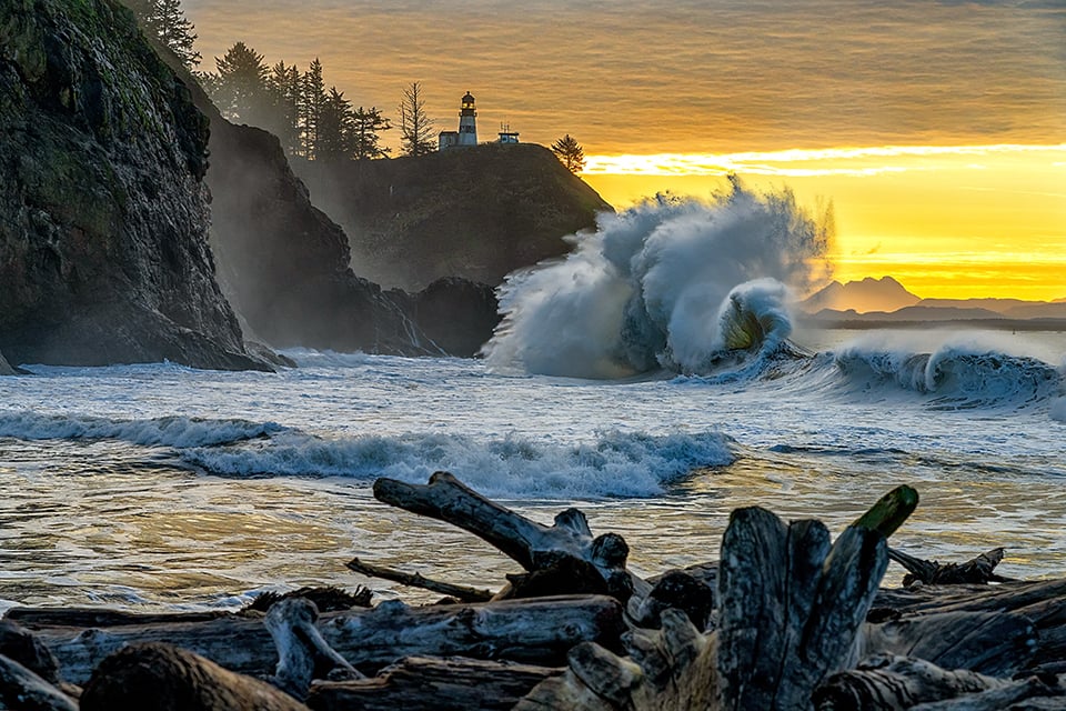
In addition to exploring the history of the Corps, Cape Disappointment is also a stellar location for photographing the annual king tides from November to January.
Fort Columbia State Park (Washington)
Thirteen miles north of the Fort Clatsop visitor center and located along the Washington side of the Columbia River, this is a site overlooking the Columbia River and through which Lewis and Clark and the Corps passed on their way to the Pacific Ocean.
Middle Village-Station Camp (Washington)

From Fort Clatsop, drive back to Astoria, Oregon, and cross the river over to the Washington side of the Columbia River. At the end of the bridge, turn left toward Middle Village, the site of a significant Chinook trade village from which archaeologists uncovered over 10,000 artifacts including beads, arrowheads, ceremonial items, and items from European and New England trade ships.
Middle Village was unoccupied at the time Lewis, Clark, and the Corps landed. They remained 10 days there, calling it “Station Camp” because it was Clark's primary survey station from where he produced one of the most detailed maps of the trip, accurately displaying the mouth of the Columbia River and surrounding area.
At this location, you will find painted replicas of Chinook canoes near St. Mary’s McGowan Church, built in 1904 and now the only remaining building marking the site of the former town of McGowan.

Imagine being soggy, cold, tired, travel worn, and hungry. A truly dismal time.
Located on the Washington State side 11.5 miles north of the Fort Clatsop visitor center, across the river from Astoria and one mile (1.61 kilometers) to the right from the Astoria-Megler Bridge, Dismal Nitch is easy to locate because of the nearby rest area and bronze monument commemorating the tribulations of the Corps of Discovery at this spot. You can walk along the roadside around the small cove where a miserable group of people spent six wet, cold winter days before they were able to resume their journey.
According to Park Staff:
A fierce winter storm forced the Corps off the river on November 10 and pinned the group to a north shore cove consisting of little more than jagged rocks and steep hillside. Captain William Clark named the dreary spot “that dismal little nitch.” For six stormy days, the group was trapped by fierce wind and high waves at the rocky shoreline. For only the second time in the expedition, Clark said he was concerned for the safety of the Corps.
In the following years this site became a fish receiving station to support a cannery operation, and later a ferry landing and train station. Eventually in 1968 and 1969 the Washington Department of Highways demolished the ferry landing and constructed the Megler Rest Area in its place. The Megler Rest Area was renamed the Dismal Nitch Rest Area in 2005.

Don’t forget to bring your binoculars or telephoto lens, because these places of historic import are also homes to 46 mammals, 100 birds, 10 amphibians, 20 fish and 3 reptiles. You might get lucky and spot a giant Pacific salamander, a herd of elk, or a barred owl.
If you choose to spend more than one day exploring the units of Lewis and Clark National Historical Park, be aware there is no camping or lodging within the park, but there are plenty of lodging and dining options in the surrounding communities, from Ilwaco on the Washington side, to the historic town of Astoria, Oregon just across the Columbia River, to the seaside towns up and down the Oregon Coast.
Traveler’s Choice For: history, photography, families
Stories about:
Story Categories:
A copy of National Parks Traveler's financial statements may be obtained by sending a stamped, self-addressed envelope to: National Parks Traveler, P.O. Box 980452, Park City, Utah 84098. National Parks Traveler was formed in the state of Utah for the purpose of informing and educating about national parks and protected areas.
Residents of the following states may obtain a copy of our financial and additional information as stated below:
- Florida: A COPY OF THE OFFICIAL REGISTRATION AND FINANCIAL INFORMATION FOR NATIONAL PARKS TRAVELER, (REGISTRATION NO. CH 51659), MAY BE OBTAINED FROM THE DIVISION OF CONSUMER SERVICES BY CALLING 800-435-7352 OR VISITING THEIR WEBSITE. REGISTRATION DOES NOT IMPLY ENDORSEMENT, APPROVAL, OR RECOMMENDATION BY THE STATE.
- Georgia: A full and fair description of the programs and financial statement summary of National Parks Traveler is available upon request at the office and phone number indicated above.
- Maryland: Documents and information submitted under the Maryland Solicitations Act are also available, for the cost of postage and copies, from the Secretary of State, State House, Annapolis, MD 21401 (410-974-5534).
- North Carolina: Financial information about this organization and a copy of its license are available from the State Solicitation Licensing Branch at 888-830-4989 or 919-807-2214. The license is not an endorsement by the State.
- Pennsylvania: The official registration and financial information of National Parks Traveler may be obtained from the Pennsylvania Department of State by calling 800-732-0999. Registration does not imply endorsement.
- Virginia: Financial statements are available from the Virginia Department of Agriculture and Consumer Services, 102 Governor Street, Richmond, Virginia 23219.
- Washington: National Parks Traveler is registered with Washington State’s Charities Program as required by law and additional information is available by calling 800-332-4483 or visiting www.sos.wa.gov/charities, or on file at Charities Division, Office of the Secretary of State, State of Washington, Olympia, WA 98504.
INN Member

The easiest way to explore RV-friendly National Park campgrounds.

Here’s the definitive guide to National Park System campgrounds where RVers can park their rigs.
Our app is packed with RVing- specific details on more than 250 campgrounds in more than 70 national parks.
You’ll also find stories about RVing in the parks, tips helpful if you’ve just recently become an RVer, and useful planning suggestions.

