
If you read the previous Throwback Thursday article, you’ll know what TBT means and why you’ll get more than just a historical photo when you come to the Traveler’s webpage. For this TBT article, it’s all about Curecanti National Recreation Area (NRA) in Colorado.
You see, before there was ever a national recreation area, before there even were reservoirs, there was a branch of the Denver & Rio Grande Western Railroad (D&RGW) and the town of Cimarron.
The Railroad
In the late 1800s there was gold in them thar hills – or rather, silver and coal around Gunnison-Crested Butte north of what is now Curecanti National Recreation Area (NRA) in Colorado. West of the NRA were the larger towns of Montrose and Grand Junction, and even further northwest of Grand Junction was Salt Lake City with its population of almost 21,000 people (and their money). The ruggedly dangerous landscape between these towns could be a very lucrative route to commerce and tourists – if a way could be found to build that route. Enter the Denver & Rio Grande Western Railroad (D&RGW) in 1881, ready and willing to take the risk and build a railroad.
At the time, the standard rail width was 4' 8 1/2", but building a standard gauge railroad through steep mountain passes and a deep, narrow canyon cost too much and would take way too long to construct. Instead, William Jackson Palmer, the engineer responsible for constructing the railroad, opted for the narrow 3’ gauge.
After the first 20 miles of construction west of Gunnison, the decision needed to be made where next to lay track. Would there be less snow and bad weather over mountains and mesas, or through the Black Canyon of the Gunnison? Laying track through the canyon was cheaper and stood a better chance of remaining snow free, so work commenced, fueled by Italian and Irish labor.
Fun fact: “Terminal cities” (aka rail stations) sprang up along the route and they all had one thing in common: plenty of saloons. These settlements were ultimately covered by the waters of Blue Mesa Reservoir decades later.
Laying track through the narrow canyon was dangerous work. Avalanches, rockfalls, drilling hazards, and the unstable explosive nitroglycerin made constructing the railroad extremely risky, with at least one explosion resulting in the death of two men.
Eventually, track was laid through the canyon, up the Cimarron River, and to the town site of Cimarron in 1882. The cost per mile to build that narrow-gauge railroad was $165,000, “equivalent in purchasing power to approximately $5.26 million today,” according to Google.
Although dangerous, with constant threat of rockfalls and avalanches during the winter, thousands of passengers bought tickets to ride this route, touted by D&RGW as the cornerstone of its "Scenic Line of the World" passenger promotions.
![]()
Cimarron grew from a tent city to a town boasting a restaurant and a hotel (along with probably more than one saloon). The town’s livelihood revolved around the trains. Eventually, the mining petered out, but stockmen took advantage of this railroad to ship cattle and sheep. It wasn’t until the early 1900s that narrow gauge track disappeared, although the D&RGW continued regular runs until freight decreased and passengers were routed north to the standard gauge track over Tennessee Pass or through the Moffat Tunnel.
Things are quieter for Cimarron in the 21st century, and this once bustling train town is now a small community with a campground, hiking trail, rail yard interpretive exhibit and truss bridge, restrooms, and picnic areas with access for boating and fishing on Crystal Reservoir, and views of Morrow Point Dam.
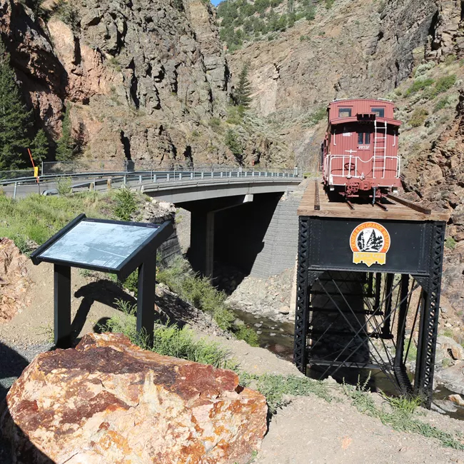
What remains of the once-busy D&RGW narrow gauge railroad is a remnant of truss bridge upon which rests Locomotive #278, retired in 1952 and given to the city of Montrose as a gift. In 1973, the locomotive, tender, and caboose were leased to the National Park Service for 20 years. In 1989, the lease was renegotiated and extended to 99 years. You can see this exhibit just outside of Cimarron, at the mouth of Cimarron Creek upstream from its confluence with the Gunnison River.
The Reservoirs

The main features of Curecanti NRA are the three reservoirs comprising the Wayne N. Aspinall Unit, a part of the Colorado River Storage Project Act authorizing comprehensive water resource development in the Upper Colorado River Basin. At the NRA, this law initiated the construction of three dams, which in turn created Blue Mesa, Morrow Point, and Crystal reservoirs.
Blue Mesa Reservoir
This reservoir is the largest of Curecanti’s reservoirs and the largest body of water in Colorado. Located west of Gunnison, Colorado. It is accessible via U.S. Highway 50 (east to west) and CO Highway 149. County Road 26 (CR-26) is an unpaved access road that intersects U.S. Highway 50 just west of the Middle Bridge.
Blue Mesa Reservoir offers the most recreational opportunities within the park:
Boating (spring, summer, and fall)
Camping (Elk Creek Campground year-round, other campgrounds seasonally)
Camping by boat (summer)
Fishing (spring, summer, and fall)
Hiking (all year)
Ice fishing, snowmobiling, and snowshoeing (winter)
Ranger programs (summer and fall)
Stargazing (all year)
NOTE: From late May to September 2026, the road to Pine Creek Trailhead will be closed to all access during road construction. There will be no access to Pine Creek Trail or the upper end of Morrow Point Reservoir during this time.
Morrow Point Reservoir
This is a remote, 12-mile-long (19.3 kilometers) fjord-like reservoir located in the upper Black Canyon of the Gunnison. Boating is limited to hand-carried craft (kayak/canoe) down the Pine Creek Trail off of U.S. Highway 50 (1 mile/1.6 kilometers) west of the highway’s junction with Colorado Highway 92. A short steep road leads to the trailhead, which consists of approximately 232 steps down into the canyon. Parking space is limited. You can see views of this reservoir from overlooks along Highway 92.
Boaters on Morrow Point Reservoir are required to fill out a free backcountry use permit. Permits are available at the Pine Creek trailhead.
Crystal Reservoir
Like Morrow Point, this remote, fjord-like reservoir is in the upper Black Canyon of the Gunnison, and boating is limited to hand-carried craft. The access trail for Crystal Reservoir is reached via the Mesa Creek Trail located near Cimarron. The trailhead is located off U.S. Highway 50, at Cimarron. Drive 1 mile (1.6 kilometers) to Morrow Point Dam parking area.
Overlooks from Crystal Creek Trail and Morrow Point Dam parking area provide views into the reservoir.
Both Morrow Point and Crystal reservoirs offer the following opportunities:
Boating – limited to hand carried craft (spring, summer, and fall)
Camping by boat (summer)
Fishing (spring, summer, and fall)
Hiking (all year)
If you think you might like to visit Curecanti National Recreation Area, check out the Traveler’s Essential Park Guide. The pages at the bottom offer suggestions, directions, and other information to help you with your plans and preparations for spending time at this park.
Stories about:
Story Categories:
A copy of National Parks Traveler's financial statements may be obtained by sending a stamped, self-addressed envelope to: National Parks Traveler, P.O. Box 980452, Park City, Utah 84098. National Parks Traveler was formed in the state of Utah for the purpose of informing and educating about national parks and protected areas.
Residents of the following states may obtain a copy of our financial and additional information as stated below:
- Florida: A COPY OF THE OFFICIAL REGISTRATION AND FINANCIAL INFORMATION FOR NATIONAL PARKS TRAVELER, (REGISTRATION NO. CH 51659), MAY BE OBTAINED FROM THE DIVISION OF CONSUMER SERVICES BY CALLING 800-435-7352 OR VISITING THEIR WEBSITE. REGISTRATION DOES NOT IMPLY ENDORSEMENT, APPROVAL, OR RECOMMENDATION BY THE STATE.
- Georgia: A full and fair description of the programs and financial statement summary of National Parks Traveler is available upon request at the office and phone number indicated above.
- Maryland: Documents and information submitted under the Maryland Solicitations Act are also available, for the cost of postage and copies, from the Secretary of State, State House, Annapolis, MD 21401 (410-974-5534).
- North Carolina: Financial information about this organization and a copy of its license are available from the State Solicitation Licensing Branch at 888-830-4989 or 919-807-2214. The license is not an endorsement by the State.
- Pennsylvania: The official registration and financial information of National Parks Traveler may be obtained from the Pennsylvania Department of State by calling 800-732-0999. Registration does not imply endorsement.
- Virginia: Financial statements are available from the Virginia Department of Agriculture and Consumer Services, 102 Governor Street, Richmond, Virginia 23219.
- Washington: National Parks Traveler is registered with Washington State’s Charities Program as required by law and additional information is available by calling 800-332-4483 or visiting www.sos.wa.gov/charities, or on file at Charities Division, Office of the Secretary of State, State of Washington, Olympia, WA 98504.
INN Member

The easiest way to explore RV-friendly National Park campgrounds.

Here’s the definitive guide to National Park System campgrounds where RVers can park their rigs.
Our app is packed with RVing- specific details on more than 250 campgrounds in more than 70 national parks.
You’ll also find stories about RVing in the parks, tips helpful if you’ve just recently become an RVer, and useful planning suggestions.
