Although there are nationally significant resources along a 50-mile stretch of the Ocmulgee River in Georgia to protect through its addition to the National Park System, the National Park Service concluded that the area poses land-acquisition challenges and could be better managed by others.
The river section in question falls between Macon and Hawkinsville.
Under the Park Service's guidelines for a Significant Resources Study, four Congressionally established criteria are examined: 1) national significance, 2) suitability, 3) feasibility, and 4) the need for NPS management. All four criteria must have positive findings at the time of the study for the SRS to positively recommend a site for potential inclusion in the National Park System.
A special resource study describes the resource conditions, and stakeholder perspectives at the time of the study. It serves as one of many reference and information sources for Congress and those interested in the potential designation of an area in the National Park System.
In this case, the NPS found that the study area is nationally significant and, based on the combination of resource values in the Ocmulgee River corridor, that the study area is suitable for inclusion in the national park system. However, the study area did not meet criterial for feasibility at the time of the study, primarily due to potential challenges of land acquisition in the large study area, a Park Service release said.
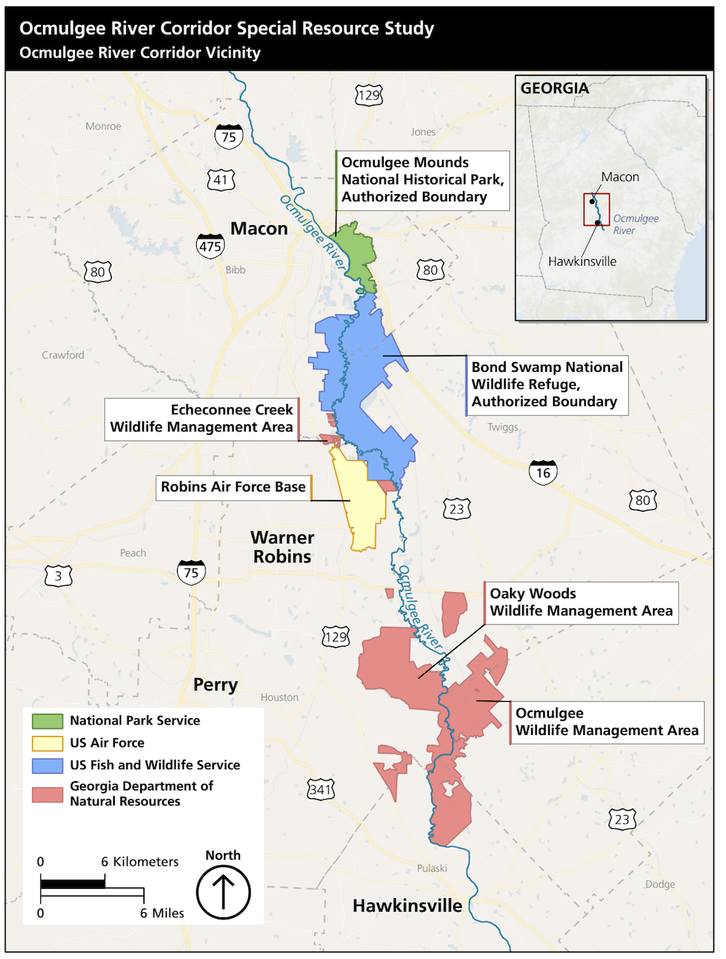
Additionally, management by the NPS does not appear to be the most efficient or necessary strategy for conserving the river corridor. Major portions of the study area are already managed for public use and conservation by the U.S. Fish and Wildlife Service and the Georgia Department of Natural Resources. In addition, the NPS already has a substantial presence on the north end of the river corridor at Ocmulgee Mounds National Historical Park.
The study identifies several opportunities for existing agencies, including the NPS, U.S. Fish and Wildlife Service and Georgia Department of Natural Resources, to partner with each other, tribal nations and private landowners to expand conservation and public enjoyment of the resources of the Ocmulgee River Corridor. In addition to partnership management, pursuing National Heritage Area, National Historic Landmark, National Natural Landmark and/or Wild and Scenic River status would provide added recognition of the area’s resources.
The Ocmulgee River Corridor includes a rich human history with archaeological resources dating from the Paleoindian Period through World War II, the release noted. Particularly significant are extensive American Indian resources, including Mississippian mound sites and sites associated with Muscogee Creek heritage and history. The river corridor is comprised mostly of bottomland hardwood forest and swamp with some upland forest in the terraces above the floodplain.
Diverse wildlife in the area includes black bears, white-tailed deer, wood ducks, alligators, wild turkeys, and many species of waterfowl. Major public land holdings in the area include Ocmulgee Mounds National Historical Park; the Bond Swamp National Wildlife Refuge; Robins Air Force Base; and the Echeconnee Creek, Oaky Woods and Ocmulgee State Wildlife Management Areas. There are also several public river landings. Much of the property in the study area is undeveloped, whether in private or public ownership.
Additions to the National Park Service system are designated by acts of Congress or through presidential proclamation. An SRS serves as one reference for consideration in the potential designation of an area to be added to the system.
You can find additional details of the study at this site.
Stories about:
Story Categories:
A copy of National Parks Traveler's financial statements may be obtained by sending a stamped, self-addressed envelope to: National Parks Traveler, P.O. Box 980452, Park City, Utah 84098. National Parks Traveler was formed in the state of Utah for the purpose of informing and educating about national parks and protected areas.
Residents of the following states may obtain a copy of our financial and additional information as stated below:
- Florida: A COPY OF THE OFFICIAL REGISTRATION AND FINANCIAL INFORMATION FOR NATIONAL PARKS TRAVELER, (REGISTRATION NO. CH 51659), MAY BE OBTAINED FROM THE DIVISION OF CONSUMER SERVICES BY CALLING 800-435-7352 OR VISITING THEIR WEBSITE. REGISTRATION DOES NOT IMPLY ENDORSEMENT, APPROVAL, OR RECOMMENDATION BY THE STATE.
- Georgia: A full and fair description of the programs and financial statement summary of National Parks Traveler is available upon request at the office and phone number indicated above.
- Maryland: Documents and information submitted under the Maryland Solicitations Act are also available, for the cost of postage and copies, from the Secretary of State, State House, Annapolis, MD 21401 (410-974-5534).
- North Carolina: Financial information about this organization and a copy of its license are available from the State Solicitation Licensing Branch at 888-830-4989 or 919-807-2214. The license is not an endorsement by the State.
- Pennsylvania: The official registration and financial information of National Parks Traveler may be obtained from the Pennsylvania Department of State by calling 800-732-0999. Registration does not imply endorsement.
- Virginia: Financial statements are available from the Virginia Department of Agriculture and Consumer Services, 102 Governor Street, Richmond, Virginia 23219.
- Washington: National Parks Traveler is registered with Washington State’s Charities Program as required by law and additional information is available by calling 800-332-4483 or visiting www.sos.wa.gov/charities, or on file at Charities Division, Office of the Secretary of State, State of Washington, Olympia, WA 98504.

National parks and their natural resources belong to you. The National Parks Traveler works to ensure you know how these essential places are being cared for.
Sign Up For Our Weekly Newsletter
Unsubscribe at any time.
INN Member

The easiest way to explore RV-friendly National Park campgrounds.

Here’s the definitive guide to National Park System campgrounds where RVers can park their rigs.
Our app is packed with RVing- specific details on more than 250 campgrounds in more than 70 national parks.
You’ll also find stories about RVing in the parks, tips helpful if you’ve just recently become an RVer, and useful planning suggestions.
