Editor's note: Volcano Watch is a weekly article and activity update written by U.S. Geological Survey Hawaiian Volcano Observatory scientists and affiliates. This article was written by Hawaiian Volcano Observatory geologist Kendra J. Lynn.
Understanding the eruptive history of volcanoes in Hawaii requires a tremendous amount of time and effort examining deposits. Typically, older eruptions have less material exposed at the surface because younger eruptions bury them, or wind and rain erode them. Such is the case for one of Kīlauea’s largest explosive eruptions, which is not exposed near its source at the summit and must be studied further afield.
Although Kīlauea is world renowned for its lava flow eruptions, it also has a history of explosive eruptions. The two most recent explosive periods, which created deposits named the Uwēkahuna Ash and Keanakāko‘i Tephra, were preceded by huge outpourings of lava. These large lava flow eruptions may have drained Kīlauea’s summit plumbing system and caused caldera collapse; subsequent activity was explosive.
Studies of the younger Keanakāko‘i Tephra (1500 to the early 1820s Common Era, or CE) have provided many key insights into Kīlauea’s evolution over the past few hundred years.
The older Uwēkahuna Ash represents possibly 1,200 years of dominantly explosive activity, yet only a few detailed geologic studies exist for these deposits. The type locality of Uwēkahuna Ash was a vertical section within the Uēkahuna bluff on the western wall of Kaluapele (Kīlauea’s summit caldera), but summit collapses in 2018 and subsequent rock falls buried this location. Fortunately, we can study samples that were collected from this location and collect new samples from the same deposits further away from the summit.
The Kulanaokuaiki Tephra is a subset of the Uwēkahuna Ash. It erupted between 400–1000 CE. HVO geologists and collaborators are focusing on one part of this deposit—named Kulanaokuaiki-3 (K-3, for short)—because it is one of the largest known explosive eruptions at Kīlauea in the past several thousand years.
K-3 explosive activity likely had an eruption column that reached 14–18 km (9–10 miles) above sea level for several hours. The K-3 plume dispersed tephra, in a southeast direction, across an area larger than 65 square km (16,000 acres), from Kīlauea’s summit all the way to Halapē on the coastline 17 km (10.5 miles) away.
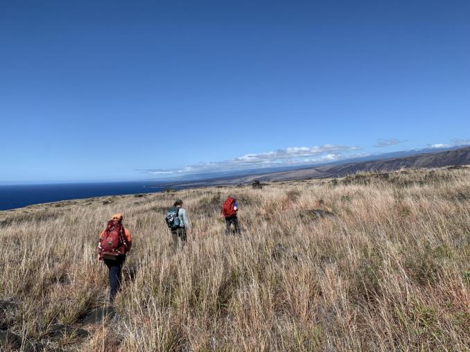
Recently, HVO scientists conducted fieldwork in the backcountry of Hawai‘i Volcanoes National Park. They focused on finding, measuring, and sampling deposits from K-3 to better understand how, when, and why eruptions of this magnitude might occur. This work was conducted under the supervision of a HAVO archaeologist, who ensured our work would not disrupt any cultural or natural resources.
In the field, HVO geologists dug small pits in soil and tephra that has accumulated in the low spots on the lava flows that cover the surface of Kīlauea’s south flank. Once exposed, the layers of soil, ash, and tephra within the pits were measured, described, and sampled.
Using these samples we’ll assess the degree of tephra fragmentation—a proxy for eruption intensity and size—by measuring the shape and size distribution of tephra grains using state-of-the-art analytical equipment in the HVO Tephra Lab. Magma degassing during the eruption will be evaluated by measuring tephra density using a high-precision pycnometer and/or 3D scanner in the HVO Tephra Lab. Using microscopes, we’ll investigate how much of the sample is fresh versus recycled older lava. These physical parameters will help us to understand the K-3 deposit, and the eruptions that created it.
Kīlauea has not had an explosive eruption as large as the K-3 in modern times. It’s important to evaluate what generates such large eruptions because a similar eruption today would be devastating to communities surrounding Kīlauea summit and downwind. Another K-3 sized eruption would likely inject volcanic ash into the subtropical jet stream and disrupt regional air traffic.
While Kīlauea’s lava flows are often in the limelight, HVO geologists are continuing to study the deposits from past explosive eruptions. The samples we collect and datasets we generate from them provide an important framework for interpreting modern monitoring signals, allowing us to better characterize Kīlauea’s eruptive behavior.
Stories about:
Story Categories:
A copy of National Parks Traveler's financial statements may be obtained by sending a stamped, self-addressed envelope to: National Parks Traveler, P.O. Box 980452, Park City, Utah 84098. National Parks Traveler was formed in the state of Utah for the purpose of informing and educating about national parks and protected areas.
Residents of the following states may obtain a copy of our financial and additional information as stated below:
- Florida: A COPY OF THE OFFICIAL REGISTRATION AND FINANCIAL INFORMATION FOR NATIONAL PARKS TRAVELER, (REGISTRATION NO. CH 51659), MAY BE OBTAINED FROM THE DIVISION OF CONSUMER SERVICES BY CALLING 800-435-7352 OR VISITING THEIR WEBSITE. REGISTRATION DOES NOT IMPLY ENDORSEMENT, APPROVAL, OR RECOMMENDATION BY THE STATE.
- Georgia: A full and fair description of the programs and financial statement summary of National Parks Traveler is available upon request at the office and phone number indicated above.
- Maryland: Documents and information submitted under the Maryland Solicitations Act are also available, for the cost of postage and copies, from the Secretary of State, State House, Annapolis, MD 21401 (410-974-5534).
- North Carolina: Financial information about this organization and a copy of its license are available from the State Solicitation Licensing Branch at 888-830-4989 or 919-807-2214. The license is not an endorsement by the State.
- Pennsylvania: The official registration and financial information of National Parks Traveler may be obtained from the Pennsylvania Department of State by calling 800-732-0999. Registration does not imply endorsement.
- Virginia: Financial statements are available from the Virginia Department of Agriculture and Consumer Services, 102 Governor Street, Richmond, Virginia 23219.
- Washington: National Parks Traveler is registered with Washington State’s Charities Program as required by law and additional information is available by calling 800-332-4483 or visiting www.sos.wa.gov/charities, or on file at Charities Division, Office of the Secretary of State, State of Washington, Olympia, WA 98504.

National parks and their natural resources belong to you. The National Parks Traveler works to ensure you know how these essential places are being cared for.
Sign Up For Our Weekly Newsletter
Unsubscribe at any time.
INN Member

The easiest way to explore RV-friendly National Park campgrounds.

Here’s the definitive guide to National Park System campgrounds where RVers can park their rigs.
Our app is packed with RVing- specific details on more than 250 campgrounds in more than 70 national parks.
You’ll also find stories about RVing in the parks, tips helpful if you’ve just recently become an RVer, and useful planning suggestions.
