Essay: The Proposed Ambler Mine And Road And Its Implications
By George Wuerthner
I just returned from floating the Kobuk River in Alaska’s Brooks Range. The Kobuk headwaters are north of the Arctic Circle in the Gates of the Arctic National Park and flow west to the Bering Sea near Kotzebue, Alaska. The upper portion of the river is a designated "wild and scenic river."
My companion, Bill Cunningham, and I chose to float the lower portion of the river from the village of Kobuk to the village of Kiana. Along the way, the river passes through the 1.7 million-acre Kobuk Valley National Park, the least-visited national park in the country.

I had two reasons for floating in the lower part of the river. One goal was to see what changes had occurred to the river and villages since the 1970s when I worked along the waterway surveying native allotments later as a ranger in the Gates of the Arctic National Park.
The allotments resulted from the Alaska Native Claims Settlement Act (ANCLA), which allowed individuals to garner ownership of small tracts of land, and for villages and regional native corporations to claim land. Over 44 million acres of land (about the size of two states of Maine) were conveyed to native ownership. Today, approximately 81,000 acres in the Kobuk Valley National Park is native-owned or state lands.
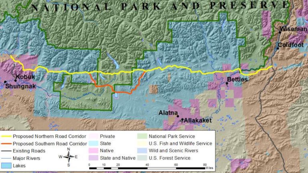
The second reason for this trip was to understand better how a proposal to build a 211-mile road from the Pipeline Haul Road (Dalton Highway) to the Ambler Mining District would impact the entire region. The proposed road’s official name is the Ambler Mining District Industrial Access Project. While most conservationists' attention is focused on keeping oil wells out of the Arctic Wildlife Refuge, the Ambler mining proposal might have a far greater reaching impact on the ecological fabric of the Brooks Range.

The Ambler Mining District is north of the river and the Inuipat villages of Kobuk, Shungnak, and Ambler. The proposed road would cut across along the southern edge of the Brooks Range, including through a portion of the Gates of the Arctic National Park and Kobuk Wild and Scenic River and native village selections and Native Corporation lands.
While I was working along the Kobuk in the 1970s, a flurry of mineral exploration occurred simultaneously. Exploratory prospecting demonstrated that this copper-lead-zinc-cobalt mineral belt extended for miles across the southern edge of the Brooks Range. By 1975, more than 10,000 mining claims covered what has become known as the Ambler Mineral Belt.
Today, the Ambler Mining Belt holds the world’s largest high-grade copper deposit. With the growing need for more copper to advance electric cars and other efforts to reduce greenhouse gas emissions, interest in developing the Ambler copper deposits has grown.
However, the high cost of mining and transportation in the Arctic has consistently thwarted the development of the Ambler copper depots. Hence, the interest in linking the Ambler district with the Pipeline Haul Road would, in theory, make the development of the minerals economically viable.

Alaska has always wanted to create a road across the southern portion of the Brooks Range as part of its long-term transportation plans. The state proposes to fund a portion of the cost of a road.
In addition, the NANA, an NW Alaska Inupiat tribal corporation, represents the people who live in northwest Alaska, including the villagers along the Kobuk River. NANA favors the development of the mine. Much of the mineralized area was selected by the natives as part of the ANCSA process, so if developed, the Kobuk villagers stand to garner not only royalties but local employment.

Among the supporters of the road are Northwest Arctic Borough, the Native Village of Shungnak, Alaska’s congressional delegation, the Alaska Chamber, the Alaska Miners Association, the Alaska Support Industry Alliance, the Council of Alaska Producers, and Resource Development Council for Alaska, Inc.
Most of the mining claims are owned by NANA corporation. In 2011, NANA and Trilogy Metals formed the Upper Kobuk Mineral Projects (UKMP). This partnership brings together Bornite and several other copper-rich prospects on NANA-owned lands with the world-class Arctic deposit and dozens of similar volcanogenic sulfide prospects on state, federal, and patented mining claims in the Ambler Mining District.
NANA wants to develop the Ambler mines as it has done for the Red Dog Mine (a zinc mine) north of Kotzebue. Red Dog is considered the most toxic mining operation in America. Profits from the Red Dog mine are a significant source of funds for NANA.
It’s important to note that if the first mines are developed, many other mineral deposits in the area will eventually follow. So this debate is about more than just this one mine and road. It will determine the future development of the entire western Brooks Range.
Local Opposition

There is opposition to the road. Some of the local villagers were ambivalent about the road. Some told me it might impact subsistence practices, but the income from jobs and royalty makes modern subsistence with snowmachines, motorboats, and ATVS possible.
On the other hand, the Tanana Chiefs Council represents the Athabascan people living along the route’s eastern portion. The villagers along this portion of the route will receive no financial benefit, but will get the impact of more people coming to hunt and fish on the lands they use for subsistence.
The Brooks Range Council has produced a video on the proposal, which you can see here.
The development of the Ambler Mining District was the reason the Alaska National Interest Lands Conservation Act (ANILCA), passed in 1980, created many national parks like the Gates of the Arctic National Park. ANILCA had a clause authorizing the road: “Congress finds that there is a need for access for surface transportation purposes across the Western (Kobuk River) unit of the Gates of the Arctic National Preserve (from the Ambler Mining District to the Alaska Pipeline Haul Road), and the Secretary shall permit such access in accordance with the provisions of this subsection.”
The Trump administration in 2020 approved the road’s construction. Fortunately, the Biden administration has remanded the decision to permit the Ambler Road back to the Bureau of Land Management for additional environmental review, giving the public another chance to halt this destructive project.
However, some observers believe this is just a delaying tactic and, ultimately, the road will be approved, especially given the Biden administration’s goal of creating more U.S. sources of critical minerals.
Ecological Impacts
The road, if built, will have numerous impacts. A tremendous amount of gravel will need to be mined to provide insulation of the permafrost, which underlies much of the proposed route.
It will cross 3,000 streams, and three caribou migration routes.
Roads can be semi-permeable barriers, and although crossing such obstacles is possible, caribou may shift or entirely abandon their seasonal habitat when confronted with a road. The disturbance and activity along the road and mining operations will likely affect caribou in other ways. Studies have shown that caribou may travel up to 9.3 miles to avoid roads and 11.2 miles to avoid settlements. For instance, a study of the Native-owned Red Dog Mine Industrial Access Road north of Kotzebue found that just four vehicles an hour affected the migration of 30 percent of collared caribou, or approximately 72,000 individuals of the 2017 population estimates.
Currently, residents can kill five caribou a day. However, the Western Arctic Caribou Herd has been in steep decline, and there is a discussion about reducing the kill. Road access may eventually result in more hunting pressure, and perhaps future reductions in caribou numbers.
Even if the Ambler Road is not built, the mine development may not go away. There are several other potential routes proposed, including one that would traverse the Kobuk Valley, where I floated, and eventually reach Nome, where ore could be shipped south for processing.
Observations
While floating the river, I stopped at all the villages along the route to gauge the changes that had occurred during the intervening 50 years since I first set foot on the banks of the Kobuk.
Most residents were friendly and helpful.

Like nearly all Alaskan native villages, the modern world is evident everywhere. The shift from subsistence food gathering to a cash economy was visible everywhere. Patagonia clothing and blue jeans have replaced fur.
The need for cash is one reason why many villagers support the development of the Ambler mines. Many villagers I spoke with periodically worked at the NANA-owned Red Dog mine to earn cash for modern conveniences. They anticipated finding employment at the Ambler mining operations if developed. Given the scarcity of employment opportunities in rural Alaska, one can sympathize with the desire to have access to high-paying mining jobs.

Everyone from elementary school children to old elders now possess cell phones. The villages all have Wi-Fi access and transportation links. Even the tiny village of Kobuk, with just 200 residents, has two flights a day from Kotzebue, the transportation hub for the region. Most homes have indoor plumbing, electricity, and fuel oil heat, though wood stoves were also evident. Some buildings even have solar panels, though I am unsure how well they work in winter when there is virtually no sunlight.

New community buildings, modern schools, and small but insulated homes dominate the villages. Most of this construction was paid for with oil money. All villages had stores where you could buy basic food supplies, though the cost was prohibitive. I recall seeing one bag of corn chips for $19.
All Terrain Vehicles (ATVs) and four-wheelers were everywhere. I didn’t see many people walking as much as I observed people just riding around for fun, making a trip to the store, or visiting neighbors. In this way, the ATVs were used like cars are by most people outside of Alaska.
Some villagers also own motorboats to run up and down the river for hunting, fishing, or just going to their camps scattered along the Kobuk.
One change I noticed since I last lived near these villages is the absence of sled dogs. When I was on the Kobuk in the 1970s, dog sleds were still a practical transportation option for running trap lines and going from village to village. With the advent of snowmachines and more regular air transportation, feeding sled dogs became an expensive liability. As one villager told me, at least when you are not using your snowmachine, you don’t have to feed it.
While running a snowmachine or ATV requires fuel, various subsidies the villagers enjoy help to keep this cost reasonable. For instance, I was told that gasoline in Kiana costs $4 a gallon, less than the price in many Western states.
Machines changed the use of the river corridor. When sled dogs were common, villagers had fish camps along the river to net salmon and other fish, fed to the dogs or for personal consumption. This is an anecdotal opinion, but it seemed to me that there were more fish camps along the river in the 1970s than I observed on my recent float. I saw many abandoned shacks and cabins that were once used as camps during the fishing season.
Some cabins were still maintained and used as a base for hunting or trapping. Some villagers liked having a cabin as a recreational getaway even though the villages were surrounded by miles of wildlands.
Least-Visited National Park
During the entire float, we saw no other recreationalists on the river. Every other day, we might see some natives driving a boat up or down the stream, but we did not see anyone else floating or camping along the river corridor.

Indeed, when we stopped on river bars to stretch our legs or camp for the night, we never saw any other human footprints, though we saw plenty of grizzly, wolf, and moose tracks.
Even with the occasional boat passing by and a few cabins along the river, the overall impression one has of the Kobuk Valley National Park is of its remoteness and wildness. And if my impression about the decline in fish camps and other native use of the river is accurate, it may even be wilder today than in the 1970s.
In keeping with its reputation as the least-visited national park, there was no “Welcome to your National Park” sign. There were no ranger stations. There were no rangers. There were no trails. No interpretative signs.
Even one of the significant geological features of the park, the Kobuk Valley dunes, was inaccessible. We searched for a trail that would take us to the dunes but could not locate one, if it existed.
In Conclusion
I recognize that if I were a villager living along the Kobuk River, I might support the proposed road. Although it is being called a private industrial road closed to public use, the same was said of the Dalton Highway. If opened to public use, the road would likely make it far less expensive for villagers to obtain everything from lumber to fuel oil to food.
In a region where job opportunities are notoriously seasonal and limited, employment at a mine would provide valuable income to villagers.
Nevertheless, the development of the Ambler Mining District will bring irreversible cultural and ecological changes to the Kobuk River valley. I met a man in Ambler who had just returned from a hunting trip. He had moved to Ambler to pursue a subsistence lifestyle.
Not everyone, even villagers living along the river, would choose to return to a fully subsistence lifestyle. But where else can one even have such a choice?
For those who have grown up along the Kobuk, the decision to continue such a subsistence lifestyle is still available. While enjoying many of the modern amenities available everywhere, many native people choose to hunt and fish to supplement their cash economy. The full development of the Ambler Mining District, may preclude this choice.
And where else can you go and see far more grizzly and wolf tracks than human footprints? Remote and wild places are increasingly scarce. The Brooks Range’s most outstanding value is its wildlands.

The question for me and others who oppose the Ambler mine development is whether the benefits of industrialization of one of the wildest places in Alaska are worth the cost. While the Ambler mineral zone does possess globally significant ore resources, these minerals can be obtained elsewhere, where the ecological and social costs are lower.
Are we wise enough to recognize that wilderness and wildness has intrinsic value, and that preservation of these attributes is worth more than copper and other minerals?
The answer to my question may be determined soon, depending on the outcome of the BLM and Biden administration decisions.
George Wuerthner has worked as Ecological Projects director for the Foundation for Deep Ecology and Tompkins Conservation. He also was a visiting lecturer on Alaskan Environmental Politics at the University of California, Santa Cruz, and taught various field ecology classes for San Francisco State University, University of California Santa Barbara, Prescott College, and environmental writing at the University of Vermont. He was a ranger at the Gates of the Arctic National Park and river ranger on the Fortymile Wild and Scenic River, both in Alaska, and a botanist for the BLM.
Story Categories:
A copy of National Parks Traveler's financial statements may be obtained by sending a stamped, self-addressed envelope to: National Parks Traveler, P.O. Box 980452, Park City, Utah 84098. National Parks Traveler was formed in the state of Utah for the purpose of informing and educating about national parks and protected areas.
Residents of the following states may obtain a copy of our financial and additional information as stated below:
- Florida: A COPY OF THE OFFICIAL REGISTRATION AND FINANCIAL INFORMATION FOR NATIONAL PARKS TRAVELER, (REGISTRATION NO. CH 51659), MAY BE OBTAINED FROM THE DIVISION OF CONSUMER SERVICES BY CALLING 800-435-7352 OR VISITING THEIR WEBSITE. REGISTRATION DOES NOT IMPLY ENDORSEMENT, APPROVAL, OR RECOMMENDATION BY THE STATE.
- Georgia: A full and fair description of the programs and financial statement summary of National Parks Traveler is available upon request at the office and phone number indicated above.
- Maryland: Documents and information submitted under the Maryland Solicitations Act are also available, for the cost of postage and copies, from the Secretary of State, State House, Annapolis, MD 21401 (410-974-5534).
- North Carolina: Financial information about this organization and a copy of its license are available from the State Solicitation Licensing Branch at 888-830-4989 or 919-807-2214. The license is not an endorsement by the State.
- Pennsylvania: The official registration and financial information of National Parks Traveler may be obtained from the Pennsylvania Department of State by calling 800-732-0999. Registration does not imply endorsement.
- Virginia: Financial statements are available from the Virginia Department of Agriculture and Consumer Services, 102 Governor Street, Richmond, Virginia 23219.
- Washington: National Parks Traveler is registered with Washington State’s Charities Program as required by law and additional information is available by calling 800-332-4483 or visiting www.sos.wa.gov/charities, or on file at Charities Division, Office of the Secretary of State, State of Washington, Olympia, WA 98504.

National parks and their natural resources belong to you. The National Parks Traveler works to ensure you know how these essential places are being cared for.
Sign Up For Our Weekly Newsletter
Unsubscribe at any time.
INN Member

The easiest way to explore RV-friendly National Park campgrounds.

Here’s the definitive guide to National Park System campgrounds where RVers can park their rigs.
Our app is packed with RVing- specific details on more than 250 campgrounds in more than 70 national parks.
You’ll also find stories about RVing in the parks, tips helpful if you’ve just recently become an RVer, and useful planning suggestions.

Comments
Interesting read. Enjoyed the video. Thanks
I've talked to the Red Dog miners, and it is one of the cleanest mines anywhere. Fish now live in the nearby streams that previously did not. The owners, operators and workers are Inuit who have an unquestionable love of the land and will not sacrifice it for economic gain when it is NOT necessary to do so. And if we've learned anything from the Dalton Highway, it is that the Caribou love it and have increased in numbers, perhaps because of it. Yes, mining should be done with strict overwatch of environmental problems. If the Kobuk River did not freeze over in the winter, I would suggest THAT as the preferred route for taking out the minerals, but the Ambler Road would have a similar problem. Oh, and as for the "Biden administration’s goal of creating more U.S. sources of critical minerals," that is laughable, since they are doing everything to PREVENT such with their environmental policies.
Watch the video.
The realistic conclusion is that this is a question of when, not if.
George - The individual native allotments are obtained via the language of the 1906 Alaska Native Alottment Act, as amended, not from ANILCA, so most existed prior to 1980.
George and Snochasr and, I guess Kurt too:
some observations
George has some truth to his view that the Ambler Industrial Mining Road was a condition of passage Of Jimmy Carter's law creating so many parks, wildlife refuges, National Forest WildErnest's, and National Wild Rivers
(Oh, and George, PS: the Kobuk is NOT a "Wild and Scenic River." It is a National WILD River. There are rivers in the lower 48 that have more than one designation - there even is a river in one segment "wild" another "scenic," and another segment "recreation" River. The designation depends free flowing criteria, and every one of the rivers in the National Wild and Scenic Rivers System is "Wild." Just like you would not call the same park system unit a "national park" and "national monument," same with national rivers.)
But George overstates the idea that the road is inevitable. First of all, when Congress made the exception for the industrial mining road right-of-way, they did not recognize it would be a big deal. Later information shows it is the greatest impairment to FOUR NPSystem areas, probably the greatest impairment in the history of the System of parks. The only point Congress mentioned it was stretching was crossing the Kobuk National Wild River: normally no bridges can cross a Wild river. But the idea that the road and mine and mine would devastate the primary park and wildlife refuge resources of 4 parks and 1 refuge, this they did not know.
The advocates did not even admit to Congress that no one in the development corporation or mining company has actually walked the route! Or, more importantly, that the road wiud have to cross nearly 3,000 rivers and streams !! The constant grading on the fisheries of these streams, on top of the slowly melting "permafrost" transition thanks to global warming, would make the bridges, roads and fords a constant environmental hazzard. And advocates never came clean, what they really were asking for.
this is big, because in the history of park, many were given special exceptions, but when exceptions turned out to be big park impairment, Congress ACTED to fix the problem.
the other missing piece, Trump did not follow the total rules, not just the micro-part of the statute George quotes.
Congress requires that the transportation application includes all the special requirements of the transportation corridors, but the special character of the Ambler needs are not included.
And, NPS negotiators demanded that the thorough review of impacts on subsistence food and way of life be clean. The Trump subsistence review is a joke. Even less of a joke, the section 106 cultural impacts are barely addresses at all: Trump's study just said, 'catch you later,' after the road is approve.
as to Snochasr, his bias is showing. There is nothing comparable between the Red Dog Mine, and the gigantic Ambler nightmare. Ambler crosses the rivers and the caribou migration routes with a caravan of trucks, but Red Dog follows the ridge and avoids caribou habitat plus of course, state and federal inspectors found many examples of pollutio.
Finally, to our friend Kurt:
how could you ever exclude the history this year over the colossal fight to through out the Trump road approvals in your review of the big stories of 2024?
For the project that promises the most damage to national park system resources in the NPS history - or certainly Building dams at Yosemite -- your grandchildren would not be pleased at missing the story bigger than any of those you did review
if you were not such a good guy, I would call this unforgivable.