
Editor's note: Volcano Watch is a weekly article and activity update written by U.S. Geological Survey Hawaiian Volcano Observatory scientists and affiliates.
Five years ago, volcanic activity at Kīlauea dramatically changed when magma intruded into the lower East Rift Zone (LERZ). What happened at Kīlauea in 2018? What have been the resulting learning opportunities?
The events in 2018 ended the 35-year-long Pu‘u‘ō‘ō eruption (on the middle East Rift Zone), along with the 10-year summit eruption—the summit lava lake drained, as did some of the shallow magma stored beneath the summit, which in turn triggered collapse and subsidence of the summit caldera floor.
The sequence of events began on April 30, 2018, when Pu‘u‘ō‘ō crater floor collapsed as magma began intruding downrift. Over the next several days seismic and deformation data tracked the dike as it migrated underground farther down the East Rift Zone.
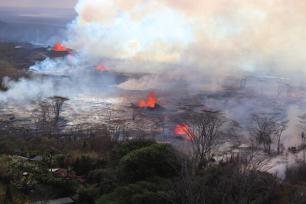
The first LERZ eruption in 58 years began on the evening of May 3 when a fissure opened in Leilani Estates Subdivision. By the end of May 4, six fissures had opened in the LERZ and a magnitude-6.9 earthquake struck the south coast of the Island of Hawai‘i.
The summit lava lake level began to drop as magma moved into the LERZ, and sections of the unsupported crater walls fell into the lake, triggering small explosive events. Hawai‘i Volcanoes National Park closed to the public on May 11, and Hawaiian Volcano Observatory (HVO) staff vacated the office on Uēkahuna bluff on May 16 due to increased ash explosions, seismic activity, and building damage.
From early-May to late-August, HVO staff, with help from the USGS Volcano Science Center, the University of Hawai‘i, and other Department of the Interior offices, maintained a 24-hour field presence and data watch to monitor the eruption and communicate any changes to the public and emergency managers. These collaborations were essential for continuous monitoring and data analysis, but they also introduced new monitoring techniques like using Unoccupied Aircraft Systems (UAS). UAS flights are now included as part of HVO’s routine eruption monitoring tasks.
The 2018 eruption was the most destructive over the last 200 years in Hawai‘i, with 24 fissures covering an area of over 8,700 acres (35.5 square km) including the addition of 875 acres of new land beyond the old coastline. Over 700 structures and 30 miles (48 km) of roads were covered, displacing many residents. Gas emissions were at the highest levels ever recorded at Kīlauea and impacted much of the State of Hawaii and areas as far away as Guam.
The summit region experienced 62 total collapse events during the eruption. These near-daily occurrences each released energy roughly equivalent to a magnitude-5.3 earthquake. Shaking from these events caused damage to nearby homes and businesses, along with Hawai‘i Volcanoes National Park roads and infrastructure and the former HVO building. Volcanic ashfall from explosions in May, and gas emissions, also impacted downwind communities in the District of Ka‘ū.
Recovery efforts are still underway for Island of Hawai‘i communities impacted by the 2018 eruption, and for HVO.
Some of HVO’s new monitoring capabilities include cutting edge field equipment for tracking seismicity, ground deformation, gas, gravity, lava lake level, and surface changes. Lab equipment that can analyze physical and chemical characteristics of ash and cinder and lava samples, providing insights on eruptive processes, has also been acquired thanks to the Supplemental funding.
Exciting new research has also been taking place at Kīlauea to help improve our understanding of the volcano’s magma plumbing system and structure, eruptive past, and hazards. This includes the ongoing Kīlauea Seismic Imaging Project.
In the years since 2018, HVO has had the opportunity to apply lessons learned during 2018 to several Kīlauea summit eruptions and the first Mauna Loa eruption in 38 years. Research and monitoring upgrades funded through the Supplemental Funding have advanced our understanding of Hawaiian volcanoes, helping us to learn more about their hazards and potential future eruption impacts.
Volcano Activity Updates
Kīlauea is not erupting. Its USGS Volcano Alert level is ADVISORY.
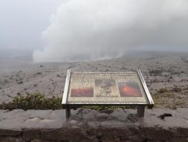
Webcams show no signs of active lava in Halemaʻumaʻu crater, at the summit of Kīlauea in Hawai‘i Volcanoes National Park. Over the past week, summit tiltmeters showed inflation and seismicity has been variable. The summit sulfur dioxide (SO2) emission rate was most recently measured on May 3, when it totaled 135 tonnes per day.
Mauna Loa is not erupting. Its USGS Volcano Alert Level is at NORMAL.
Webcams show no signs of activity on Mauna Loa. Seismicity remains low. Summit ground deformation rates show inflation above background levels, but this is not uncommon following eruptions. SO2 emission rates are at background levels.
There were two earthquakes with 3 or more felt reports in the Hawaiian Islands during the past week: a M3.0 earthquake 4 km (2 mi) SSE of Pāhala at 31 km (19 mi) depth on April 29 at 6:34 p.m. HST and a M0.5 earthquake 4 km (2 mi) SW of Volcano at 1 km (0 mi) depth on April 27 at 7:59 a.m. HST.
HVO continues to closely monitor Kīlauea and Mauna Loa.
Please visit HVO’s website for past Volcano Watch articles, Kīlauea and Mauna Loa updates, volcano photos, maps, recent earthquake information, and more. Email questions to [email protected].
Stories about:
Story Categories:
A copy of National Parks Traveler's financial statements may be obtained by sending a stamped, self-addressed envelope to: National Parks Traveler, P.O. Box 980452, Park City, Utah 84098. National Parks Traveler was formed in the state of Utah for the purpose of informing and educating about national parks and protected areas.
Residents of the following states may obtain a copy of our financial and additional information as stated below:
- Florida: A COPY OF THE OFFICIAL REGISTRATION AND FINANCIAL INFORMATION FOR NATIONAL PARKS TRAVELER, (REGISTRATION NO. CH 51659), MAY BE OBTAINED FROM THE DIVISION OF CONSUMER SERVICES BY CALLING 800-435-7352 OR VISITING THEIR WEBSITE. REGISTRATION DOES NOT IMPLY ENDORSEMENT, APPROVAL, OR RECOMMENDATION BY THE STATE.
- Georgia: A full and fair description of the programs and financial statement summary of National Parks Traveler is available upon request at the office and phone number indicated above.
- Maryland: Documents and information submitted under the Maryland Solicitations Act are also available, for the cost of postage and copies, from the Secretary of State, State House, Annapolis, MD 21401 (410-974-5534).
- North Carolina: Financial information about this organization and a copy of its license are available from the State Solicitation Licensing Branch at 888-830-4989 or 919-807-2214. The license is not an endorsement by the State.
- Pennsylvania: The official registration and financial information of National Parks Traveler may be obtained from the Pennsylvania Department of State by calling 800-732-0999. Registration does not imply endorsement.
- Virginia: Financial statements are available from the Virginia Department of Agriculture and Consumer Services, 102 Governor Street, Richmond, Virginia 23219.
- Washington: National Parks Traveler is registered with Washington State’s Charities Program as required by law and additional information is available by calling 800-332-4483 or visiting www.sos.wa.gov/charities, or on file at Charities Division, Office of the Secretary of State, State of Washington, Olympia, WA 98504.

National parks and their natural resources belong to you. The National Parks Traveler works to ensure you know how these essential places are being cared for.
Sign Up For Our Weekly Newsletter
Unsubscribe at any time.
INN Member

The easiest way to explore RV-friendly National Park campgrounds.

Here’s the definitive guide to National Park System campgrounds where RVers can park their rigs.
Our app is packed with RVing- specific details on more than 250 campgrounds in more than 70 national parks.
You’ll also find stories about RVing in the parks, tips helpful if you’ve just recently become an RVer, and useful planning suggestions.
