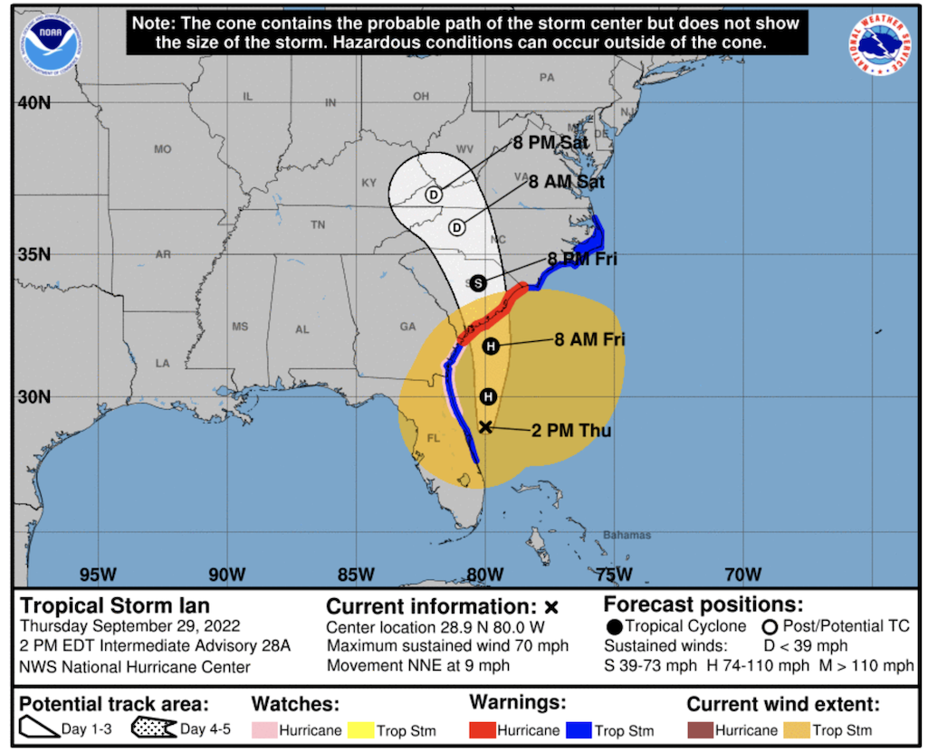
National parks in the path of Hurricane Ian were altering their operations for the weekend/NOAA
Editor's note: This updates with closure information from the Blue Ridge Parkway.
With Hurricane Ian expected to come ashore Friday in Georgia and South Carolina as a tropical storm and continue on up the coast, National Park System units are instituting closures or urging visitors to be mindful of the storm.
In South Carolina, Congaree National Park was closing Thursday afternoon to prepare for the storm.
Current plans are to reopen the park, pending assessments of roads and facilities, on Sunday morning. Until then, at least, all park facilities, campgrounds, hiking and paddling trails will be closed to the public. Events and programs scheduled for this weekend’s SwampFest event at the Harriet Barber House and Congaree National Park have been canceled and rescheduled for Saturday, October 22.
As of the 8 a.m. local time Thursday, Tropical Storm Ian was forecast to regain strength once it has moved offshore of Florida, reaching maximum sustained winds of 70 mph prior to making landfall in South Carolina on Friday evening. Starting Friday evening, the area around Congaree National Park is likely to see tropical storm strength winds and up to six inches of rain. During periods of high winds and heavy rain there is an increased risk of trees falling and flash flooding within the park and on area roads.
At the Blue Ridge Parkway in North Carolina and Virginia, the National Park Service says it is preparing for a range of potential impacts across the southern end of the parkway. This weekend, visitors should expect closures and use caution due to expected periods of heavy rainfall, flooding, and strong wind.
Based on the projected course of the storm, closures will start in the following locations beginning late afternoon on Friday:
- Milepost 318 - 375.2 from Linville Spur Road to Bull Gap
- Milepost 393 - 406 from the French Broad overlook to Rte 151 entrance (north side)
- MP 412.9 - 443 from Hwy 276 (south side) to Balsam Gap
- MP 446 - 469 from Balsam Gap to southern terminus.
These severe weather closures are full closures to all public use. Closures are expected to remain in place through at least mid-day Sunday and will re-open once assessments have been made, any storm damage cleared, and the park is deemed safe for visitation.
As a result, the following facility impacts are also expected through at least mid-day on Sunday or longer depending on the extent of needed cleanup efforts.
- Pisgah Inn will remain accessible via both Hwy 151 and Hwy 27, providing two egress routes in opposite directions for visitors.
- Craggy Gardens Visitor Center at milepost 364 and Waterrock Knob Visitor Center at milepost 451.2 will be closed.
Where conditions permit and the road remains open, park visitors are reminded to use extreme caution and be aware of the potential for falling rocks and downed trees. As always, the parkway requires driving with extra care due to its narrow road shoulders, steep grades, and numerous curves. Park visitors must use caution, adhere to posted speed limits and be prepared to stop or turn around at closed gates or road debris during this storm event.
Updates and information regarding the status of park facilities, including the road itself, will be available on parkway’s website, and its Twitter and Facebook pages. Park visitors and neighbors are encouraged to check these sites regularly for information and before heading out to the Parkway.
In North Carolina, visitors to Cape Hatteras National Seashore, Fort Raleigh National Historic Site, and Wright Brothers National Memorial were urged to use caution due to expected periods of heavy rainfall, flooding, and strong wind.
Cape Hatteras National Seashore
Swimming
Visitors should avoid swimming in the ocean due to high surf and dangerous rip currents. Sign up for beach-related weather and ocean condition alerts by texting OBXBeachConditions to 77295. Learn how to stay safe at the beach at www.lovethebeachrespecttheocean.com.
Rodanthe Beach
Visitors should avoid a two-mile stretch of beach, between the north end of Rodanthe and South Shore Drive, due to the presence of several vulnerable houses that may be damaged by rough surf and strong winds. The area should be avoided through this weekend.
Road, Ferry and Beach Travel
Travel on portions of N.C. Highway 12, especially near the north ends of Hatteras and Ocracoke islands, may be difficult late this evening through tomorrow. Monitor road conditions at https://drivenc.gov.
Ferry services to and from Ocracoke Island may be suspended. Call 252-996-6000 or 6001 for current information.
Many off-road vehicle routes may become impassable. Visit https://go.nps.gov/beachaccess for beach access updates.
Bodie Island Lighthouse Climbing and Educational Programs
Bodie Island Lighthouse climbing is closed Sept. 30-Oct. 1. Regular climbing opportunities will be available at the Bodie Island Lighthouse from Wednesday, Oct. 5 through the end of the climbing season Saturday, Oct. 8.
All educational programs at Cape Hatteras National Seashore are canceled Sept. 30-Oct. 1.
Camping
Campgrounds are open but camping conditions are not expected to be favorable over the next several days. Visitors with reservations have been notified of the inclement weather. If the weather forecast worsens, one or more campgrounds may need to be closed until conditions improve.
Fort Raleigh National Historic Site
Visitors should avoid walking through the park’s trails during strong winds due to the potential for tree and tree branch collapses. All educational programs are canceled Sept. 30-Oct. 1.
Wright Brothers National Memorial
All educational programs are canceled Sept. 30-Oct. 1.
Information on storm impacts at Dry Tortugas National Park and other units impacted by Hurricane Ian have not yet been available from the Park Service.


Add comment