Rocky Mountain National Park, with its sky-scraping peaks, deep valleys gouged from the landscape once-upon-a-time by glaciers and now cut further by creeks and rivers fueled by snowmelt, and forests thick with spruce and fir and pine, all dappled with aspens, is a hiker's dreamscape. Though there are only 355 miles of marked trails, far fewer than Great Smoky Mountains, Yellowstone, Glacier, and many other national parks, Rocky Mountain "hikes" much bigger than it seems.
Maybe that's because many of the trails are in the shadow of mountains, or because you spend so much time stopping to take in the landscape, the lakes and streams, the forests.
There are many trailheads in Rocky Mountain, and so choosing a hike is not always easy, unless you're being led down a path by one who has been there many times before. The Bear Lake Road is a popular starting point, as many trailheads pivot from it. There's Bierstadt, Sprague Lake, Storm Pass, Glacier Gorge, trails leaving the Glacier Basin Campground and, of course, Bear Lake with its trailheads.
On a spectacular fall day in mid-October I chose the Glacier Gorge Trailhead, in part because I had previously used Bear Lake for a starting point and was familiar with its offerings, and Glacier Gorge is dotted with sublime lakes. One needs to get to the trailhead early if they want to snag a parking spot, and as I pulled into the parking area at 8:30 a.m. on a Friday even that was barely early enough, as there was only one or two spots left.
(Traveler note: The Bear Lake area is extremely popular, and unless you're able to get out early in the morning, it's wise to opt for a shuttle bus ride there. If you don't, during the busy summer season and gorgeous fall you could be stopped at Moraine Park by a ranger and told you'll either have to wait for some traffic to leave Bear Lake or head to some other spot in the park.)
After a quick stop at the restroom, I headed up the trail, one that started out wide with well-spaced logs to help hold things in place from the foot, and hoof, traffic that follows it into the high country. The route to Mills Lake runs 2.8 miles, according to park statistics, and rises a reasonable 750 feet in elevation, to 9,940 feet.

Along the way there are many trails that split off to entice you in different directions. You could abandon Mills Lake and take a shorter hike to Bear Lake itself, or stop at Alberta Falls less than a mile on the trail to Mills Lake. Or you could head over to Sprague Lake or into Glacier Basin.
There are other paths that will lead you to Loch Vale, Sky Pond, Andrews Glacier, and Lake Haiyaha, to Boulder Brook, Granite Pas, and the Boulder Field.
Tempting as many of them were for a day hike, I had settled on Mills Lake because of the way it's nestled at the bottom of Glacier Gorge, far below and between Thatchtop (12,668 feet) and Half Mountain (11,482).
And I wanted to visit the lake because it was named for Enos Mills, the accepted "Father of Rocky Mountain National Park." It's a tidbit of cultural history of Rocky Mountain National Park, one that likely is lost on most hikers who trek to this slender body of water. But also one that is worth a little time investigating, as this once-sickly boy found recuperation and a molding of character in these rocky mountains. Inspired and enouraged by John Muir, Enos Mills waged a campaign to see these mountains in Colorado protected as a national park, a deed won in 1915.
He was as determined as Muir to see some of America's most scenic vistas set aside as national parks, stating at one point that, "It is important that the remaining scenic areas of the country be at once made into State or National Parks. Fortunately there still are a number of these wild places, but it will require effort to save them. Each Park proposed will have powerful and insidious opposition. The insidious opposition to National Parks will say, ‘There is a feeling in Congress that we should not have any more National Parks at this time’; or, ‘We should wait until present ones are improved.’"
Moving on, the trail took me across both Glacier and Chaos creeks, offered a spot to pause and admire Alberta Falls, and slowly coursed higher and higher into the backcountry. The sturdy condition of the trail early on is a credit to both the National Park Service and the Rocky Mountain Conservancy, which collaborated on a trail rehabilitation completed five years ago.
At one point, a bit beyond the junction with the Loch Vale Trail, the Mills Lake Trail passes into Glacier Gorge itself through a relative pinch point of the north ends of Thatchtop and Half Mountain that, on the day I passed by, created a veritable wind tunnel as gusts dropped out of the high country and roared between these mountains.
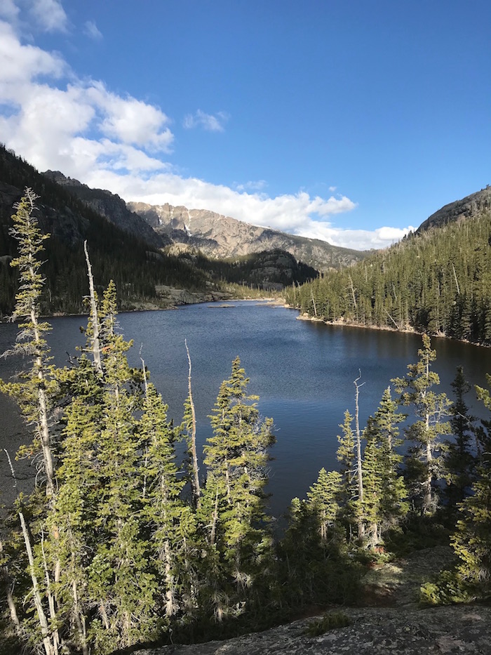
Not too much further I came upon Mills Lake. Slabs of granite jutted out from the shoreline, making wonderful perches to contemplate the scenery or relax with a picnic. Stellar Jays came fluttering in, looking for a handout, nervously craning their heads about before flitting off, disappointed.
The cool weather, bright sun, and pre-noon hour convinced me to push past Mills Lake to Black Lake, a little more than two miles farther into the park's interior. For those seeking an easy overnight, this is a great option, as the trail leads to a short spur that crosses Glacier Creek and leads to the Glacier Gorge backcountry campite set at 10,000 feet.
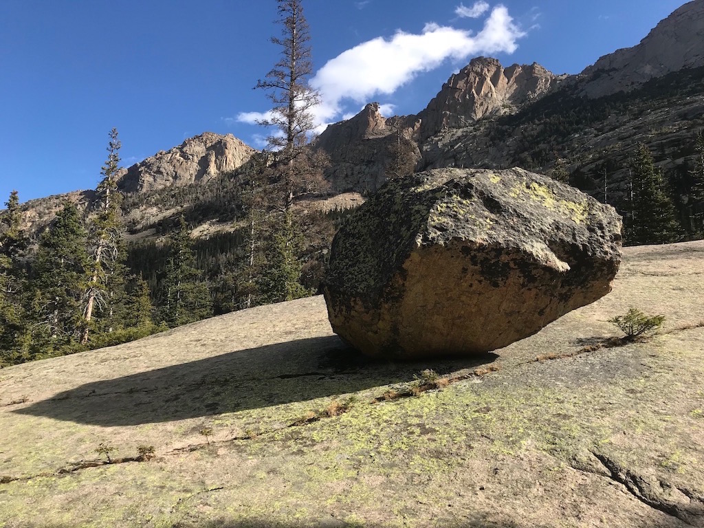
Passing by diminutive Jewel Lake I soon came to one of the best geologic displays to be had, a glacial erractic perched atop a massive slab of rock. How long has it been there? How long might it be before it's gone? The most recent glaciation across North America was the Wisconsin (also known as the Pinedale glaciation in the Rockies), which lasted from 70,000 to 10,000 years ago.
I soon caught up to another couple with the same goal in mind, and we shared the trail and chatted about parks, political forces, and the incredible landscape we were crossing. Comradship is one of the not-to-be ignored beauties of hiking. The strangers you meet already share at least one aspect of life with you: nature. And discussion takes your mind off the miles you're treading.
We soon knew Black Lake was nearby when we came upon Ribbon Falls, a relatively sedate curtain of water sliding out of the lake and down a rock slide at this time of year. When spring melt is in full fury, the falls fumes with runoff. Early snows already had buried portions of the trail from this point on, and we carefully jammed our boots into the snow for sound footing; the points of our hiking sticks contributed to our safety by anchoring themselves in the hard-packed snow.
Black Lake shares much in landscape with Avalanche Lake in Glacier National Park. Both are cradled by a rising rocky cauldron on three sides, a cauldron decorated with slender rivers of ice and icicles dangling from cliffsides.
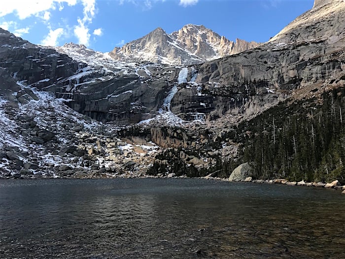
It was a sublime setting at roughly 11,000 feet. The lake shimmering beneath a cerulean sky carrying billowing clouds whipped by on the winds. On the west side rises The Arrowhead, a 12,387-foot craggy point of rock extending north from McHenrys Peak, while to the south and higher yet is 13,579-foot Chiefs Head Peak. Intrepid hikers can push on a bit further from Black Lake by following faint trails to Green Lake and Frozen Lake.
The return to the trailhead would traverse 5 miles, but it would be a well-rewarding passage.
"The trail compels you to know yourself and to be yourself, and puts you in harmony with the universe," Enos Mills once said. "It makes you glad to be living. It gives health, hope, and courage, and it extends that touch of nature which tends to make you kind."
Stories about:
Story Categories:
A copy of National Parks Traveler's financial statements may be obtained by sending a stamped, self-addressed envelope to: National Parks Traveler, P.O. Box 980452, Park City, Utah 84098. National Parks Traveler was formed in the state of Utah for the purpose of informing and educating about national parks and protected areas.
Residents of the following states may obtain a copy of our financial and additional information as stated below:
- Florida: A COPY OF THE OFFICIAL REGISTRATION AND FINANCIAL INFORMATION FOR NATIONAL PARKS TRAVELER, (REGISTRATION NO. CH 51659), MAY BE OBTAINED FROM THE DIVISION OF CONSUMER SERVICES BY CALLING 800-435-7352 OR VISITING THEIR WEBSITE. REGISTRATION DOES NOT IMPLY ENDORSEMENT, APPROVAL, OR RECOMMENDATION BY THE STATE.
- Georgia: A full and fair description of the programs and financial statement summary of National Parks Traveler is available upon request at the office and phone number indicated above.
- Maryland: Documents and information submitted under the Maryland Solicitations Act are also available, for the cost of postage and copies, from the Secretary of State, State House, Annapolis, MD 21401 (410-974-5534).
- North Carolina: Financial information about this organization and a copy of its license are available from the State Solicitation Licensing Branch at 888-830-4989 or 919-807-2214. The license is not an endorsement by the State.
- Pennsylvania: The official registration and financial information of National Parks Traveler may be obtained from the Pennsylvania Department of State by calling 800-732-0999. Registration does not imply endorsement.
- Virginia: Financial statements are available from the Virginia Department of Agriculture and Consumer Services, 102 Governor Street, Richmond, Virginia 23219.
- Washington: National Parks Traveler is registered with Washington State’s Charities Program as required by law and additional information is available by calling 800-332-4483 or visiting www.sos.wa.gov/charities, or on file at Charities Division, Office of the Secretary of State, State of Washington, Olympia, WA 98504.

National parks and their natural resources belong to you. The National Parks Traveler works to ensure you know how these essential places are being cared for.
Sign Up For Our Weekly Newsletter
Unsubscribe at any time.
INN Member

The easiest way to explore RV-friendly National Park campgrounds.

Here’s the definitive guide to National Park System campgrounds where RVers can park their rigs.
Our app is packed with RVing- specific details on more than 250 campgrounds in more than 70 national parks.
You’ll also find stories about RVing in the parks, tips helpful if you’ve just recently become an RVer, and useful planning suggestions.

Comments
Beautiful area.
One of my favorite areas in all of Rocky Mountain National Park. The scenary never gets boring all the way to Black Lake and beyond, it's out of this world. Nice write up :)