A wildfire burning on the west side of Big Cypress National Preserve in Florida covered more than 6,000 acres Tuesday and forced additional closures in the park.
Smoke from the fire was initially spotted Saturday evening, when the blaze was estimated to cover about 60 acres. Located north of the Burns Lake Campground, the fire continued to spread, reaching more than 3,000 acres on Sunday, and 6,020 on Monday afternoon.
Nicknamed the "Parliament Fire," the blaze is burning in a mixture of grass, pine, and cypress habitat. The Southwest Florida and Caribbean Fire and Aviation Management Program, a cooperative program between Big Cypress National Preserve and the U.S. Fish and Wildlife Service Region 4, District 6, had sent aviation and ground resources to the fire line. Due to the remote location and limited access, a Type 3 incident command organization was being mobilized to manage the fire.
“Current containment strategies, including natural and human-made barriers, as well as trail and area closures, have been implemented to protect firefighters and the public,” said Big Cypress Superintendent Tamara Whittington.
Visitors and commuters should expect smoke along U.S. Highway 41, Burns Lake Road, and Monument Lake Campground due to extensive smoke from the fire. The Florida Department of Transportation has issued a road closure for U.S. 41 from State Road 29 to Chrome Avenue beginning at 2:30 p.m. Tuesday as conditions permit.
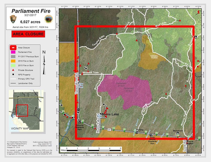
Closures related to the fire include:
- Burns Lake Campground, day use area, and Burns Lake Road
- Lands to the east of Turner River Road, south of Concho Billie Trail, west of Monument Lake Trail, extending north of Tamiami Trail, U.S. Highway 41
- Skillet Strand Trail and parking area
- Windmill Tram Trail
- Burns Lake Trail north to Concho Billie Trail, and Burns Lake Trail South to Tamaimi Trail, U.S. 41
Stories about:
Story Categories:
A copy of National Parks Traveler's financial statements may be obtained by sending a stamped, self-addressed envelope to: National Parks Traveler, P.O. Box 980452, Park City, Utah 84098. National Parks Traveler was formed in the state of Utah for the purpose of informing and educating about national parks and protected areas.
Residents of the following states may obtain a copy of our financial and additional information as stated below:
- Florida: A COPY OF THE OFFICIAL REGISTRATION AND FINANCIAL INFORMATION FOR NATIONAL PARKS TRAVELER, (REGISTRATION NO. CH 51659), MAY BE OBTAINED FROM THE DIVISION OF CONSUMER SERVICES BY CALLING 800-435-7352 OR VISITING THEIR WEBSITE. REGISTRATION DOES NOT IMPLY ENDORSEMENT, APPROVAL, OR RECOMMENDATION BY THE STATE.
- Georgia: A full and fair description of the programs and financial statement summary of National Parks Traveler is available upon request at the office and phone number indicated above.
- Maryland: Documents and information submitted under the Maryland Solicitations Act are also available, for the cost of postage and copies, from the Secretary of State, State House, Annapolis, MD 21401 (410-974-5534).
- North Carolina: Financial information about this organization and a copy of its license are available from the State Solicitation Licensing Branch at 888-830-4989 or 919-807-2214. The license is not an endorsement by the State.
- Pennsylvania: The official registration and financial information of National Parks Traveler may be obtained from the Pennsylvania Department of State by calling 800-732-0999. Registration does not imply endorsement.
- Virginia: Financial statements are available from the Virginia Department of Agriculture and Consumer Services, 102 Governor Street, Richmond, Virginia 23219.
- Washington: National Parks Traveler is registered with Washington State’s Charities Program as required by law and additional information is available by calling 800-332-4483 or visiting www.sos.wa.gov/charities, or on file at Charities Division, Office of the Secretary of State, State of Washington, Olympia, WA 98504.

National parks and their natural resources belong to you. The National Parks Traveler works to ensure you know how these essential places are being cared for.
Sign Up For Our Weekly Newsletter
Unsubscribe at any time.
INN Member

The easiest way to explore RV-friendly National Park campgrounds.

Here’s the definitive guide to National Park System campgrounds where RVers can park their rigs.
Our app is packed with RVing- specific details on more than 250 campgrounds in more than 70 national parks.
You’ll also find stories about RVing in the parks, tips helpful if you’ve just recently become an RVer, and useful planning suggestions.
