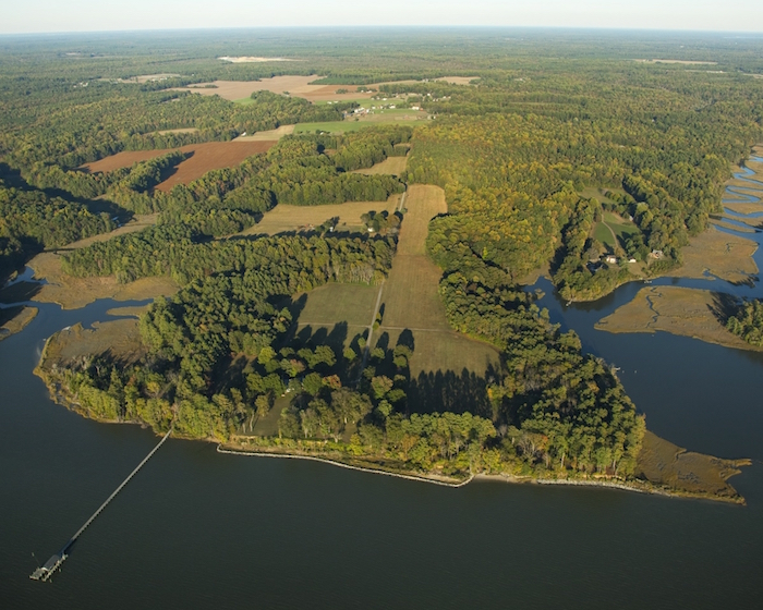
A promontory jutting into the York River in Virginia that was the center of the Powhatan Chiefdom when Captain John Smith reached the new world in 1607 has been added to the Captain John Smith Chesapeake National Historic Trail to help tell a key story in the history of America.
The 264-acre property, known as Werowocomoco, was the location of where Captain Smith met Pocahontas following his capture, according to an Interior Department release.
U.S. Secretary of the Interior Sally Jewell last week joined Virginia Gov. Terry McAuliffe and the chiefs of five American Indian tribes to recognize the acquisition of Werowocomoco, a major American Indian site of international significance in Virginia.
With the support of landowners, the Commonwealth of Virginia, Virginia Indian Tribes, and several non-profit organizations, the National Park Service was able to obtain $7.1 million in federal Land and Water Conservation Fund funding to purchase the land from Bob and Lynn Ripley. The deal was finalized in June, though Interior officials just announced it this past week.
“The addition of Werowocomoco to the National Park Service will help tell an important part of our nation’s history,” Secretary Jewell said in a release. “As one of the most important American Indian sites in the eastern United States, the protection, study and interpretation of Werowocomoco, in conjunction with tribes in the region, will bring this important story of the nation’s indigenous people to life in the National Park Service’s second century.”
Werowocomoco will be managed by the Park Service through its Chesapeake office and their staff on the Captain John Smith Chesapeake National Historic Trail. It is not yet open to the public. Trail staff will begin a public planning process this winter in close consultation with the Virginia tribes.
“As a Virginian with an ancestor who landed at Jamestown in 1620, the acquisition of this important space is very personal to me,” Park Service Director Jonathan Jarvis said in a release. “To many Americans, Werowocomoco represents the intersection between two dynamic cultures. But to many Virginians, it is significant for the less-told story – the story of people who were here long before John Smith or my ancestors, and whose descendants are an important part of our America.”
Werowocomoco is a rarity in Virginia archaeological finds – an intact, relatively undisturbed, town site and cultural landscape. Archaeology indicates it had been a major town for several centuries before Powhatan, according to the Interior Department
"I am very pleased that we and many partners, particularly the Tribes, the Ripleys, The Conservation Fund, Chesapeake Conservancy, Commonwealth and Gloucester County, were able to work together to save this very important place," said Chuck Hunt, superintendent of the national historic trail. "While the site is not yet open to the public, we look forward to working with the Virginia Tribes and our other partners to share this important place and story with the public soon."
Stories about:
Story Categories:
A copy of National Parks Traveler's financial statements may be obtained by sending a stamped, self-addressed envelope to: National Parks Traveler, P.O. Box 980452, Park City, Utah 84098. National Parks Traveler was formed in the state of Utah for the purpose of informing and educating about national parks and protected areas.
Residents of the following states may obtain a copy of our financial and additional information as stated below:
- Florida: A COPY OF THE OFFICIAL REGISTRATION AND FINANCIAL INFORMATION FOR NATIONAL PARKS TRAVELER, (REGISTRATION NO. CH 51659), MAY BE OBTAINED FROM THE DIVISION OF CONSUMER SERVICES BY CALLING 800-435-7352 OR VISITING THEIR WEBSITE. REGISTRATION DOES NOT IMPLY ENDORSEMENT, APPROVAL, OR RECOMMENDATION BY THE STATE.
- Georgia: A full and fair description of the programs and financial statement summary of National Parks Traveler is available upon request at the office and phone number indicated above.
- Maryland: Documents and information submitted under the Maryland Solicitations Act are also available, for the cost of postage and copies, from the Secretary of State, State House, Annapolis, MD 21401 (410-974-5534).
- North Carolina: Financial information about this organization and a copy of its license are available from the State Solicitation Licensing Branch at 888-830-4989 or 919-807-2214. The license is not an endorsement by the State.
- Pennsylvania: The official registration and financial information of National Parks Traveler may be obtained from the Pennsylvania Department of State by calling 800-732-0999. Registration does not imply endorsement.
- Virginia: Financial statements are available from the Virginia Department of Agriculture and Consumer Services, 102 Governor Street, Richmond, Virginia 23219.
- Washington: National Parks Traveler is registered with Washington State’s Charities Program as required by law and additional information is available by calling 800-332-4483 or visiting www.sos.wa.gov/charities, or on file at Charities Division, Office of the Secretary of State, State of Washington, Olympia, WA 98504.

National parks and their natural resources belong to you. The National Parks Traveler works to ensure you know how these essential places are being cared for.
Sign Up For Our Weekly Newsletter
Unsubscribe at any time.
INN Member

The easiest way to explore RV-friendly National Park campgrounds.

Here’s the definitive guide to National Park System campgrounds where RVers can park their rigs.
Our app is packed with RVing- specific details on more than 250 campgrounds in more than 70 national parks.
You’ll also find stories about RVing in the parks, tips helpful if you’ve just recently become an RVer, and useful planning suggestions.

Comments
In declaring the Ripley's property @ Purton Bay, Werowocomoco, the powers that be are ignoring the local lore that preceeded "finding" the village @ Purton. Indeed, there is evidence of Native American habitation up & down the York. Ripley's property is different only because it was made available to the archaeologists. I live @ Blundering Point, across from the mouth of Queens Creek on the York. The area across the creek from me, known as Shelly, because of the abundance of oyster shells on the site, also showing continuous habitation by Native Americans, was known as Werewocomoco before the colonists renamed it Shelly, as a more "English-friendly" name. There was also a Native American burial site discovered when digging an ice-house or well, witnessed by Cecil Ray Page, as a young child. The ladies at the Pamunkey Reservation called them "warriors", buried upright. The burial site was not respected by the people excavating the ice house. Point is, this site has not been made available to the archaeologists, and therefore, they are laying claim to the place they were allowed to examine. The dynamics of this area has not been addressed, versus Purton Bay. I find it to be narrow minded, that the claim of Ripley's property is indeed Werowocomoco, when even the adjacent properties at Purton, are not part of the dialogue. I have tried to contact Martin Gallivant, to introduce him to my "collection", but to no avail. They are not interestested in having their theory debunked.