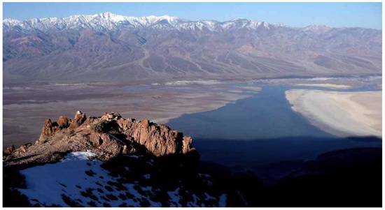
Even rain has fallen at Death Valley National Park since the first of the year that Lake Manly has reappeared, as this picture taken from Dantes View shows. NPS photo.
The guessing game on how significant the spring bloom in Death Valley National Park will be continues. No one is willing yet to say it will rival the 2005 showcase, but Park Service officials are predicting the "peak bloom," if there is one, will arrive in late March and into early April.
Spring 2005 gained venerated status among flower lovers for its incredible wildflower blooms in Death Valley. That bloom -- dubbed the "bloom of the century" -- was triggered by heavy fall and winter rains that dumped almost 6.5 inches of moisture on Death Valley.
According to park botanists, "the best time to see a spring floral display is in years when rainfall has been several times the Death Valley annual average of about 1.9 inches. In general, heavy rains in late October with no more rain through the winter months, will not bring out the flowers as well as rains that are evenly-spaced throughout the winter and into the spring."
From July 1, 2009, through February 17, rainfall at Furnace Creek measured roughly 2.75 inches, with just over 5 inches falling at Scotty's Castle. Most of that moisture has come since the first of the year, with Furnace Creek reporting right about 2.65 inches of rain during that time-frame, and Scotty's Castle reporting just under 4 inches.
Here's the latest wildflower report from the park:
The wildflower sprouts are still just tiny specks of green among the gravel and have a long way to go before any flowers appear. The most growth is in the central part of Death Valley where visitors may actually notice a “fuzz” of green on some slopes as they drive by. We are still predicting late March to early April for the peak bloom.
The Amargosa River has been flowing steadily into Death Valley from the south for the last few weeks. Water now covers the lowest salt flats of Badwater Basin to create a shallow lake about 8 inches deep (not enough to float a kayak) but about 3 miles wide. Lake Manly has returned!
Story Categories:
A copy of National Parks Traveler's financial statements may be obtained by sending a stamped, self-addressed envelope to: National Parks Traveler, P.O. Box 980452, Park City, Utah 84098. National Parks Traveler was formed in the state of Utah for the purpose of informing and educating about national parks and protected areas.
Residents of the following states may obtain a copy of our financial and additional information as stated below:
- Florida: A COPY OF THE OFFICIAL REGISTRATION AND FINANCIAL INFORMATION FOR NATIONAL PARKS TRAVELER, (REGISTRATION NO. CH 51659), MAY BE OBTAINED FROM THE DIVISION OF CONSUMER SERVICES BY CALLING 800-435-7352 OR VISITING THEIR WEBSITE. REGISTRATION DOES NOT IMPLY ENDORSEMENT, APPROVAL, OR RECOMMENDATION BY THE STATE.
- Georgia: A full and fair description of the programs and financial statement summary of National Parks Traveler is available upon request at the office and phone number indicated above.
- Maryland: Documents and information submitted under the Maryland Solicitations Act are also available, for the cost of postage and copies, from the Secretary of State, State House, Annapolis, MD 21401 (410-974-5534).
- North Carolina: Financial information about this organization and a copy of its license are available from the State Solicitation Licensing Branch at 888-830-4989 or 919-807-2214. The license is not an endorsement by the State.
- Pennsylvania: The official registration and financial information of National Parks Traveler may be obtained from the Pennsylvania Department of State by calling 800-732-0999. Registration does not imply endorsement.
- Virginia: Financial statements are available from the Virginia Department of Agriculture and Consumer Services, 102 Governor Street, Richmond, Virginia 23219.
- Washington: National Parks Traveler is registered with Washington State’s Charities Program as required by law and additional information is available by calling 800-332-4483 or visiting www.sos.wa.gov/charities, or on file at Charities Division, Office of the Secretary of State, State of Washington, Olympia, WA 98504.

National parks and their natural resources belong to you. The National Parks Traveler works to ensure you know how these essential places are being cared for.
Sign Up For Our Weekly Newsletter
Unsubscribe at any time.
INN Member

The easiest way to explore RV-friendly National Park campgrounds.

Here’s the definitive guide to National Park System campgrounds where RVers can park their rigs.
Our app is packed with RVing- specific details on more than 250 campgrounds in more than 70 national parks.
You’ll also find stories about RVing in the parks, tips helpful if you’ve just recently become an RVer, and useful planning suggestions.
