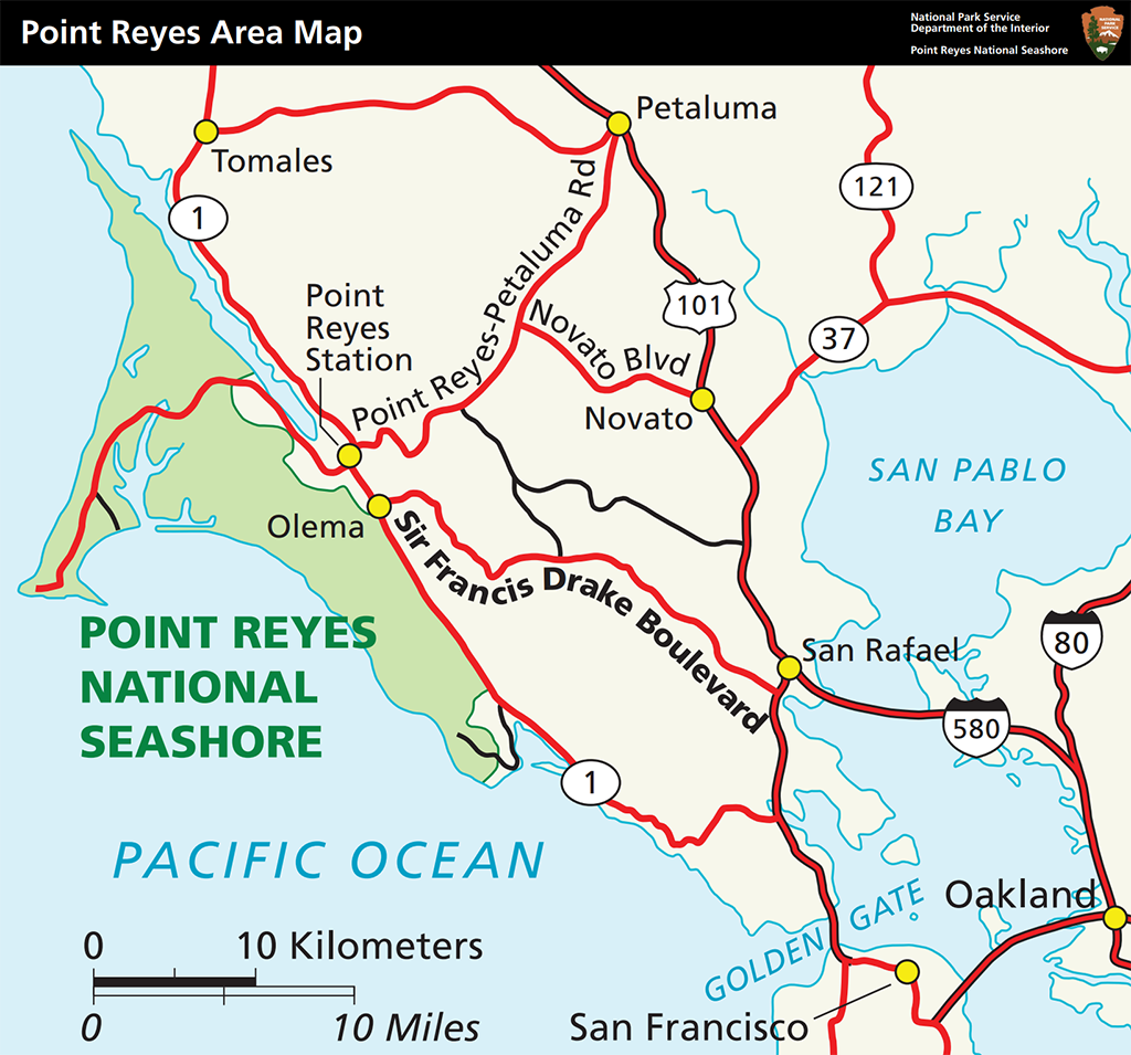
Getting to Point Reyes National Seashore in California is easy. This park is about 37 miles (59.5 kilometers) north of San Francisco along scenic Highway 1, 96 miles (154.5 kilometers) west of Sacramento, and 20 miles (32.2 kilometers) southwest of Petaluma, all in California.
If you intend to fly, then rent a vehicle to drive the rest of the way into the park, the airports with the largest selection of airlines (and rental car agencies) are the San Francisco International Airport (SFO), and Sacramento International Airport (SMF).
There is public transportation via the West Marin Stagecoach, which operates seven days a week between Inverness and San Rafael Transit Center along Sir Francis Drake Boulevard with a stop at the Bear Valley Visitor Center (the park’s main visitor center). For a full listing of bus routes and times, visit the West Marin Stagecoach website or call 415-526-3239.
Driving Directions
Directions from San Francisco
- From San Francisco, go north on U.S. Highway 101 across the Golden Gate Bridge.
- Follow U.S. 101 about 9 miles (14 kilometers) north of the Golden Gate Bridge to the Sir Francis Drake-San Anselmo exit, exit 450B.
- Make sure you are in the lane for San Anselmo (the second lane from the right) and exit onto Sir Francis Drake Boulevard heading west.
- Follow Sir Francis Drake west approximately 21 miles (33 kilometers)—passing through San Anselmo, Fairfax and Samuel P. Taylor State Park—until it intersects with Highway 1 at Olema.
- Turn right on Highway 1 and proceed north about 0.1 miles (0.2 kilometers) to the intersection with Bear Valley Road.
- Turn left onto Bear Valley Road and head west about 1/2 mile (0.8 kilometers). Look for a big red barn on the left and a sign for "Visitor Center; Headquarters; Information" on the right with an arrow pointing left.
- Turn left after passing by the red barn and proceed up the left-fork of the access road to the Bear Valley Visitor Center, the park's primary contact station.
Directions from the East Bay (San Francisco Bay Area)
- Follow Interstate 580 west across the Richmond-San Rafael Bridge.
- Shortly after the bridge, take the Sir Francis Drake Blvd. exit (the second exit after the bridge).
- Follow Sir Francis Drake west approximately 21 miles (33 kilometers)—passing through San Anselmo, Fairfax and Samuel P. Taylor State Park—until it intersects with Highway 1 at Olema.
- Turn right on Highway 1 and proceed north about 0.1 miles (0.2 kilometers) to the intersection with Bear Valley Road.
- Turn left onto Bear Valley Road and head west about 1/2 mile (0.8 kilometers). Look for a big red barn on the left and a sign for "Visitor Center; Headquarters; Information" on the right with an arrow pointing left.
- Turn left after passing by the red barn and proceed up the left-fork of the access road to the Bear Valley Visitor Center, the park's primary contact station.
Directions from Sacramento
- Follow Interstate 80 about 50 miles (80 kilometers) west toward Vallejo.
- Take Exit 33B to head west on California Highway 37 toward Novato/San Rafael.
- Be sure to merge into the left lane of the off-ramp, because the right lane quickly becomes an exit lane off Highway 37.
- From Interstate 80, follow California Highway 37 west about 19 miles (30 kilometers).
- Take the Black Point/Atherton Avenue exit, which is about 1 mile (1.6 kilometers) past the bridge over the Petaluma River. At the stop sign, turn left onto Atherton Avenue.
- Follow Atherton Avenue west 3.2 miles (5.1 kilometers). As the road crosses Highway 101, it becomes San Marin Drive. Continue west for about 2.5 miles (4 kilometers) to the junction with Novato Blvd.
- Turn right onto Novato Blvd. and proceed west for about 6 miles (10 kilometers) to the Point Reyes-Petaluma Road.
- Turn left and follow the Point Reyes-Petaluma Road southwest toward Point Reyes Station for about 7 miles (11 kilometers) to the junction with Platform Bridge Road.
- Continue straight onto Platform Bridge Road and wind your way south for 2.4 miles (3.8 kilometers) to the junction with Sir Francis Drake Boulevard.
- Turn right onto Sir Francis Drake Boulevard and drive west for 1.8 miles (2.9 kilometers) to the intersection with Highway 1 at Olema.
- Turn right on Highway 1 and proceed north about 0.1 miles (0.2 kilometers) to the intersection with Bear Valley Road.
- Turn left onto Bear Valley Road and head west about 1/2 mile (0.8 kilometers). Look for a big red barn on the left and a sign for "Visitor Center; Headquarters; Information" on the right with an arrow pointing left.
- Turn left after passing by the red barn and proceed up the left-fork of the access road to the Bear Valley Visitor Center, the park's primary contact station.
Directions from Petaluma
- From Highway 101, take the East Washington Street exit in Petaluma.
- Follow East Washington Street southwest about 0.6 miles (1 kilometer) to Lakeville Street.
- Turn left and proceed southeast one block to D Street.
- Turn right onto D Street, which will become the Point Reyes-Petaluma Road, and head southwest for about 16 miles (25 kilometers) to the junction with Platform Bridge Road.
- Continue straight onto Platform Bridge Road and wind your way south for 2.4 miles (3.8 kilometers) to the junction with Sir Francis Drake Boulevard.
- Turn right onto Sir Francis Drake Boulevard and drive west for 1.8 miles (2.9 kilometers) to the intersection with Highway 1 at Olema.
- Turn right on Highway 1 and proceed north about 0.1 miles (0.2 kilometers) to the intersection with Bear Valley Road.
- Turn left onto Bear Valley Road and head west about 1/2 mile (0.8 kilometers). Look for a big red barn on the left and a sign for "Visitor Center; Headquarters; Information" on the right with an arrow pointing left.
- Turn left after passing by the red barn and proceed up the left-fork of the access road to the Bear Valley Visitor Center, the park's primary contact station.
Bear Valley Parking
On weekends and holidays, the paved parking lot adjacent to the Bear Valley Visitor Center fills early. To help reduce traffic congestion in the paved parking lot, day hikers, backpackers, and other visitors who plan to spend more than thirty minutes in the Bear Valley area are encouraged to park their vehicles in the gravel parking lot on the left (east) side of the access road close to the Bear Valley Trailhead. (Download the Bear Valley Area Map)
There are no gas stations within the national seashore. The closest station to fuel your vehicle will be at Point Reyes Station just outside park boundaries, along Highway 1. This is where you will also find the only nearby auto repair station. Other gas stations may be found all along Highway 101.
Those of you driving electric vehicles (EVs) will be able to charge up at the Bear Valley Visitor Center.
According to Park Staff:
Six 240V electric vehicle charging stations with Tesla J3400 connectors (and J1772 adapters) are available for public use at the Bear Valley Visitor Center parking lot at Point Reyes National Seashore. You will need a mobile phone, a tablet (Apple or Android), or a Tesla to pay for use of the charging stations. The price will change seasonally as PG&E switches from winter to summer back to winter pricing rates. As of 2024, from October through May, the price is about $0.43/kWh. From June through September, the price is about $0.48/kWh.
Tesla vehicles come equipped to interface with the charging stations.
RVs and Trailers
Piloting an RV or trailer attached to a truck or SUV? Some roads are tricky to navigate within Point Reyes National Seashore and may be closed to both RVs/trailers. Also, while the smaller parking lots in the park appear to have sufficient space for an RV or vehicle/trailer combo, there might not be sufficient room to maneuver out of the parking lot without damaging other vehicles once that lot fills.
If you are traveling with a trailer or are driving an RV towing a passenger vehicle, consider unhitching at the bus/RV/trailer-only parking lot at Bear Valley and taking only the passenger vehicle for the drive out to the Lighthouse area.
While groceries and dining options are located within the communities outside the park, and both Bear Valley Visitor Center and Drakes Beach offer some pre-packaged food items (Drakes Beach also offers drinks), you should still bring water and food with you.
- By Rebecca Latson - December 2nd, 2025 1:08pm


