There’s plenty of history at Whiskeytown National Recreation Area in California, starting with the Wintu, who inhabited lands within what are now Whiskeytown’s borders for thousands of years. Then, the influx of European Americans, Chinese, and immigrants from other parts of the world, created a gold rush, a water rush, and a presidential visit down the road.
Whiskeytown
Let’s start with the name “Whiskeytown.” While the Wintu probably already knew of the gold deposits in the Whiskeytown area, it wasn’t until the late 1840s and early 1850s that news of gold brought thousands of people to California to mine these Sierra foothills. Small communities serving these miners sprang up, including the community of Whiskey Town (Whiskeytown).
According to local folklore, miner Billie Peterson’s mule was hauling supplies to Peterson’s home when the pack broke and a whiskey barrel tumbled downhill to crash at the bottom and empty its liquid contents into a creek now called Whiskey Creek. True or not, this story is a colorful reason for a town name, especially since whiskey was the drink du jour for the era.
Although never very large, Whiskeytown became a stopover for stagecoaches, pack trains, and people on their way to and from other destinations. By the 1870s, the major gold deposits petered out and ranching, farming, and businesses serving those travelers took over.
Even when the population dwindled, there were still enough inhabitants to warrant a postal code, although the U.S. Postal Service did not wish to use the name “Whiskeytown” because it was deemed “unwholesome.” Instead, it used names such as Stella, Blair, Whiskey Creek, and Schilling. Ultimately, in the early 1950s, the Women’s Improvement League of Whiskeytown successfully campaigned to have the Whiskeytown name officially adopted by the Post Office.
Whiskeytown Cemetery
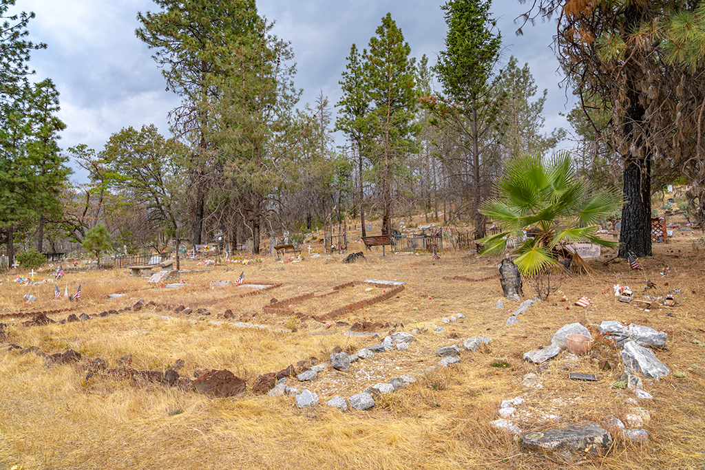
You might not think this an interesting stop during your visit to this national recreation area, but when you think about it, cemeteries are literally storehouses of human history. Drive the J.F. Kennedy Memorial Drive to the Gloryhole Spillway, turn left onto Paige Bar Road, and continue approximately one mile (1.61 kilometers) to the Whiskeytown Cemetery. Here, whimsy meets history. In 2000, reporter Kevin Fagan for SFGate, wrote about “The Quirky And The Dead,” where you can visit gravesites that include the earthly remains of Whiskeytown inhabitants from the 1800s to the present.
Set deep in the mountains above Redding and Whiskeytown Lake, this is where the bones of 19th century pioneers take eternal sleep beside babies, farmers, bikers, cowboys and other recently departed inhabitants of the modern world. There are about 800 graves in colorful profusion in this free-form arena of grief, but it is so isolated that most people do not even know it exists.
During the early 1960s, When the Whiskeytown Dam was constructed and flooded the town to make Whiskeytown Lake, the cemetery was moved to its present location and bodies were exhumed then reinterred. In 2018, the Carr Fire completely burned down the Whiskeytown General Store while significantly damaging the cemetery.
Today, Whiskeytown is a ghost town beneath the lake, but you can still visit the cemetery and pay your respects to its inhabitants.
Tower House Historic District
Near the northwestern border of Whiskeytown National Recreation Area, along California State Route 299 about 7.5 miles (12 kilometers) west of the Whiskeytown Visitor Center, is the Tower House Historic District. Park your car in the paved lot and walk across the bridge spanning Clear Creek to the historic Camden House, spared from the 2018 Carr Fire.
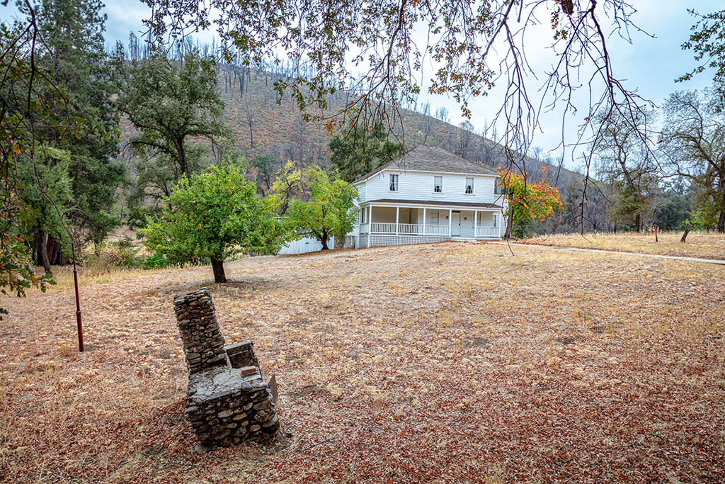
Built by Charles Camden in 1852 at the beginning of the California Gold Rush, Camden House served as home to Charles and Philena Camden (nee Tower), sister of Camden’s friend and mining partner Levi Tower.
According to Park Staff:
Charles Camden was among those drawn to California by gold. He settled on the banks of Clear Creek in 1850 and mined successfully. He also made money with a sawmill, toll road, water ditch, silver mine, and investments. Camden lived to age 95. His obituary described him as "the most prominent man in the business affairs of Shasta County from the earliest days."
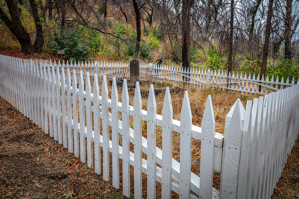
Charles’ friend Levi Tower was not quite as successful in business or in matrimony. Although he built the Tower House Hotel (which burned down in 1919) and planted a substantial fruit orchard within what are now the park’s borders, Tower was eventually forced to sell the hotel and orchard to stay financially afloat.
His marriage to Mary Shuffleton was short lived and divorce followed, with former wife Mary remarrying soon thereafter. Tower did have the distinction, however, of being the first divorcee in Shasta County history. You can hike to Tower's gravesite, at the foot of a hill, set back a ways behind the Camden House.
Wintu And Settlers
As mentioned earlier, the Wintu people inhabited this landscape for thousands of years prior to the arrival of white Europeans. It didn’t go well between the Wintu and the settlers.
According to Park Staff:
The Gold Rush dramatically impacted indigenous people. The vast majority were killed in campaigns of extermination or died from disease and starvation. Scholars estimate the population went from 150,000 in 1845 to 30,000 in 1870.
As was common at the time, the Camdens engaged in practices reflective of the period’s societal norms, including the purchase of Native Americans as servants. One such individual was Kate, a young Wintu girl who came to be known as Kate Camden. Her story, like many others, is a reminder of the exploitation and hardships endured by Native American communities during this era.
You can hike the Camden Water Ditch Trail, a portion of which is paved with interpretive signage explaining the history of the area. This trail leads you around Camden House to the fenced gravesite of Camden’s friend Levi Tower. You’ll also walk past the barn, sawmill, and tenant farmhouse.
Gold Panning
If you feel like partaking of a little Whiskeytown history, you can pan for gold in the park.
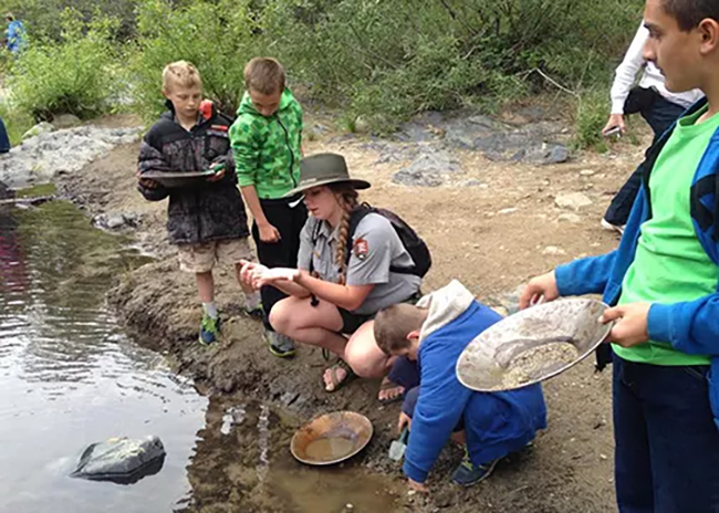
According to Park Staff:
Recreational gold panning is allowed at Whiskeytown, but you'll need to purchase a permit and follow park regulations. The permit costs one dollar and is valid for one year from the date of purchase. Anyone 17 years or older must have a permit while gold panning, and an entrance pass is also required.
Gold panning in the park is limited to the use of a metal or plastic gold pan and small digging tools, such as a trowel or spoon, with blade surfaces no larger than 4 inches wide and 8 inches long.
The following activities are prohibited under the Code of Federal Regulations:
- Use of metal detectors, suction devices, sluice boxes, rockers, dredges, and other mechanical or hydraulic tools.
- Use of skin-diving equipment (snorkels, masks, wetsuits, etc.).
- Use of toxic substances or chemicals, including mercury.
- Sale or commercial use of minerals recovered while gold panning.
- Digging above existing stream water levels or disturbing the ground surface.
- Undermining vegetation, historical features, or bridge abutments.
You can purchase a permit at the park’s visitor center or online at recreation.gov.
OK, so you have your permit and pan, now where’s a good place to look for gold? The park recommends the Tower House Historic District, where Mill Creek, Crystal Creek, and Clear Creek converge. Clear Creek Picnic Area on Trinity Mountain Road is another favorite place for panning.
Note: gold panning is not allowed along Clear Creek from the mouth of Paige Bar Creek to the Whiskeytown Environmental School Camp access road bridge. This restriction is in place to prevent disruption to educational programs at the environmental school.
- By Rebecca Latson - October 4th, 2025 5:45am


