How to get to Sequoia and Kings Canyon National Parks in California depends upon which of the three entrances you choose. Whichever entrance becomes your arrival destination, bear in mind that GPS devices and online map directions are not always trustworthy, leading you to a road out in the middle of nowhere rather than a park entrance.

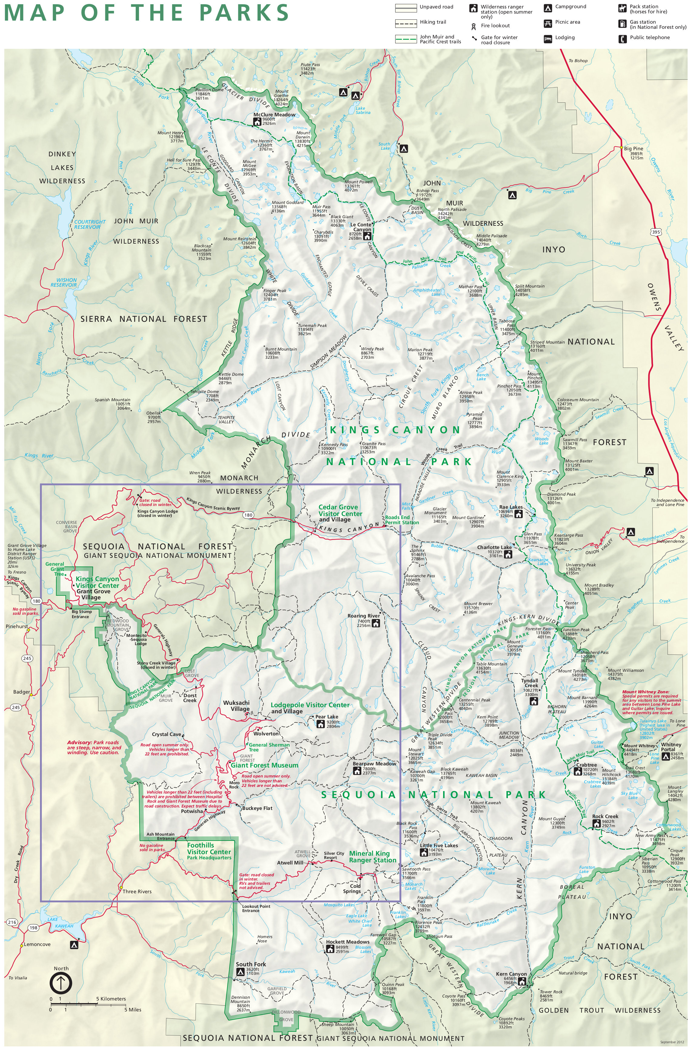
Park Entrances
Ash Mountain Entrance to Sequoia National Park
- Highway 198 enters Sequoia National Park at the town of Three Rivers. Beyond the entrance station, the road is narrow and winding.
- Vehicles longer than 24 feet (7.3 meters) are not advised between the Foothills Visitor Center and Potwisha Campground. Vehicles longer than 22 feet (6.7 meters) are not advised between Potwisha Campground and the Giant Forest Museum.
Big Stump Entrance to Kings Canyon National Park
- Highway 180 enters Kings Canyon National Park from the west via Fresno.
- Highway 180 is the preferred route for longer vehicles. It is straighter, less steep, and wider.
Lookout Point Entrance to the Mineral King Area
- If you're heading to the remote Mineral King area of Sequoia National Park, look for the junction of Mineral King Road with Highway 198 in the town of Three Rivers, two miles (3.2 kilometers) before the Ash Mountain Entrance.
- This road is extremely narrow and winding and is unpaved in some areas. RVs and trailers are not advised and are not permitted in the campgrounds.
- Only trails connect Mineral King with the rest of Sequoia National Park. No roads cross the mountains west-to-east through Sequoia and Kings Canyon National Parks.
For a closer, more detailed look at the park map and its entrances, click here.
Flying

The closest commercial airports – all located in California - with a wide selection of airlines will be the Fresno Yosemite International Airport approximately 51 miles (82 kilometers) from the parks and the San Francisco International Airport approximately 241 miles (388 kilometers) away. There are two smaller airports nearby: the Meadows Field Airport in Bakersfield a little under 100 miles (161 kilometers) from the parks, and the Visalia Municipal Airport approximately 40 miles away. Bear in mind, these two smaller airports have a limited airline selection and fewer flights.
Driving
According to Park Staff:
- If you drive to these parks, be prepared for driving mountain roads that are steep, narrow, and winding. Length limits and advisories are in place for RVs, trailers, and any other vehicles over 22 feet (6.8 meters) in length. If you drive an RV or a vehicle with a trailer, check advisories before you visit.
- No gasoline is sold within the parks, though there are gas stations at nearby national forests. Depending on your vehicle, electric vehicle (EV) charging stations may be available at park lodges, [but you’ll find the most EV charging stations in the nearby communities outside park borders.]
- Access to park roads varies by season. Tire chains may be required on park roads any time it snows, usually late fall, winter, and through spring. Chains are available for purchase or rent at locations near park entrance stations. Learn more about chains and other winter driving information before you plan your visit.
- Due to heavy visitation, be prepared for delays at park entrances. In summer, on Fridays, Saturdays, and on holidays from Memorial Day to Labor Day, long lines of cars have extended from the entrance stations. Learn how to plan for a wait at the entrance station.
- There are no roads in these parks that cross the Sierra Nevada mountain range. To help plan your route, check our driving map of the parks and regional maps of the area.
Road Directions
To Kings Canyon National Park's Big Stump Entrance (Highway 180)
City | Distance | Time | Directions |
Fresno | 60 mi/97 km | 1 hour, 15 minutes | Take CA-180 E to the Big Stump entrance of Kings Canyon National Park. |
San Fransisco | 250 mi/402 km | 4 hours, 30 minutes | Take I-80 E to I-580 E. Continue onto I-205 E, merge onto I-5 N. Take CA-120 E to CA-99 S. Then take exit 133B onto CA-180 E. Continue to the Big Stump entrance of Kings Canyon National Park. |
San Jose | 217 mi/349 km | 4 hours | Take CA-85 S and merge onto US-101 S. Take exit 356 onto CA-152 E. Take CA-99 S. Take exit 133B onto CA-180 E. Continue to the Big Stump entrance of Kings Canyon National Park. |
Sacramento | 240 mi/386 km | 4 hours, 15 minutes | Take US-50 E/CA-99 S towards Fresno. Take exit 133B onto CA-180 E. Continue to the Big Stump entrance of Kings Canyon National Park. |
Reno | 365 mi/587 km | 6 hours, 30 minutes | Take I-80 W towards Sacramento. In Sacramento, take CA-99S. In Fresno, take exit 133B onto CA-180 E. Continue to the Big Stump entrance of Kings Canyon National Park. |
Lake Tahoe | 330 mi/531 km | 6 hours | From South Lake Tahoe take US-50 W towards Sacramento. In Sacramento, take CA-99S. In Fresno, take exit 133B onto CA-180 E. Continue to the Big Stump entrance of Kings Canyon National Park. |
Yosemite Entrance | 130 mi/209 km | 2 hours, 30 minutes | Take CA-41 S toward Fresno. In Fresno, take exit 128 onto CA-180 W. Merge onto CA-180 E. Continue to the Big Stump entrance of Kings Canyon National Park. |
To Sequoia National Park's Ash Mountain Entrance (Highway 198)
City | Distance | Time | Directions |
Visalia | 36 mi/58 km | 45 minutes | Take CA-198 E to the Ash Mountain entrance of Sequoia National Park. |
Los Angeles Area | 225 mi/362 km | 4 hours | Take any highway to I-5 N. Continue onto CA-99 N toward Bakersfield/Fresno. Take exit 96 onto CA-198 E towards Visalia. Continue to the Ash Mountain entrance of Sequoia National Park. |
San Diego Area | 344 mi/538 km | 5 hours, 50 minutes | Take I-805 N or I-5 N to CA-99N toward Bakersfield/Fresno. Take exit 96 onto CA-198 E towards Visalia. Continue to the Ash Mountain entrance of Sequoia National Park. |
Las Vegas | 400 mi/644 km | 6 hours, 30 minutes | Take I-15 S towards Los Angeles. Take exit 179 onto CA-58 W towards Bakersfield. In Bakersfield, continue onto CA-99 N toward Fresno. Take exit 96 onto CA-198 E towards Visalia. Continue to the Ash Mountain entrance of Sequoia National Park. |
Death Valley National Park (West Entrance) | 310 mi/499 km | 5 hours 25 min | CA-190 W to US-395 S and turn left. Continue onto CA-14S. Turn right at CA-58 W. Take the ramp onto CA-99 N. Take exit 96 onto CA-198 E towards Visalia. Continue to the Ash Mountain entrance of Sequoia National Park. |
Arriving by Bus
- Greyhound Lines stops in the city of Visalia at the Visalia Transit Center, and in the City of Fresno at the Fresno Greyhound Station. Once in Visalia, it's possible to connect with park shuttle routes in summer to take you to Sequoia National Park. In other seasons, renting a vehicle is an option.
- The City of Visalia's V-Line bus route provide service between the Visalia Transit Center and Fresno-Yosemite International Airport., with additional stops at Fresno State University and the Visalia Municipal Airport. In summer, this route connects with the Sequoia Shuttle.
- Tulare County Area Transit offers service from the Visalia Transit Center to the Memorial Building in the town of Three Rivers. Many companies begin guided sightseeing tours in Three Rivers. There are many private companies offering guided tours of the parks by charter bus.
- By Rebecca Latson - July 15th, 2025 1:40am


