

Since 1966, national scenic and historic trails have been an American priority. They traverse mountains, canyons, forests, and grasslands across the country, crossing creeks and rivers and skirting lakes.
These narrow corridors through the wilderness provide recreation and protect historic resources while conserving natural features. There are many physical, emotional, and logistical requirements for these trips, and winter is the perfect season to get in shape and plan for a long walk. Here’s a quick look at a few of these trails to help you plan a trip.
Appalachian National Scenic Trail
The granddaddy of long-distance trails, the A.T. runs from Mount Katahdin in Maine to Springer Mountain in Georgia, a distance of more than 2,180 miles. Head out to hike the entire distance and you’ll pass through urban areas, regions that still bear vestiges of wilderness, and come upon 260 huts or lean-tos spaced about a day’s walk apart.
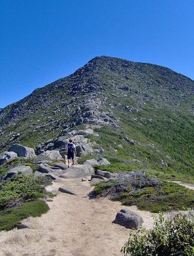
People sample sections of the trail, or do the whole thing, either north to south or the more popular south to north, which follows the weather. The A.T. passes through Great Smoky Mountains National Park, the Blue Ridge Parkway, Shenandoah National Park, and the Delaware Water Gap National Recreation Area.
To understand what you’re getting into, download a copy of the Appalachian Trail Thru-Hiker’s Companion. This small book, relied on by many hikers for 25 years, has details on shelters, water sources, post offices, hostels, campgrounds, showers, lodging, groceries, restaurants, outfitters, and other related services along the trail. It provides information on elevation, describes of areas of historical significance, and contains nearly 50 maps. Produced through a collaboration of the Appalachian Trail Conservancy and the Appalachian Long Distance Hikers Association, you can purchase a copy for $15 from the Conservancy’s website.
While the National Park Service oversees the trail, the Appalachian Trail Conservancy maintains it and stands ready to help you plan your journey. Whiteblaze is an online forum for trail hikers and offers some helpful information and a sounding board for your questions.
Good Reads: Bill Bryson’s A Walk in the Woods is a classic for aspiring, as well as veteran, A.T. hikers.
Though the U.S. Forest Service oversees the Arizona National Scenic Trail that stretches 800 miles north-and-south along the entire length of the state, the trail passes through such National Park Service properties as Grand Canyon National Park, Walnut Canyon National Monument, Tonto National Monument, Saguaro National Park, and Coronado National Memorial.
This non-motorized trail, open to hikers, mountain bikers, and equestrians, leads you across desert landscapes, through deep forests you might expect to find a state or two farther north, and into incredible wilderness areas.
You’ll walk along the Gila River, through the Superstition Mountains, along the Mogollon Rim, and even across the Grand Canyon.
One of the best resources is the Arizona Trail Association, which can point you to shuttle companies, the 43 “passages,” or sections, of the trail, and even water sources along the way, an immeasurable resource.
Continental Divide National Scenic Trail
This is a perhaps America’s most challenging trail, rambling from Canada to Mexico, a distance of 3,100 miles. Even if you hiked 17 miles a day (probably unreasonable for most of us), it would still take you six months to walk. The trail is dramatic, diverse, and at times very rugged.
At this time, not quite 80 percent of the trail is complete. That which is courses through mountain meadows, over granite peaks, and across high deserts. Only well-experienced backpackers, those comfortable with route finding and bushwhacking, should tackle this end-to-end. If you can claim that experience, with a good map, compass, and planning you should be able to follow this trail close to the Continental Divide.
Your gear should be diverse enough to help you navigate both high country snowfields and searing desert heat. As with many of the other trails, you’ll need to develop a mail drop schedule for resupply, as most people can only carry a week’s supply of food. You also might want to ship ahead other gear, such as stove parts, maybe snowshoes, ropes, and new hiking boots. Before you head down the trail, contact these mail drop spots to make sure they will be open and available when you plan to pass through.
The trail will take you through the grandeur of Glacier, Yellowstone, and Rocky Mountain national parks, as well as into the El Malpais National Monument.
A great resource for preparing for this trail is the Continental Divide Trail Alliance, which can help you with trip planning tips ranging from shuttles to water sources and books from those who have accomplished this journey.
The Continental Divide Trail Alliance works to build and maintain sections of the trail, and also offers maps and guides to help you find your way.
This 1,300-mile trail extends from Big Cypress National Preserve in South Florida through Florida’s three national forests to Gulf Islands National Seashore in the western panhandle. It passes through America’s only subtropical landscape as well as globally significant scrub and longleaf pine ecosystems. To get a sense of the lay of the land along this trail, check out this interactive program the U.S. Forest Service put together.

During the last Ice Age 15,000 years ago, mammoths, saber-toothed cats, and cave lions called this landscape now known as Wisconsin home. The 1,200-mile trail travels navigates this glacially carved country, passing lakes, rambling through river valleys, and running ridges.
To prepare for this trek, check out the Ice Age Alliance website. There you’ll find a glossary for some of the landscape features you’ll pass—e.g., “Dells/Dalles: A gorge cut by torrents of meltwater released by a melting glacier or draining of glacial lakes”—maps, guidebooks, and apps, and much more.
North Country National Scenic Trail
This trail passes through seven states (Michigan, Minnesota, North Dakota, Ohio, Pennsylvania, and Wisconsin). You can backpack the whole thing, or walk stretches of it through valleys and over hilltops, past small towns and cities, enjoying the scenic beauty and learning about historic sites.
The North Country Trail Association’s website is a good place to start thinking about tackling this 4,600-mile trail. There you’ll find maps and guides as well as links to download GIS data as well as waypoints. Of course, you also can go old school and buy section maps from the organization.
Overnight campsites are first comefirst served, but plan ahead. You will need backcountry permits within the Pictured Rocks National Lakeshore in Michigan and along the Kekekabic and Border Route trails within the Boundary Waters Canoe Area Wilderness.
Pacific Crest National Scenic Trail
This incredible trail goes from the rain forests of the Northwest near the U.S.-Canadian border to the searing deserts of California that adjoins Mexico. It rises from near sea level to the heights of the Sierra Nevada and Cascade mountain ranges. It is deemed much more demanding than the Appalachian Trail, with only about half the number of thru-hikers as its eastern cousin.
Along its 2,650 miles you’ll pass through portions of Mount Rainier, Crater Lake, Lassen Volcanic, Yosemite, Kings Canyon, and Sequoia national parks, as well as Devils Postpile National Monument.
If you think you want to set off from Mexico to Canada, definitely visit the Pacific Crest Trail Association’s permit page. You will need to obtain permits for some national forests, state parks, and, of course, national parks. There’s also a list of “mentors,” who have hiked the entire trail, for advice and answers to your questions. Read here, how hiker Rod Johnson walked the trail with only a nine-pound pack.
Good reads: The Pacific Crest Trailside Reader, California, and The Pacific Crest Trailside Reader, Oregon and Washington.

Pacific Northwest National Scenic Trail
This 1,200-mile trail travels from Glacier National Park to the Pacific Ocean, passing through some of this country’s most pristine landscapes. It’s a primitive trail for those with backcountry experience and a thirst for adventure. You’ll walk through Montana, Idaho, and Washington before reaching Cape Alava on the Pacific Coast in Olympic National Park.
To start your planning, visit the Pacific Northwest Trail Association website where you’ll find details on the trail as well as maps and even photos. Visit the U.S. Forest Service website on the trail and you’ll find maps that provide an overview of trail sections, but which are not intended for navigating your way.

This 93-mile loop trail circumnavigates Mount Rainier National Park with incredible landscapes and many elevation gains, up to 3,000 feet in one day. You may at times traverse old logging roads, clear-cut timber areas, and even see city lights off in the distance. You’ll also encounter wildlife and the scenic beauty of this incredible park.
You might start from Fryingpan Creek on up the White River Road for a few days, camping at one of the 18 designated campsites, such as Summerland and Indian Bar with their rock shelters. Make sure you take the 1.5-mile side trip to Snow Lake as you leave the comforts of the Paradise Inn. The most scenic camps are at Golden Lakes, Devils Dream, and Klapatche Park.
As enticing as this trail might seem, it’s understandable that you’re not the only one drawn to it. The National Park Service runs a reservation program to dole out permits in an effort to limit usage. Check out how to apply at this page. (https://www.nps.gov/mora/ planyourvisit/wilderness-permit.htm)
Good Read: Hiking The Wonderland Trail by Tami Asars.
There you have it. Enough trails to keep you busy for a few years at least. After that, trail networks in the National Park System offer thousands of more miles to walk. But that’s another story.
Stories about:
Story Categories:
A copy of National Parks Traveler's financial statements may be obtained by sending a stamped, self-addressed envelope to: National Parks Traveler, P.O. Box 980452, Park City, Utah 84098. National Parks Traveler was formed in the state of Utah for the purpose of informing and educating about national parks and protected areas.
Residents of the following states may obtain a copy of our financial and additional information as stated below:
- Florida: A COPY OF THE OFFICIAL REGISTRATION AND FINANCIAL INFORMATION FOR NATIONAL PARKS TRAVELER, (REGISTRATION NO. CH 51659), MAY BE OBTAINED FROM THE DIVISION OF CONSUMER SERVICES BY CALLING 800-435-7352 OR VISITING THEIR WEBSITE. REGISTRATION DOES NOT IMPLY ENDORSEMENT, APPROVAL, OR RECOMMENDATION BY THE STATE.
- Georgia: A full and fair description of the programs and financial statement summary of National Parks Traveler is available upon request at the office and phone number indicated above.
- Maryland: Documents and information submitted under the Maryland Solicitations Act are also available, for the cost of postage and copies, from the Secretary of State, State House, Annapolis, MD 21401 (410-974-5534).
- North Carolina: Financial information about this organization and a copy of its license are available from the State Solicitation Licensing Branch at 888-830-4989 or 919-807-2214. The license is not an endorsement by the State.
- Pennsylvania: The official registration and financial information of National Parks Traveler may be obtained from the Pennsylvania Department of State by calling 800-732-0999. Registration does not imply endorsement.
- Virginia: Financial statements are available from the Virginia Department of Agriculture and Consumer Services, 102 Governor Street, Richmond, Virginia 23219.
- Washington: National Parks Traveler is registered with Washington State’s Charities Program as required by law and additional information is available by calling 800-332-4483 or visiting www.sos.wa.gov/charities, or on file at Charities Division, Office of the Secretary of State, State of Washington, Olympia, WA 98504.
Comments
Let's hear it for the Mountains-to-Sea Trail across North Carolina www.mountainstoseatrail.org.
About 1,100 miles from Clingmans Dome in Great Great Smoky Mountains National Park to Jockey's Ridge State Park just outside Cape Hatteras National Seashore. You'are not just walking between two sets of trees, but pass historic sites, other national park units, small towns and lakes.
Danny Bernstein
www.hikertohiker.com
The Continental Divide Trail COALITION is actually the current overseeing body of the CDT.
Coincident with the CDT for300+ miles is the 500 miles long Colorado Trail, which has two alternate routes thru the Cllegiates Wilderness. Denver to Durango. Fabulous. Bikes allowed in non Wilderness areas. Colorado Trail foundation is the place to go for maps and guides
Guthook has apps for all the major trails.