

Before the park, there’s the entrance booth. You’re greeted by a National Park Service ranger, who hands over a newsletter and a map. You know the map – the size of a brochure, a black stripe lines one edge, the park’s name across it in white type. At the same time familiar and stimulating, an iconic photo tempts you to unfold it, panel by panel unveiling the breadth of opportunities that await.
This is your first souvenir from the park.
“Receiving that map means I am now in a crown jewel; I am experiencing the best of what America has to offer and what this nation most values,” said Matt Holly, who works at the National Park Service’s Natural Resource Stewardship and Science Directorate in Colorado. “There's a sense of pride and ownership that goes with the map the ranger hands over.”
Mr. Holly is a lifelong parks and maps enthusiast. As a child, exploring the boardwalks of Yellowstone National Park rivaled the enchantment of Disneyland. On multi-week family road trips, he flipped through an AAA TripTik and “always wanted to know what was coming next.” Eventually, inspired by those early vacations to Yellowstone, he got a degree in geology and became a ranger for the Park Service.
During the government shutdown of 2013, with plenty of free time on his hands, Mr. Holly put his interests together and launched the website National Park Maps. The idea was to build a hub for browsing and downloading maps from all of the national parks without having to visit multiple websites, even though he had no idea how to develop a website at the time.

NPMaps.com has more than 1,000 national parks maps.
Two-and-a-half years later, many milestones have been met. In early April, Mr. Holly loaded maps for four Alaska parks, completing the goal of representing all 59 national parks. But he hasn’t stopped there. A couple weeks later, he surpassed 1,000 total maps. In between, he added an interactive map for each location. When he shared his creation on the Camping and Hiking Subreddit, it shot to the top of the charts and received “overwhelmingly positive feedback.”
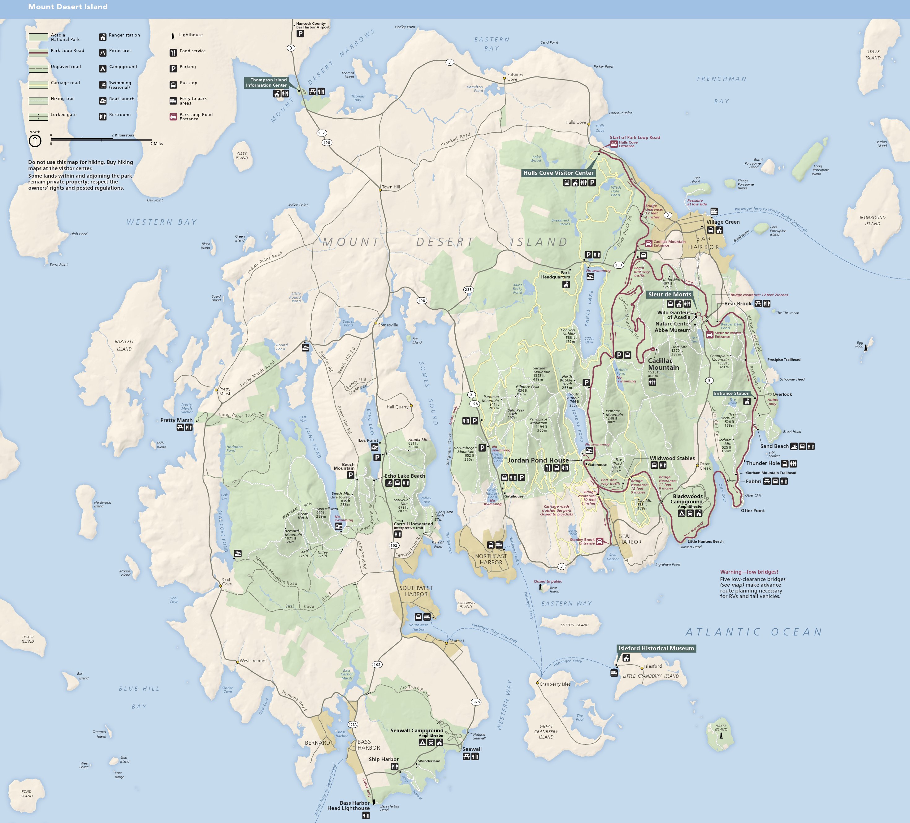
“It's very gratifying to know my work is helping others better plan their national park visits,” said Mr. Holly, who thinks Utah’s Canyonlands National Park, with its dizzying number of activities for all types of visitors, “epitomizes what a national park should be.”
Still, the website “only” features 93 of 411 Park Service units, so there’s plenty to keep him busy. Unlike his road trips to national parks, Mr. Holly doesn’t have a set plan or timeline for adding locations. Instead, he generally has “a burst of energy” and creates several new pages at once. In his latest blog post, Mr. Holly said he hopes to have all the units with maps on the site by 2019.
He views his project, which he maintains in his free time, as a complement to NPS.gov, allowing visitors to quickly find lots of maps in a variety of file formats for each park unit. When he started working on NPMaps, the official Park Service websites didn’t have a set location to easily find maps. A system-wide redesign last year improved the experience, requiring each unit to have a page devoted to maps, and another update this year has a Maps link prominently featured on each unit’s home page.
Mr. Holly adds a personal touch to all the maps he posts, most of which are from the Park Service or in the public domain. He removes excess text, improves image quality, and creates thumbnails and descriptions for every map. He links to nearby parks to help with trip planning. In addition to updates, his blog offers interesting tidbits and data about NPMaps.
Beyond the full park maps, there are detailed maps of specific components of a park, such as hiking trails or campgrounds, while others offer a broader view of the area surrounding a park. More fun and interesting ones colorfully outline the underground network of passages and tunnels at Jewel Cave National Monument and the depth of Crater Lake. No page features fewer than three maps. As of now, the Grand Teton National Park page includes the most, with 38. Mr. Holly doesn’t expect that to last, however.
“I have more maps waiting in the wings for other parks that will push them past Grand Teton, but many of them are in time-consuming formats to convert and prepare for upload,” he said.
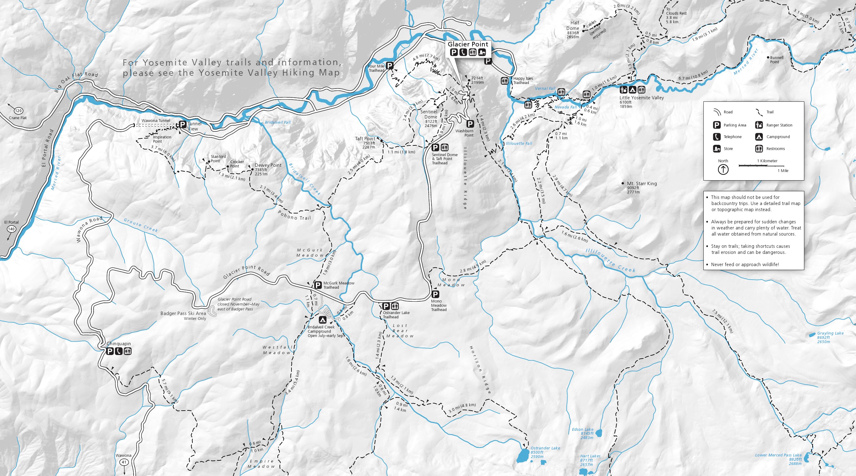
Mr. Holly has been a park ranger since 2005, with stints at Sequoia, Acadia, Voyageurs, and Yosemite, where he had 15 minutes of fame in 2013. That’s also where he created his first map for the Park Service, a trail map of Glacier Point Road.
“Sure, it's not the most beautiful map in the world, as I had some design requirements to meet in terms of map scope and printing process,” he said. “But it was the first one I designed, and it's incredibly rewarding knowing it's being passed out at park visitor centers.”

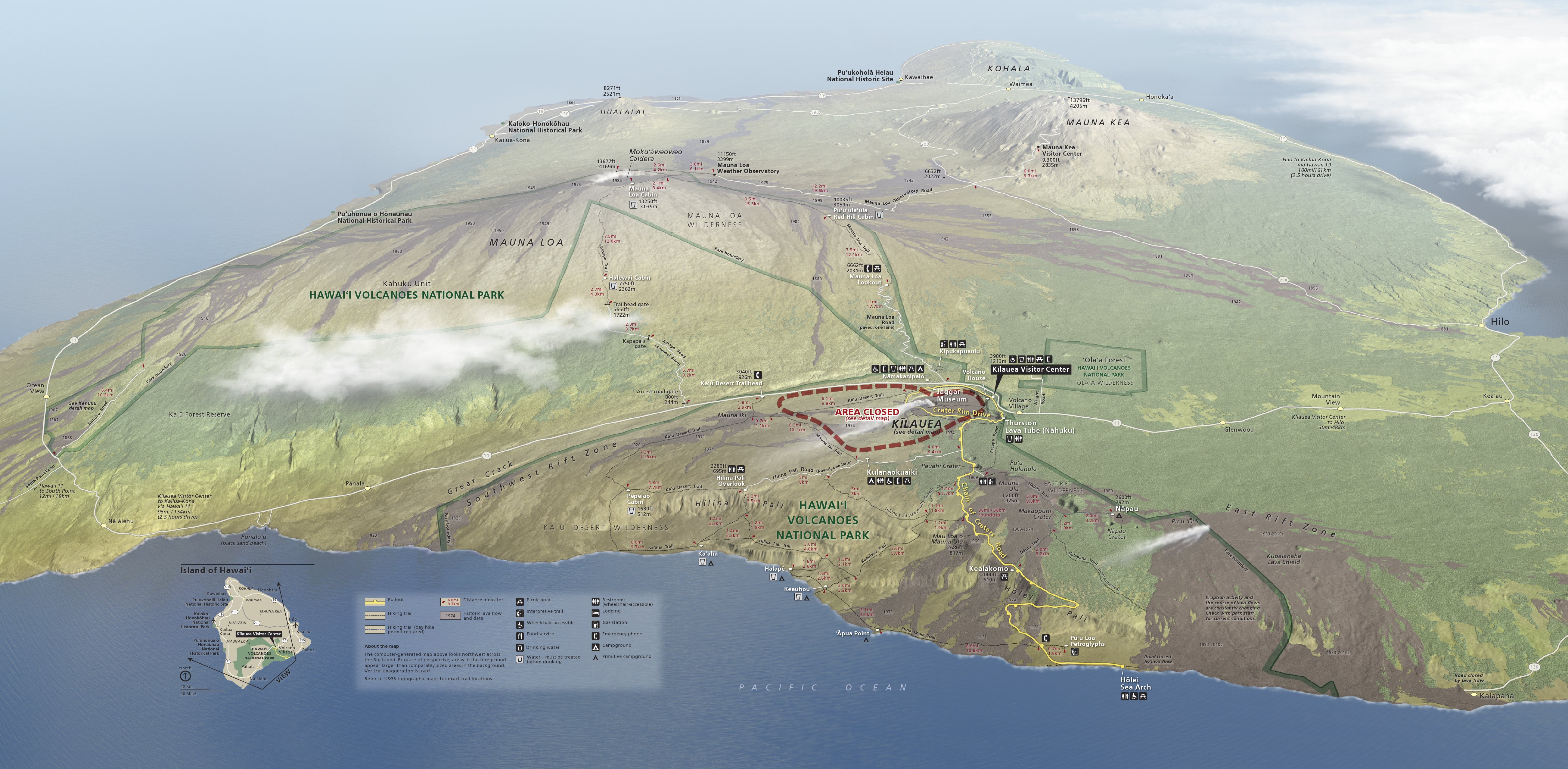
The Hawaii Volcanoes National Park official unigrid map/NPS
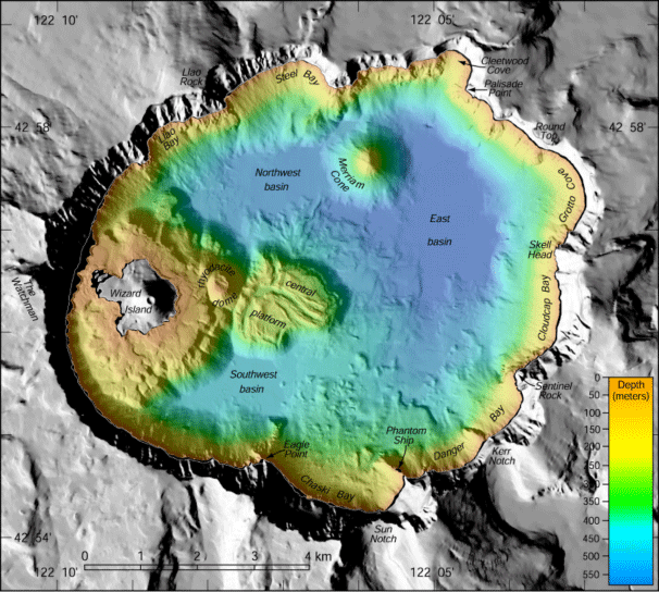
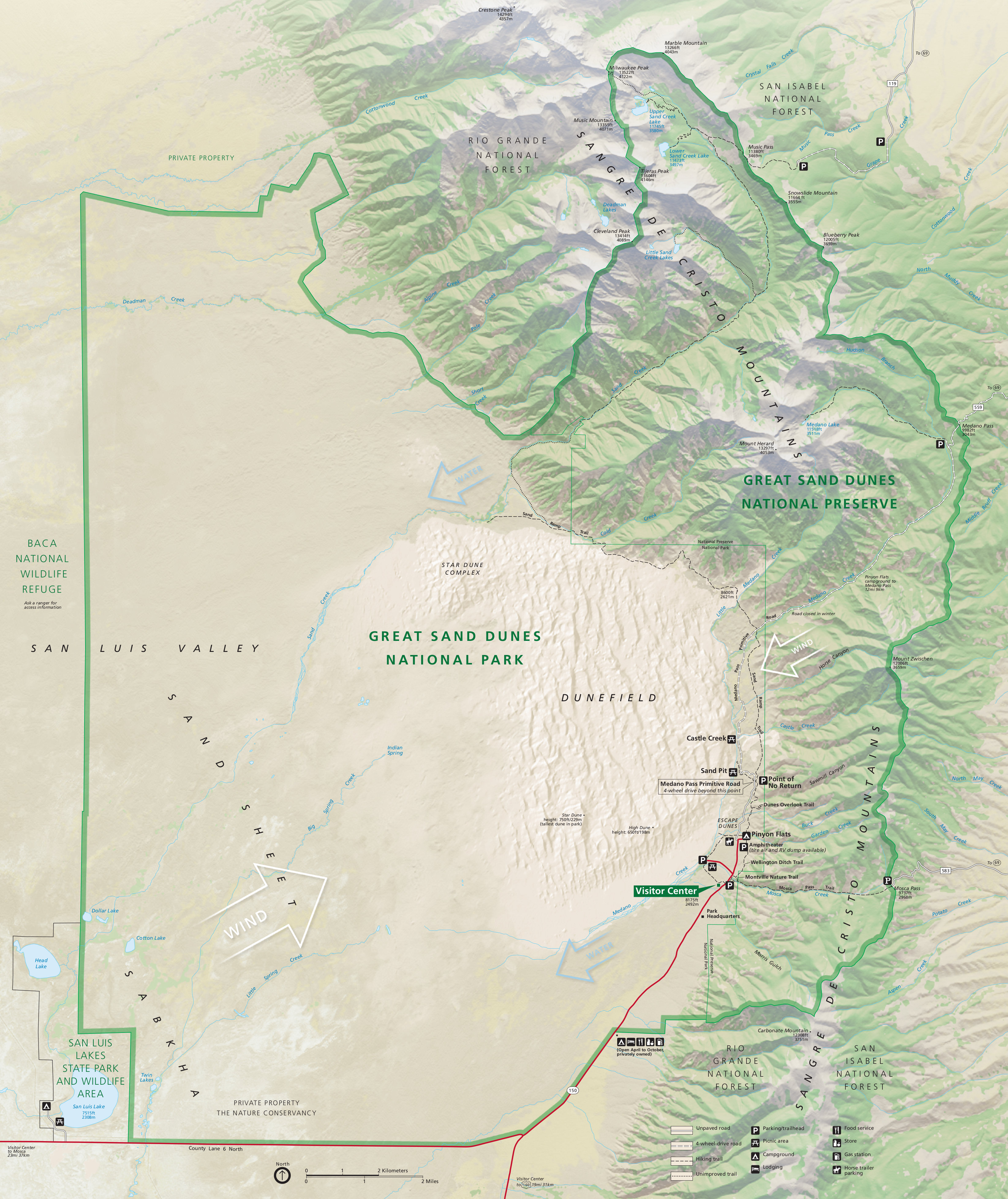
As for other favorites on the site, there’s the official unigrid map from Hawaii Volcanoes National Park, which shows the entire island from an angled perspective: “You can see the five volcanoes that make up the Big Island; you can see the various lava flows (and their dates!) from the recently active volcanoes; you can see vegetation change according to elevation and aspect.” And for a more traditional, top-down map, he likes the one from Great Sand Dunes National Park: “An excellent combination of educational information and attractive colors while still being easy to navigate.”
One thing that draws Mr. Holly to maps is how much you can learn from them beyond where you’ve been and where you’re going. The shapes, locations, patterns and labels combine to tell a story.

The Acadia National Park map/NPS
“When I led geology hikes in Acadia, I'd have my visitors figure out where the continental glaciers came from just by looking at the park map,” he said, noting that you'll see the fjords, lakes, and mountains all generally point the same direction. “And each time you learn something, you look at a map with a new set of eyes and might see things totally differently. You can never truly be ‘finished’ reading a map.”
While Mr. Holly’s website focuses on digitized maps, and digital tools have made mapping more powerful and accessible, he still has an affinity for physical maps.
“Even though electronic maps are useful and convenient, I think there will always be a place for physical copies,” he said. “Sure, I like to view maps at home for trip planning and save them to my phone so they're always in my pocket. But nothing compares to unfolding the map, spreading it out on the table, and plotting your day’s adventure.”


Comments
This makes me smile. I have a rubber-banded stack of NP maps that's about 6" thick, and I just keep adding to it. I suspect I'm one of a lot of people who do this.
Awesome........ We are trip planning now from PA to AK. These will be a tremendous help to us.
This is a nice effort, but note that the NPS had already neatly catalogued all their map resources at the little known URL: nps.gov/carto
i, too, have a fat stack. I go one step further and put the park date stamp, (the one for the Passport) on the map, reminding me of when I was there. I look at them from time to time when home.
I think "little-known" are the key words here, regarding NPS cataloguing their own maps. At least, with this article, Mr. Holly's site is out there as another resource - one which I have bookmarked.
Little known, but not for to my readers, since I shared that resource on my blog half a decade ago:
http://www.terragalleria.com/blog/free-maps-of-national-parks-and-of-the...
At least I command Mr Holly for making the maps available for free as opposed to trying to resell them like the since-defunct site that prompted me to write that blog post !
I appreciate all the comments and for the great article, Scott! QT is right that the HFC site is great if your goal is to download large PDF files of the official NPS unigrid maps. My goal was to gather all the other different maps the NPS publishes for free (trails, shuttles, campgrounds, etc) as well. But if all you want are PDF files of the unigrid, I freely admit my site is redundant and probably unnecessary. Fortunately I think (I hope!) that the hundreds of other maps I collected will be helpful to those planning their park visits.
i have been collecting the NP maps & glossy covered booklets for decades. I have 3 full boxes in my garage. Do you have any ideas on what can be done with them on my death? I doubt that my boys will want to keep them.
I took a six month camping tour of the NPs, that were some of the best six months of my life. I have visited 55 of the NPs, excluding American Somoa and the 2 in Alaska that you can only get to by sea plane. I have also been to many of the historic sites & monuments.
I also have the NP monopoly game, & Ken Burn's DVD collection on the NPs. As well as the large black book in which to collect stamps & stickers. I agree that the NP's are America's best idea!
Beverly