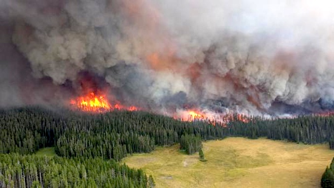
The Alum Fire blew up in size this past weekend. NPS photo.
Hot, dry conditions are feeding wildfires in Yellowstone National Park, some of which have grown by thousands of acres in just two days and were threatening a section of the Grand Loop Road on Monday.
The Alum Fire, which had been sparked by lightning to the west of Mud Volcano on August 14 had been burning across just 3 acres until Saturday, when it exploded across some 3,000 acres.
On Sunday, it spread to another 1,000 acres, park officials said Monday. The fire perimeter was within a mile of the Grand Loop Road south of Mud Volcano and park officials said there was the potential for temporary closures of the road between Canyon Village and Fishing Bridge Junction.
Overall, three major fires in the park have grown under the hot, dry, gusty conditions of the past four days.
"All three fires produced tall smoke columns visible for several miles in all directions. In addition, smoke from fires outside the park to the north and west in Montana and Idaho also contributed to occasionally hazy conditions at some locations at times during (Sunday)," a park release said.
* Alum Fire: Winds prompted two fingers of this fire to grow to the southeast on Sunday, after a long northeast run on Saturday. Mud Volcano, LeHardy Rapids, and several picnic areas and pullouts, as well as, some backcountry trails in the area are temporarily closed. Additional firefighters and engines arrived on Sunday and more were expected Monday and later in the week as fire mangers focus on protection of the road corridor, the boardwalk in Mud Volcano, and the nearby power line.
As a precaution, structure protection efforts were underway in Fishing Bridge, Lake Village, and Bridge Bay should the fire advance toward those areas in coming days. While area evacuations were not imminent, preparations were underway to assist residents and visitors in leaving the Fishing Bridge, Lake Village, and Bridge Bay area in the unlikely event that an evacuation is necessary in the coming days.
* Alder Fire: This fire at the south end of Yellowstone Lake was producing a smoke column in the afternoon and evening visible from all around the lake. Sunday’s hot, dry, windy conditions prompted it to grow to 2,000 acres. However, it is on a peninsula at the south end of Yellowstone Lake and is hemmed in by water on three sides and by a recently burned area to the south. Several backcountry campsites on The Promontory have been temporarily closed. This lightning-caused fire was discovered on August 14.
* Druid Fire: This fire burning in a steep heavily timbered area on Druid Peak is visible at times from along the Northeast Entrance road. It increased slightly from 60 to 75 acres on Sunday. This fire was started by lightning and was discovered on Friday, August 9.
* Other Fires: The Passage Fire was discovered Thursday at the south end of Yellowstone Lake. This lightning-caused fire remains quiet and is just half an acre in size. Some smoke was again seen on the Snake Fire, located three miles east of the South Entrance along the boundary with the Bridger-Teton National Forest. It remains estimated at 200 acres.
At times, some of the park fires are visible on the Mount Washburn Fire Lookout Web Cams. All roads leading into and through the park and the surrounding forest and all campgrounds, lodging, stores, and visitor services are open. Updated park road information is available 24-hours a day by calling 307-344-2117.


Comments
The photo brings back memories of the "big" Yellowstone fires in 1988. Hard to believe it's been 25 years since that situation.
Wow, from three acres to three thousand in two days. That's really scary.
A beauty of the finest kind...