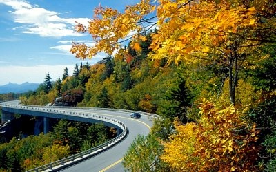
The post card view of the Linn Cove Viaduct (photos from top to bottom). Lowering the viaduct segments into place. No wonder the viaduct is a popular Nordic ski route. The unfinished end of the viaduct during construction. Bottom photo, the final viaduct segment being placed. Photos four and five at bottom are by Hugh Morton. Upper three photos by Randy Johnson.
After decades of controversy over the long-waited, much delayed completion of the Grandfather Mountain part of the Blue Ridge Parkway—it’s not surprising that it comes as a surprise to many that it will be 25 years ago on September 11th, 2012 when public vehicles first soared over the breathtaking Linn Cove Viaduct.
The viaduct was completed earlier, but it was a landmark event in 1987 when the ribbon was cut and motorists could experience the bridge from behind the wheel.
The Parkway was done—and today is one of the most memorable parts of a visit to the Boone area High Country of North Carolina. But one of the most iconic parts of “America’s Most Scenic Road” was just getting its start.
What had also begun was the legendary status of this bridge as an artful victory for the environment, a success story of sensitivity to nature. A naysayer or two has called that into question. But it doesn’t take much discussion with the landscape architects who worked their magic on Grandfather Mountain to realize that the viaduct was much more than a bridge. It was the dawning of an era when “environmental impact” really took hold.
Just the Facts
The basics of that claim are simple. It starts with the Parkway’s current location being a long-wrangled over compromise with Grandfather Mountain owner Hugh Morton who rejected the National Park Service’s proposal for a “high route.” Morton said slicing a road higher across the peaks, and burrowing a tunnel through pilot Ridge, would be “like taking a switchblade to the Mona Lisa.”
Morton prevailed and a “middle route” was chosen. But that location still retained a tricky passage of Linn Cove, a monumental, moss- and rhododendron-covered jumble of cliffs and boulders that defied road builders in the 1970s—much less decades earlier when the location controversy erupted and the road could have been completed if North Carolina had condemned the route.
The solution was the viaduct—a radical span built from the top down, from the starting point outward, over thin air, with sections glued together then torsioned with cables to form an undulating serpentine causeway just feet from trees, rocks, and thousands of feet of air.
Nobody better understood the challenge, or worked harder for a successful solution, than the landscape architects of the Blue Ridge Parkway.
In the Footsteps of Giants
From the start, landscape architects have shaped this road. The first and most formative of those was a true giant in the field, Parkway designer and first superintendent Stanley Abbott. He thought the parkway should “lie easily on the ground, blend harmoniously with the topography, and appear as if it had grown out of the soil."
If the Parkway isn’t enough of a monument, there’s a plaque to Abbott at the Peaks of Otter in Virginia where the lake is named for him. When the road went through, that lake was no doubt a fragile mountain bog that today would still be a bog.
Times have changed, and so has the meaning of “light on the land.” Greater sensitivity reigns now, thanks to the landscape architects and planners who followed, among them the Parkway’s viaduct-era planners Robert Allen “Bob” Hope, Robert Schreffler, and Gary Johnson.
Lemonade from Lemons
Gary Johnson, who started the viaduct project after joining the Parkway fresh out of college, attributes the idea of a “top down, segmental span” to the Federal Highway Administration engineers working with the Parkway planners. Johnson remembers regional geotechnical engineer Gary Klinedienst and Roy Crawford.
In an oral history recorded years ago, Bob Hope, the Parkway’s resident landscape architect during that time, under legendary Parkway Superintendent Gary Everhardt, described how the plan for the viaduct came about.
“We knew the rugged terrain at Linn Cove,” says Hope. “We had no idea how to get through there with a road. ... Finally after about three or four hikes around there with (what seemed like) everybody in the National Park Service,” he said, laughing, “we finally reached a location and agreed that the only way to get through here was just to bridge all these rock formations and not disturb the rocks.”
The Federal Highway Administration engineers said they'd have to get an outside consulting firm and Hope says, they just wanted to know: “Can it be done? Can you cantilever on a curvature like that without it tipping over?” And Figg & Muller, the eventual contractor, said, “'Yeah, it could be done." (For more on engineering giants Figg & Muller, read "The Wonder That Is The Linn Cove Viaduct.")
A Problem Waiting Decades for a Solution
All along, the Parkway’s route had Linn Cove in the way. Years of building had completed the road to the north and south, but after wrangling with Hugh Morton for a few decades, Bob Hope remembered, “We kind of designed and built (ourselves) into a problem with our back against the wall. We had to do something to get on through.”
Hope remembers one bridge engineer on the project who may have made all the difference.
“Rex Cocroft,” said Hope. “He's probably the one who sold federal highway on that design scheme. The precast segments placed in progressive placement.”
Hope remembered, “There's a story about Rex and some of the engineers from Federal Highway. We would meet at Grandfather Mountain and talk and look at preliminary plans. I don't know how long this process had gone on. But the outcome usually was, why, they would go back to Arlington and study it some more.”
“Finally,” Hope said, “we met down there and they decided they'd go back and study it
some more. So the landscape architects went home and Federal Highway stayed on another night. Said Hope, ‘Well, you know we've done this two or three times, there's no need for us to go back to Arlington and study it some more.' They decided they would stay there until they worked it out.”
“That night,” says Hope, “they were sitting around talking. Rex had a topo map of the area and he started circling in red the points where there were suitable footings. So he'd circle this one in red. And here's another over here. Finally they decided, 'Well, there, that was the design.' They just connected the red dots ... and there's your bridge.”
Imagine, just a few years after the National Environmental Protection Act—called the modern equivalent of a global “Environmental Magna Carta”—the already “light on the land” philosophy of the Parkway had stepped into a new era of environmental protection with the Linn Cove Viaduct.
This road would not be gouged through a piece “land.” It would float over a sensitive environment—elevated above single spots where a road could be supported.
Gary Johnson Among His Mentors
Johnson was among the group of National Park Service and Federal Highway Administration technical staff overseeing the planning and construction of the “Missing Link.”
Johnson was heading into regional planning until a Vietnam War stint in the US Air Force redirected him to landscape architecture. After earning his degree at Virginia Tech, he found himself at National Park Service’s Denver Service Center in the late 1970s. He was transferred to the Blue Ridge Parkway from 1976 to 1979, and after planning the setting for the Folk Art Center, he became the National Park Service’s primary project inspector with Federal Highway Administration engineers on Grandfather Mountain. He prepared construction drawings for the Linn Cove Viaduct abutment treatments, site plans, and several overlooks.
Johnson was one of five people working on the bridge pictured in a 1979 Denver Service Center newsletter article standing on the route of the future viaduct “in an area undisturbed by roads or even trails”—much as Stanley Abbott had done all along the route of the Parkway. One participant was asked what he thought of the bushwhack hike. “That was two hikes for me,” he said, “my first and my last through that part of the country, though it was beautiful.”
Johnson remembers leading a tour of the viaduct site for one of the firms intending to bid on the design of the project.
It was during the bitter winter of 1977 and “they needed to walk the site of the seven viaduct support piers. It was just bloody cold,” he says. “We drove near the site, but there had been a major snow and ice storm. We almost froze to death. I had to dig down through the snow just to find the stakes for the piers.”
As the viaduct plan was completed by Figg & Muller Engineering and construction started, Johnson became “the enforcer” for efforts to make the new road “lay lightly on the land.”
Flagging a Route to the Future
It was Johnson’s job to hand pick and flag the trees that were permitted to be cut for construction. After construction started, he was monitoring compliance with the rules when he came back to find a mass of dirt and rocks piled against a major old tree. “I really let’em have it,” he says. “I told them to build tree wells in those situations and to really walk a lot more softly.”
About a week later Johnson was called back. The contractor refused to cut an unflagged tree and Johnson had to OK it. “I went out there and this tree was 6-feet tall and one-inch in diameter,” he says with a laugh. “The thought crossed my mind that these guys were messing with me, but they’d gotten the message. I needed to make these kind of decisions and we wanted the contractor to know we were serious.”
“Our goal for this bridge,” Johnson says, “was to have it look like it had been there for a century—to look like it had almost grown out of the mountain.”
The stunning fact is that today’s thorough environmental impact statements were in their infancy. Hope and Johnson had written the EIS for the viaduct—30 pages. “It would be a book today,” he says.
That might get people nodding who dislike government regulation—but why shouldn’t an assessment of environmental impact on this site, on this mountain, be that thorough? “Today we’d have botanists and biologists all over out there,” Johnson says. “Truth be told, many of the species on that mountainside weren’t even inventoried. Nevertheless, the National Environmental Protection Act had set some standards. Environmental sensitivity was at the front of our minds.”
Johnson remembers other examples of concern for the environment. When the sites for the viaduct supports needed to be checked, core sampling drills were helicoptered onto the spot where they were needed.
The expense of the “Missing Link” also escalated as new bridges were needed to lessen impact. As the road was planned lower on the mountain, more and bigger drainages had to be crossed and more pronounced ridges required more elaborate curves and turns—the single reason why the 45 mph speed limit of the Parkway had to drop to 35 mph around Grandfather Mountain.
That meant more bridges, but even more were added when sensitive areas had to be crossed. Johnson remembers an “unmerciful” lobbying session with a Federal Highway engineer who was adamant that his “boss said no more bridges—and now you want two more bridges! He’s going to be mad as hell!”
Johnson and the Parkway got their way. Many places on that section were just not “suitable to conventional cut and fill or culvert.” So Johnson was able to put a very low bridge above a boulder field with a complex natural drainage system.
Another victory of technology over destruction came at “The Great Wall of China,” that massive retaining wall just across the Parkway from the Rough Ridge Parking Area. “That was all new technology that held the road away from the mountain, reducing the road cut above and containing the fill below.”
Timing is Everything
“You know,” he continues, “it’s likely that the years of controversy with Hugh Morton permitted the right solution to emerge. I personally believe that the viaduct was the perfect solution for that landscape. If the road had been built when originally planned, it wouldn’t be what it is today.”
Johnson came back to the Blue Ridge Parkway from 1994 to his retirement in 2011. During those years, Johnson “literally wrote the book” about preservation of the Parkway’s scenic views. His Guidebook for the Blue Ridge Parkway Scenery Conservation System is the Parkway’s handbook for protecting scenic vistas.
Johnson received the Appleman-Judd-Lewis Award for excellence in cultural resource management on March 17, 2011 from National Park Service Director Jonathan Jarvis. Presenting the award, Jarvis said, “Preservation is about deciding what's important, figuring out how to protect it, and passing along an appreciation to others. Recipients of this award have excelled in all of these aspects.”
Looking back, Johnson says, “we never realized how iconic this part of the Parkway would become, but it’s hard not to be proud to have helped design and build it. I’m convinced this part of the Parkway can trace its heritage all the way back to Stanley Abbott.”
This End Was a Beginning
Of course, the road opened to wide acclaim on September 11th, 1987. By the time it did, hikers were wandering the mountain side on the Tanawha Trail, seeing even more spectacular sights than the vistas visible from the viaduct.
The Tanawha Trail almost didn’t happen. Bob Hope remembers, “When the parkway was being funded, we knew we wanted a foot trail to connect the overlooks, but there was no project money for the trail. So the superintendent (Gary Everhardt), decided to take it on as a project. He convinced the Federal Highway that the foot trail was an integral part of the parkway. And so it was funded.”
Today, the Tanawha Trail explores the sunny side of Grandfather now known for world-class biodiversity befitting what the mountain subsequently became—an International Biosphere Reserve. On the trail’s climb from Linn Cove, it gently crosses a spectacular boulder garden of rare plants, one of the mountain’s many distinct ecosystems, much like the area successfully spanned by Johnson’s bridge. (Download a map of the trail on this Parkway page, then click "Tanawha Trail" pdf.)
Ironically, this pristine place still exists—exactly where the “high route” of the Parkway might have eradicated it—had construction not taken a long pause while the technology needed for the viaduct dawned with the computer age.
Johnson says, “I was there when the arguments and negotiations with Hugh Morton were fresh in people’s mind. For years the National Park Service had been hoping the state would just buy Grandfather Mountain,” Johnson says. “Sometimes things just happen when they’re ready. This part of the Parkway almost seems predestined to have turned out for the best.”
This fall when you head out on the Parkway near Asheville, it's easy to drive the Parkway north of Boone and pause near the Virginia line at Cumberland Knob, where the Parkway started 77 years ago. There’s a monument there to notice. It honors the Parkway’s landscape architects—the folks whose toil and troubles have redeemed the promise of this iconic park.
Randy Johnson trudged the Parkway route with Bob Hope and Hugh Morton as the mountain’s trail manager. He's the author of Hiking the Blue Ridge Parkway and other books.
Story Categories:
A copy of National Parks Traveler's financial statements may be obtained by sending a stamped, self-addressed envelope to: National Parks Traveler, P.O. Box 980452, Park City, Utah 84098. National Parks Traveler was formed in the state of Utah for the purpose of informing and educating about national parks and protected areas.
Residents of the following states may obtain a copy of our financial and additional information as stated below:
- Florida: A COPY OF THE OFFICIAL REGISTRATION AND FINANCIAL INFORMATION FOR NATIONAL PARKS TRAVELER, (REGISTRATION NO. CH 51659), MAY BE OBTAINED FROM THE DIVISION OF CONSUMER SERVICES BY CALLING 800-435-7352 OR VISITING THEIR WEBSITE. REGISTRATION DOES NOT IMPLY ENDORSEMENT, APPROVAL, OR RECOMMENDATION BY THE STATE.
- Georgia: A full and fair description of the programs and financial statement summary of National Parks Traveler is available upon request at the office and phone number indicated above.
- Maryland: Documents and information submitted under the Maryland Solicitations Act are also available, for the cost of postage and copies, from the Secretary of State, State House, Annapolis, MD 21401 (410-974-5534).
- North Carolina: Financial information about this organization and a copy of its license are available from the State Solicitation Licensing Branch at 888-830-4989 or 919-807-2214. The license is not an endorsement by the State.
- Pennsylvania: The official registration and financial information of National Parks Traveler may be obtained from the Pennsylvania Department of State by calling 800-732-0999. Registration does not imply endorsement.
- Virginia: Financial statements are available from the Virginia Department of Agriculture and Consumer Services, 102 Governor Street, Richmond, Virginia 23219.
- Washington: National Parks Traveler is registered with Washington State’s Charities Program as required by law and additional information is available by calling 800-332-4483 or visiting www.sos.wa.gov/charities, or on file at Charities Division, Office of the Secretary of State, State of Washington, Olympia, WA 98504.
Comments
Superb article - thanks for writing it. The parkway is one of our premier destinations this fall, and your article will help us enjoy the experience a whole lot more.
I never made it to Blue Ridge when I did my 6 month road trip around the USA in 2004 and have regretted it ever since. It seems absolutely amazing!
Randy Johnson is posting this comment for John Corven because it would not load for him—
[color=#0000FF]Very nice article with regard to the vision of the project, but lacking with regard to how it became a reality. That reality was only achieved because of the genius of[/color] Jean Muller, the father of precast segmental construction. Mr. Muller was the direct student of Eugene Freyssinet, the father of prestressed concrete. These were giants in the field of bridge construction and shaped the way modern concrete bridges are built. Mr. Figg was the visionary that saw the need for these methods in America. And hence, Figg and Muller Engineers, the engineer for the bridge. The contractor was Jasper Construction Company. I started my bridge design career working for Figg and Muller on site at the Linn Cove Viaduct - an amazing experience - and worked with Mr. Figg and Mr. Muller for many years. On a lighter side, neither Mr. Figg or Mr. Muller would have used the word "Yeah". Mr. Figg would have responded with a warm but professional southern "Yes Sir". Mr. Muller's response would have no doubt have been "Mais, bien sur".
Regards,
John Corven
John A. Corven, P.E.
President and Chief Bridge Engineer
Corven Engineering, Inc.
John, thanks very much. I agree—this article does not delve into the part of the story you describe. I wanted to tell a different part of the story with this piece—and in no way intended to deny credit where it is due. I have in fact written about the subject you suggest in another article on the Traveler.
Please read, "The Wonder that is the Linn Cove Viaduct" for more.
In addition, you might like a two part series on Gary Everhardt, Parkway superintendent at the time, that also delves into the viaduct's story. Thanks for your note.