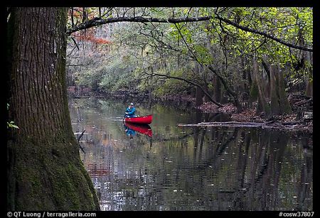
Paddling the Cedar Creek Canoe Trail is a great way to experience the beauty and tranquility of Congaree's remarkable old-growth forest. Photo by QT Luong, terragalleria, used with permission.
What can you say about a place that’s an International Biosphere Reserve, a Globally Important Bird Area, a National Natural Landmark, a federally designated Wilderness Area, and an Outstanding National Resource Waters designee? Well, for one thing, you can say “Go visit it!”
Located smack-dab in the middle of South Carolina, just a half-hour’s drive from the capital city of Columbia, Congaree National Park preserves North America’s largest remaining old-growth bottomland forest. Although this nearly 27,000-acre park has around 600 acres of piney uplands, including about 200 acres of valuable longleaf pine habitat, its ecological centerpiece is a virtually pristine 12,000-acre tract of floodplain forest. The bottomlands of the Congaree Swamp, which look pretty much the way they did when Native Americans hunted there, are mantled with bald cypress, tupelo, laurel oak, sweet gum, water hickory, loblolly pine, and other trees inclined to grow to unusually large size. Thanks to periodic flooding (averaging 3 significant floods a year, with a major one about every three years) and the deep fertility of the muck, peat, and related alluvial soils, the Congaree Swamp has one of the tallest temperate forest canopies in the world. There are at least 20 state or national champion trees and lots of others nearly as big. Small wonder that some admirers were inspired to dub this place “Redwoods East.”
It’s unfortunate – at least for the park’s image -- that the floodplain of the Congaree River acquired the name Congaree Swamp in historic times. Technically, this river bottom environment is not a swamp at all because it is not permanently covered with water. Like other low-lying natural areas situated near rivers, the Congaree floodplain is periodically covered by flood waters throughout the year, but is (except for the sloughs and creeks) soggy or dry the rest of the time.
Few places this size can match Congaree for ecological diversity. People used to seeing managed monoculture forests with even-aged stands of trees are blown away when they see the variety of plant and animal life in this place. In addition to 75 or so species of trees, the park has at least 195 species of birds, 60 species of fish, more than 65 species of butterflies, hundreds of insect species, and over75 species of reptiles and amphibians.
Alligators can’t nest in the park because of the frequent flooding, but snakes are fairly common. Although most are harmless species, four are venomous (copperhead, canebrake rattlesnake, cottonmouth, and coral snake [rare]). Venomous snakes avoid people, and visitors exercising due caution are exceedingly unlikely to be harmed. The park’s only recorded incidence of snakebite involved a poacher who carelessly handled a copperhead.
Old-growth forests create many more niches for plant and animal species than cutover forests do. The amazing biodiversity of this particular old-growth forest can be attributed to the park’s sanctuary status, variations in topography and the water table, location along a river corridor, and the presence of streams, sloughs, guts, oxbow lakes, ponds, temporary pools, edges (ecotones), snags, and other natural features.
Congaree actually has four different kinds of forests, including a mixed pine and upland forest found on the higher ground of the bluffs and three kinds of wetlands -- mixed bottomland hardwoods, swamp tupelo seepage, and cypress-water tupelo swamp. The latter is highly distinctive because the bald cypress and tupelo grow in the standing or slowly flowing water of sloughs, guts, and ponds.
Because of the high water table and related soil and moisture differences, a one-foot difference in floodplain elevation can produce as much plant species variability as a thousand-foot difference in the mountains. Not surprisingly, nearly two dozen distinctive ecosystems have evolved within the four principal kinds of forest
If Congaree’s old-growth forest, towering trees, and great ecological diversity inspire awe, it remains that the park has received little publicity since it was established in 1976 (as Congaree Swamp National Monument) following a grassroots campaign that barely managed to prevent the old-growth forest from being logged out of existence. Many of the more than 120,000 people who visit Congaree each year arrive not quite knowing what to expect, but go away realizing that they have experienced something unique and very special.
Publicity attending the park’s redesignation from National Monument to National Park in 2003 yielded a spike in attendance and is expected to boost annual attendance substantially in years to come. The park is underutilized and can easily accommodate far more visitors than it attracts.
The bottomland forest of the Congaree Swamp, the last great forest of its kind on the continent, has an earthy, primeval quality that is difficult to capture in words. Visiting Congaree is, as some have said, “like seeing a living dinosaur.”
If you haven’t seen Congaree’s tranquil wilderness for yourself yet, you’ll want to seize some early opportunity to add this park to your life list. Here are some things that will help you plan your visit.
If you've got enough lead time, phone the park (803-776-4396) and ask them to send you a visitor packet that includes a brochure and map, information about specific activities and events of interest to you, and the current issue of the park newspaper, Boardwalk Talk. Be sure to ask about any reservations that you may need to make for the programs or activities that interest you. Many visitor information publications you'll want to have can be viewed at this site or obtained at the visitor center when you arrive.
The park map at this site will orient you to where things are. Note that nearly all of the park’s infrastructure/amenity elements, including the entrance, visitor center, and all of the maintained trails have been confined to the northwestern end of the park in order to preserve the wilderness quality of the place. Over half of the park’s area (15,000 acres) is federally designated wilderness, and most of the rest is roadless backcountry with a wilderness feel to it.
Nearly the entire park is managed to a wilderness standard, with minimum development and a strong emphasis on ecosystem preservation, scientific research, and low-impact recreation. Congaree National Park is a component of the South Atlantic Coastal Plain Biosphere Reserve. The park’s Old-Growth Bottomland Forest Research & Education Center (ensconced in the old ranger station/visitor center) is well on its way to becoming one of the nation’s foremost old-growth forest research facilities.
The timing of your visit matters. Congaree National Park is open 24 hours a day, 7 days a week, but seasonal considerations are important. Comfort-wise, you’ll want to visit this park in the spring or fall if you can, because that’s when the weather is most amenable to outdoor activities and there are fewer insect and spider issues. Of course, if you are particularly interested in the birding, you’ll probably want to plan your visit around the breeding season and the spring and fall migration seasons.
Memorial Day weekend and Thanksgiving are usually the park’s busiest times. The spring in general is popular with visitors, since the weather is mild and there are few insects and spiders. Fall also brings pleasant, typically dry weather. Thanksgiving weekend and the Christmas-New Years holiday season are both times when lots of local residents bring visiting friends and relatives to the park for sightseeing. The slowest months are June through September (hot and muggy, with more bothersome insects and spiders) and January (too chilly).
Bring along the food and drink you’ll need. Congaree is primarily a day-tripper’s park, so don’t expect to find the amenities typical of destination parks. There is no on-site lodging, nor can you buy food or gasoline on the premises. The nearest place to buy groceries, fast food, and fuel is the small town of Gadsden, about five miles away. A full range of higher-order amenities can be found in Columbia about 20 miles distant.
Although the park does not yet have a developed campground, there are primitive camping and backcountry options. All campers, including backpackers, are required to obtain a free camping permit and a list of regulations at the Harry Hampton Visitor Center prior to camping. The park has two primitive campgrounds, both of which are open all year. The After Hours Campground (7 sites, limit 8 campers each) has porta-johns, fire rings with grills, and picnic tables. The Bluff Campsite, the designated group camping area (3 sites, up to 40 campers each), is equipped with fire rings and picnic tables. Backcountry camping in association with hiking or paddling is available all year.
This is definitely a park you can visit on the cheap. There is no entrance charge, the ranger-led tours are free, and you don’t have to pay for your camping permit.
You can bring your dog, but make sure it remains leashed and keep it off the boardwalks. Dogs are allowed on all of the park’s trails except the Boardwalk Loop.
Ranger programs and other organized activities (such as Owl Prowls, Tree Treks, Big Tree Hikes, Nature Discovery Walks, and annual memorial walks) are offered throughout the year, with seasonal variations. “There’s always something interesting going on at Congaree!” For general information about ranger walks and talks, visit this site. For additional information about special events and other activities, visit this site and check the specific date(s) of your planned visit. It’s good idea to phone the park for updated information, especially when the scheduled activities are weather-sensitive.
Ranger-led nature walks or guided hikes can be arranged for school children and other groups by appointment. During a typical school year, more than 600 groups of school children are bused to the park for ranger-led nature walks.
Don’t forget to make reservations! Some of the programs and organized activities you may want to participate in require reservations, and some of those reservations may have to be made well in advance. Some of the guided hikes require reservations. The popular Owl Prowl evening programs require reservations two weeks in advance and fill up quickly. The ranger-led Cedar Creek paddling excursions using park-furnished canoes also require advance reservations and have restrictions you should know about. Other examples can be cited. The central idea here is that you can reap important dividends and spare yourself a lot of grief by doing a little homework and planning ahead.
WHEN YOU GET THERE
* You don’t want to miss the Harry Hampton Visitor Center, which is open from 8:30 a.m. until 5:00 p.m. every day (except Christmas), and until 7:00 p.m. on Fridays, Saturdays and Sundays during Daylight Savings Time. A 1.5-mile paved access road leads from the park entrance on Old Bluff Road to the 12,000-square foot visitor center, which is named in honor of the local newspaper writer who first championed the idea of preserving the Congaree Swamp’s old-growth forest. Among the many features of this award-winning structure (new in 2001) are excellent office, meeting, and research facilities for the staff, museum-quality exhibits, a wall mural, a theater, and a bookstore.
The visitor center’s exhibit hall is dominated by “Big Tree,” a synthetic bald cypress that flares 14 feet wide at its hollow base and soars majestically through the ceiling. (It’s so realistic that some visitors think it’s a living tree.) The wall mural, which was painted by renowned muralist Blue Sky, depicts a floodplain forest scene. The floor exhibits include a giant fallen tree and several exhibit islands designed to depict themes such as species diversity, ecosystem structure and function, hydrology, and historic uses of the riverbottom forest.
* Stroll the Boardwalk Loop. There are about 25 miles of trails in the park. The trail that gets the most use is the 2.4-mile Boardwalk Loop trail that extends from the bluff through the forest to Weston Lake (an oxbow lake formed by an abandoned river channel) and then loops back. One portion of the trail is a 0.7-mile elevated boardwalk that is perched as much as 6 feet above the forest floor. (One nice feature of the elevated boardwalk walk is an abundance of kids-eye views to be had on and underneath the railings.) The rest of the boardwalk (the “Low Boardwalk”) rests on the forest floor and is submerged during floods. A boardwalk that begins at the rear of the visitor center connects to the Boardwalk Loop trail. Most people take about 90 minutes to complete the loop. The entire boardwalk system is wheelchair accessible. Before you set out on the Boardwalk Loop, be sure to obtain a free self-guiding brochure at the Harry Hampton Visitor Center. Wooden numbers on the boardwalk rails coincide with sections of the brochure that point out features of special interest and explain some of the history and ecology of the park.
The Low Boardwalk passes through a primeval bald cypress and water tupelo forest. Cypress "knees" protrude from the forest floor creating a mystical aura. The knees, part of the tree's root system, are thought to help aerate the roots and anchor them in the wet soil.
* Take a walk on the Sims Trail/service road. The gravel road that once led to the Cedar Creek Hunt Club's clubhouse (long since demolished), and which once served as the park’s principal entryway, now doubles as a service road and a nature walk trail (formal name Sims Trail) leading from the bluff to Cedar Creek and Wise Lake. You’ll cross this rough gravel road while traversing the low boardwalk section of the Boardwalk Loop trail near Weston Lake. A stroll along the service road (water conditions permitting) offers a fine supplement to the boardwalk experience and is not as demanding as the dirt trail options. Like the boardwalk, Sims Trail is very kid-friendly. Puddles on the Sims Trail often have tadpoles in them, and the water attracts butterflies, dragonflies, and other interesting creatures.
* Hike the primitive trails. As the park map shows, there are five primitive (dirt) trails, all with colored markers that make them easy to follow. They are the Bluff Trail (1.6 miles), the Weston Lake Loop Trail (4.6 miles), the Oakridge Trail (7.5 miles), the King Snake Trail (11.1 miles), and the River Trail (10.4 miles). If your time is very limited, one option is to do the Bluff Trail (~25 minutes) -- just remember that this trail passes through a young plantation forest of loblolly pines and affords no opportunities to get up close and personal with the giants of the river bottom forest. The Weston Lake Loop Trail (2.5 hours), which is conveniently accessible from either the low boardwalk or the elevated boardwalk, is a much preferred “dirt trail quickie” because it traverses old-growth forest, following a cypress-tupelo slough and the north bank of Cedar Creek. You’ll see some enormous trees, and if you’re lucky, you’ll see river otters in the creek.
If you have an entire morning or afternoon for primitive hiking, the longer trails are well worth the extra investment of time and effort. The 7.5-mile Oakridge Trail (~4 hours), which passes through a rich stretch of old-growth forest (lots of large oaks) and crosses a number of "guts" or small creeks, is a good choice for those in search of a moderate hike. The 11.1-mile King Snake Trail (~5.5 hours) explores a remote part of Congaree, following a long-disused logging road part of the way, passing a huge cypress-tupelo slough, and affording opportunities to see some very large trees as well as lots of birds and other wildlife. The 10.4-mile River Trail (~5 hours) takes you to the Congaree River by way of an area that was logged prior to the park's establishment and therefore gives you a good look at a forest in successional stages.
The riverbottom forest is not a jungle! In fact, except where flooding has piled up debris, it is easy to walk around on the forest floor. That’s because it’s largely clear of heavy undergrowth. The closed canopy of the tall trees creates so much shade that sunlight-loving shrubs and grasses cannot get established on the forest floor. The densest growth of vegetation is generally found on the margins of the larger water bodies and in areas where the canopy has been opened by severe storms, fires (rare in the floodplain), or human activities such as road building.
This is a true wilderness, so you’ll need to obey the park rules and the dictates of common sense. Hikers who stray from the marked trails can easily become confused and lost. People who can’t identify poison ivy (hairy vines and “leaves of three, let it be”) are likely to regret it. Open fires are prohibited (camp stoves are OK), and backpackers must move at least 200 feet away from the trails (500 feet from buildings and boardwalks) before pitching their tents. If you plan to hike the primitive trails, and certainly if you plan to camp in the backcountry, pay attention to the weather forecast and check with the park for current information about trail conditions on the floodplain. Flooding, storm debris, and other factors may render the riverbottom dirt trails (or segments thereof) impassable or very messy to use. Remember that floodwaters take days to recede after major flooding, and the dirt trails can take a long time to dry out.
* Take a “big tree hike”. You need to go off-trail to see many of Congaree’s most impressive trees, including nearly all of the state and national champion trees. Since you can easily get lost in the forest, it pays to err on the cautious side. Know what you’re doing! And if you can’t navigate confidently off-trail, make sure there’s somebody in your group who does. One option many people prefer is to take a guided hike. This generally means either a ranger-led Big Tree Hike or one of the big tree hikes periodically offered by Friends of Congaree Swamp (the park's principal partner) or other NGOs. The ranger-led hikes use GPS technology to locate champion trees and other trees high in “wow factor.” The guided hikes are for small groups only and reservations are required. Though not particularly strenuous, the Big Tree Hikes are lengthy (on the order of five or six miles) and definitely not for small children.
* Birders, don’t forget your binoculars! Many visitors (at least seasonally) are amateur ornithologists or birdwatchers attracted by the park’s great diversity of bird species, some of which are scarce or rare. (The park was designated a Globally Important Bird Area in 2001.)The riverbottom forest provides valuable sanctuary and breeding areas for a variety of comparatively rare birds, including neotropical species (such as the prothonotary warbler and the swallow-tailed kite) that winter in Mexico, Central America, the Caribbean, or South America. Although the park has one of the nation’s densest and most diverse concentrations of woodpeckers (eight species), there aren’t any ivory-billed woodpeckers there anymore – at least none that we know of.
* Take a Never-To-Be-Forgotten Owl Prowl. The extremely popular Owl Prowl ranger walk series takes limited numbers of visitors on Friday evening walks in the park throughout the year. The programs, which last two hours and involve a 2.5-mile walk, are usually presented on Friday evenings just before dusk (weather permitting). Bring flashlights with red filters. Expect to hear barred howls hooting. You might see foxfire and flying squirrels too. Owl prowls are offered free of charge, but you’ll need to make reservations two weeks in advance. Tell Fran I sent you.
“Fran is the man.” During 1980-2003 alone, over 50,000 students took tours led by veteran ranger Fran Rametta. Fran, who still works in the park, is renowned for his naturalist skills and unbounded enthusiasm, his popular “owl prowls,” and his propensity to hoot like a barred owl. Fran even has an owl hoot on his telephone answering machine.
* Paddle the Cedar Creek Canoe Trail. Traveling by canoe or kayak is a great way for you to enjoy this primeval wilderness while floating past some of the biggest trees you’ll ever see. Because you travel slowly and quietly, you’re likely to encounter more wildlife such as turtles, white-tailed deer, river otters, snakes, raccoons, and wild pigs. You can paddle the American Rivers Blue Trail-designated Congaree River (also a National recreational Trail nominee), but there is no vehicle access to the river within the park. Paddlers find it easier to use the marked canoe trail on Cedar Creek, a stream that traverses the floodplain from the bluff to the river. It’s possible to canoe or kayak Cedar Creek all the way across the park to the river, and thence an additional 13 miles downriver to the Highway 601 landing. However, most paddlers using the Cedar Creek Canoe Trail take the half-day trip (about four hours) that begins at Bannister’s Bridge on Old Bluff Road and ends at Cedar Creek Landing on South Cedar Creek Road.
The park offers free guided canoe trips (by reservation only) each Saturday and Sunday, weather permitting, throughout the year. Although the park provides some canoes (at no charge) for this purpose, the guided trips are a BYOC (Bring Your Own Canoe) experience for many participants. Canoes and kayaks can be rented from outfitters in Columbia.
It’s always a good idea to call the Visitor Center and inquire about paddling conditions before you go to the park. The recreational quality of paddling excursions on Cedar Creek is heavily influenced by the level of the water and the amount and type of debris in the creek. Portions of the canoe trail are difficult or impractical to use during floods (which make navigation difficult), after severe storms (which drop trees and branches into or across the creek), or when the water is unusually low (exposing too many downed trees or other obstacles to go around or haul over). Canoe trail maintenance is a time-consuming and difficult task, so bothersome obstacles may remain uncleared for months at a time.
The park offers this additional advice to paddlers:
Be aware of potential hazards such as poison ivy, mosquitoes, wasps, spiders, and snakes which inhabit the park in ample numbers. Bring insect repellent, a first-aid kit, life jackets, a compass, a map (available at the visitor center or on this website), and extra food and water. Remember to wear comfortable clothing, and be prepared to get muddy. A final caution: although marked, the Cedar Creek canoe trail may be hard to follow in places. When in doubt, keep a keen watch for the diamond-shaped markers. However, because of Wilderness designation regulations, canoe trail markers are limited.
* You can bring your fishing gear, but you may not want to. Although the Congaree River can be very productive, and harbors some very big striped bass (rockfish) and catfish, the park’s stream and lake waters offer fishing that is mediocre at best. Wise Lake has produced some very nice largemouth bass and panfish, and some fishermen have had success with panfish in Cedar Creek. People toting fishing gear should use the service road, not the boardwalks, to access Wise Lake and nearby Cedar Creek. Remember that you must have a South Carolina state fishing license, and that fishing is not permitted in Weston Lake (located at the end of the elevated boardwalk).
* You can bring your bike, but you may not want to do that either. There are no designated bike trails at Congaree National Park. The only place in the park that you are welcome to ride your bike is on the 1.5-mile paved entrance road that leads from Old Bluff Road to the visitor center. Bike riding on Old Bluff Road, a two-lane paved highway with no shoulders (but lots of speeding cars), can be just plain dangerous and is generally not a good idea.
RESOURCES
The Conagree National Park website has detailed information. For park maps, visit this site.
FRIENDS ORGANIZATION
The mission of the Friends of the Congaree Swamp has four main components: (1) Increasing recognition, public awareness, and appreciation of Congaree National Park as a resource of local, state, national, and international significance; (2) Protecting and restoring the ecological systems and natural beauty of the park while seeking to maintain compatible land uses outside the park; (3) Enhancing educational, interpretive, and research opportunities relating to the natural heritage and historical heritage of the park and its environs; and (4) Supporting the park through advocacy, volunteer service, and fundraising.
Story Categories:
A copy of National Parks Traveler's financial statements may be obtained by sending a stamped, self-addressed envelope to: National Parks Traveler, P.O. Box 980452, Park City, Utah 84098. National Parks Traveler was formed in the state of Utah for the purpose of informing and educating about national parks and protected areas.
Residents of the following states may obtain a copy of our financial and additional information as stated below:
- Florida: A COPY OF THE OFFICIAL REGISTRATION AND FINANCIAL INFORMATION FOR NATIONAL PARKS TRAVELER, (REGISTRATION NO. CH 51659), MAY BE OBTAINED FROM THE DIVISION OF CONSUMER SERVICES BY CALLING 800-435-7352 OR VISITING THEIR WEBSITE. REGISTRATION DOES NOT IMPLY ENDORSEMENT, APPROVAL, OR RECOMMENDATION BY THE STATE.
- Georgia: A full and fair description of the programs and financial statement summary of National Parks Traveler is available upon request at the office and phone number indicated above.
- Maryland: Documents and information submitted under the Maryland Solicitations Act are also available, for the cost of postage and copies, from the Secretary of State, State House, Annapolis, MD 21401 (410-974-5534).
- North Carolina: Financial information about this organization and a copy of its license are available from the State Solicitation Licensing Branch at 888-830-4989 or 919-807-2214. The license is not an endorsement by the State.
- Pennsylvania: The official registration and financial information of National Parks Traveler may be obtained from the Pennsylvania Department of State by calling 800-732-0999. Registration does not imply endorsement.
- Virginia: Financial statements are available from the Virginia Department of Agriculture and Consumer Services, 102 Governor Street, Richmond, Virginia 23219.
- Washington: National Parks Traveler is registered with Washington State’s Charities Program as required by law and additional information is available by calling 800-332-4483 or visiting www.sos.wa.gov/charities, or on file at Charities Division, Office of the Secretary of State, State of Washington, Olympia, WA 98504.
INN Member

The easiest way to explore RV-friendly National Park campgrounds.

Here’s the definitive guide to National Park System campgrounds where RVers can park their rigs.
Our app is packed with RVing- specific details on more than 250 campgrounds in more than 70 national parks.
You’ll also find stories about RVing in the parks, tips helpful if you’ve just recently become an RVer, and useful planning suggestions.

Comments
The 2.5 mile boardwalk is a great hike, but be warned there are no bathrooms on it and you can't just "duck off into the woods". If you're reading through the excellent nature guide pamphlet, stopping to take pictures, and watching the wildlife it can easily take 2 hours or more. For some of us older folks that means the last 1/4 of the trail gets covered rather quickly in a mad dash back to the Visitor's Center!! So be prepared! It may pay to make it a double loop, slow through one half, quick through the rest back to the Visitor Center. Then reverse your course and walk the loop the other way. Walking through it the other direction also let's you see things you missed the first time.
I was surprised to read dogs "are allowed on all of the park’s trails...", since this activity is forbidden in most NPS units. Was this a compromise to get this park established?
Provisions for pet access apparently played no role in the establishment of Congaree Swamp National Monument in 1976 or its redesignation as Congaree National Park in 2003. It's important to note that pets are not allowed on the boardwalks, except to access the first set of stairs leading to dirt trails. Pets may be taken on all of the other park trails provided that they are leashed (maximum length six feet) or physically confined. Park officials want you to cleanup after your pets. Towards this end, biodegradable bags are conveniently located at the Primitive Campground and at the beginning of the elevated boardwalk section of the Boardwalk Loop Trail.
I brought a Carolina Mountain Club group to Congaree this past weekend.
We were very lucky to have Bob come and speak to the group on the history of the park.
Thank you, Bob
A great park and very different from the Southern Appalachian mountains.
Danny
Just visited there on a swing through the Carolinas, did some hiking on two different days. Probably a bit early, but it was nice weather and no bugs. Charlie Daniels' "Wooly Swamp" kept going through my head :wink:
But here's a question: is the paddle 'trail' really open? It looks like there's a lot of trees down across the creek ...
Downed trees and other obstacles don't close the canoe trail, Barky, they just make for frequent portages/hauls and more work (meaning less fun). What can make the canoe trail nearly impassible is low water following prolonged periods with little or no rain. That's the crux of it. Maintenance crews can clear out debris from time to time, but they can't make rain. BTW, I agree that the weather's been exceptionally nice lately. And I didn't encounter a single mosquito on the Boardwalk Loop this past Friday afternoon.
I am watching the video on PBS. I have riden through Columbia hundreds of times but have missed this jewel. The Edisto Gardens has been one of my favorite spots for visiting the big trees. I plan to make congaree my next stop in passing through the capital.
This is an excellent park. We've hiked twice, and canoed once. I highly recommend a strong bug spray as the SC summer heat/ humidity prove to draw every mosquito for miles around. If you're physically able, take one of the loops that adventure further into the forest ... away from the boarkwalk. An easy pace can bring you back to the Visitor's Center in a matter of hours. And it's only a short drive from Columbia, SC and easily accessible from all corners of SC as well as southern NC. And, hey, it's free! You don't have to pay admission for the canoe trip, either ... but book well in advance! The canoe trip is hard to come by, and well worth the effort. Enjoy!
Thanks for posting this Bob! It is unfortunate that so many people do not know about the park, especially in Columbia.
I am no longer surprised, just saddened, when I meet people who have lived in the Columbia area for many years and still don't know that Congaree National Park is just a half-hour drive from their home. That said, the park continues to be a major regional attraction, logging more than 120,000 visitors in each of the past three years.
This park is really great for die-hard naturalists.