Thanks to such roads as the 48-mile (77-kilometer) Trail Ridge Road through Rocky Mountain National Park in Colorado, 50-mile (80-kilometer) Going-to-the-Sun Road through Glacier National Park in Montana, 32.5-mile (52.3-kilometer) Generals Highway through Sequoia and Kings Canyon National Parks in California, 469-mile (755-kilometer) Blue Ridge Parkway through Virginia and North Carolina, and 105-mile (169-kilometer) Skyline Drive through Shenandoah National Park in Virginia, we are taken to vistas we might otherwise not see unless strapping on a pack and taking to the backcountry.
All the park roads mentioned above were carefully planned, but according to the Virginia Department of Historic Resources, Skyline Drive is considered one of the most meticulously planned and landscaped park roads.
According to author Reed L. Engle in his book The Greatest Single Feature … A Sky-Line Drive: 75 Years Of A Mountaintop Motorway:
The beauty seen by the early visitors of Skyline Drive … was not of nature’s creation. It was the carefully designed product of the engineers, architects, and landscape architects of the Bureau of Public Roads, the National Park Service, and the Civilian Conservation Corps. In creating the first major National Park Service road in the East, they were developing and testing aesthetic standards that would long be considered the best of road design.
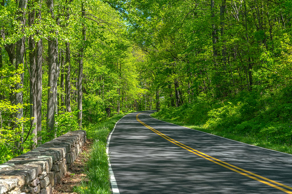
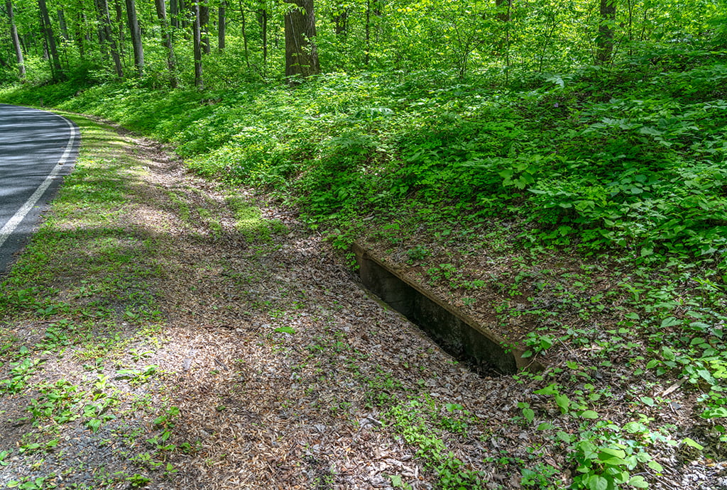
How many of you have driven or bicycled the length of Skyline Drive, stopping at a few, if not all the 75 overlooks built along both sides? While traversing road bordered by tall trees, wildflowers, flowering shrubs and emerald green vegetation, did you notice the dry-laid stone retaining walls and thick log guardrails? Did you spy oblong openings known as drop inlets at the bottom of hillsides next to the road, built to prevent flooding and undermining of the road from heavy water flow? Did you admire the overall aesthetics of the sweeping asphalt curves paralleling the ridge crest of the Blue Ridge Mountains?

How did this all come about?
A Need For More Eastern National Parks
In the Eastern United States, politicians, National Park Service (NPS) officials, and influential citizens all championed the need for more park units built east of the Mississippi River. Most national parks during the early 20th century were in the West, but the heaviest concentration of the nation’s population lived in the East. Shenandoah National Park was envisioned as the perfect place for this majority population to rest, recreate, and spend their money while enjoying stunning Southern Appalachian vistas. In fact, the road through Shenandoah was envisioned as the major feature offering not only views of the Shenandoah Valley and ancient, gentle Blue Ridge Mountains, but also much-needed employment opportunities for a population reeling from local and national events at that time (1926 – 1936). As such, work began on Skyline Drive even before there was a Shenandoah National Park!
Travel Before The Automobile
Before the proliferation of the automobile, people took trains to visit Western national parks, since that’s where most of these parks were located. It was quite a long, detailed affair because travel from the East to the West took time, planning, preparation, and money – everything only the wealthy possessed.
Enter mass production of the automobile. This invention – along with the building of more and better roads - allowed people of modest means to take to these roads and venture out into other parts of the country. A road trip with its attendant sightseeing opportunities was an adventure in and of itself for the general population, with the end destination of a national park as the cherry on top. It also meant more dollars in the pockets of gas stations, restaurants, lodging, and other retail operations lining those travel routes.
Hard Times
During 1930, Virginia suffered a severe drought restricting waterflow in rivers and streams while destroying food and feed crops. This drought lasted two years. Concomitantly, the economic downturn of the Great Depression (1929-1939) throttled the nation. Times were hard and people needed jobs. Shenandoah National Park, along with its "sky-line drive," would stimulate much-needed employment opportunities for area locals.
It also helped greatly that President Herbert Hoover, a fishing enthusiast with a private retreat (Rapidan Camp) located deep within the planned area of the park, was brought on board to advocate for both park and park road. Skyline Drive and a road connecting to Rapidan Camp would certainly allow easier access for a man who disliked riding horses. Using his presidential influence, he secured over $1 million to initiate the project.
Building Skyline Drive
Unlike most national parks and park roads built on land already in possession of the federal government, Shenandoah National Park and Skyline Drive would be built on private acreage owned by local homesteaders – residents who would ultimately need to vacate the premises, even though they were unaware of that at the time. While some occupants agreed to sell their land to the State of Virginia and move away, others refused and ultimately were forcibly displaced by the legal power of eminent domain, allowing the State of Virginia to seize this private land and donate it to the federal government for the building of the national park.
The start and end routes to Skyline Drive went through several alterations due to land prices and whether or not a few wealthy, influential private landowners would allow the eyesore of a road to disturb their view of the natural landscape. The die was cast when Franklin D. Roosevelt took office in 1933, holding the final say by enthusiastically promoting the north-south route of Skyline Drive, which would eventually segue onto the proposed Blue Ridge Parkway to connect visitors with the North Carolina portion of Great Smoky Mountains National Park.
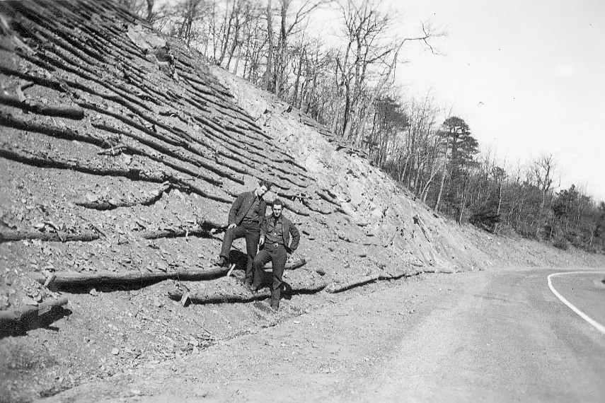
President Roosevelt accelerated Skyline Drive’s construction with the help of his “New Deal” Civilian Conservation Corps (CCC). Note: while the CCC did not engineer or build the road itself, they did landscape the route by planting thousands of native trees, shrubs, and wildflowers. They also built overlooks, road embankments, dry-laid stone retaining walls at overlooks and along the hillsides they graded, erosion and drainage controls, and log guard rails in addition to other infrastructure.
Skyline Drive was built in phases along different segments as funding became available. The central core of the road – a 34-mile (~55-kilometer) stretch between Thornton Gap (near Luray, VA) and Swift Run Gap (near Elkton, VA) – had been briefly opened to the public in 1932. Unpaved with no guard railing or rest areas, picnic or parking areas, and barely any overlooks, this segment was nonetheless so wildly popular with the public that NPS officials succumbed to political pressure and - despite the fact there was still no officially established national park – permanently opened that stretch of Skyline Drive to public use while road construction continued around them.

Swaths of land through which Skyline Drive ran had been plowed, clear cut, or blanketed with stands of unsightly dead chestnut trees caused by chestnut blight, a fungus accidentally introduced from Asia in the early 1900s. Bare hillsides created by road construction also presented blots on the landscape. Those were not the views administrator wanted motorists to see while driving through this new national park. As such, in addition to road engineers fine tuning the general aesthetic alignment of the road itself along the curving crestline, landscape architects were brought in to smarten up the views on either side the road. The beautiful forests, wildflowers and other verdant greenery you see today is the result of nine years’ manual labor by the young men of the CCC from 1933 - 1942.

Shenandoah National Park was formally established in 1935, and the final section of Skyline Drive was completed in 1939.
Skyline Drive Today
Just what will you see should you drive this park road today?
The road is quite curvy, with numerous blind spots. The posted speed limit throughout the entire park is 35 mph. It’s a good speed for admiring the roadside in addition to watching for unexpected wildlife crossings.

There are no road shoulders along Skyline Drive. Waysides (retail spaces), picnic areas, campgrounds, lodging, and overlooks offer the only parking.
Because there are no road shoulders, you’ll be sharing the road with bicyclists. Give them plenty of space and wait until you have rounded one of those blind curves before passing them.

Restrooms are few and far between. Originally, the plan for Skyline Drive included restrooms and waysides spaced every 10-15 miles. The NPS decided this would entail the removal of too much natural landscape, place too much pressure on water and power resources, and destroy the tranquil setting of Shenandoah.
Depending upon the time of year you visit, some of the overlooks will be overgrown with vegetation blocking the views. During the fall, this vegetation will be vibrant with shades of red, orange, and yellow. In winter and early spring, you’ll be able to see past the bare vegetation at those overlooks to the vistas beyond. During mid-late spring, Skyline Drive and the overlooks are lush and green, with swallowtail butterflies flitting on and off the many patches of colorful wildflowers.

Need to fuel your vehicle? There are gas pumps at the Big Meadows Wayside as well as in the communities outside the four park entrances. For those of you piloting electric vehicles, there is a charging station next to the Skyland Resort main office (milepost 41.7).

Skyline Drive’s length, trailheads, campgrounds, lodging, waysides, and other places of interest are measured with stone milepost markers consecutively numbered from north to south. Milepost 0 marks the northern entrance at Front Royal and milepost 105 is at the Rockfish Gap entrance to the south.

There are four entrances to Shenandoah National Park and Skyline Drive:
- Front Royal Entrance Station - (mile 0) by Rt. 66 and 340 in Front Royal, Virginia.
- Thornton Gap Entrance Station - (mile 31.5) by Rt. 211 near Luray, Virginia.
- Swift Run Gap Entrance Station - (mile 65.5) by Rt. 33 near Elkton, Virginia.
- Rockfish Gap Entrance Station - (mile 104.6) by Rt. 64 and Rt. 250.
As a photographer, I am so appreciative of these national park roads. During my spring visit to Shenandoah, Skyline Drive afforded me wonderful opportunities to capture the beauty of this national park in my images. It also sparked my interest in the history of both park and road.
If you are interested in more detailed accounts of the conception and construction of Skyline Drive, I recommend Reed L. Engle’s The Greatest Single Feature … A Sky-Line Drive: 75 Years Of A Mountaintop Motorway, and Timothy Davis’s National Park Roads: A Legacy In The American Landscape.
Stories about:
Story Categories:
A copy of National Parks Traveler's financial statements may be obtained by sending a stamped, self-addressed envelope to: National Parks Traveler, P.O. Box 980452, Park City, Utah 84098. National Parks Traveler was formed in the state of Utah for the purpose of informing and educating about national parks and protected areas.
Residents of the following states may obtain a copy of our financial and additional information as stated below:
- Florida: A COPY OF THE OFFICIAL REGISTRATION AND FINANCIAL INFORMATION FOR NATIONAL PARKS TRAVELER, (REGISTRATION NO. CH 51659), MAY BE OBTAINED FROM THE DIVISION OF CONSUMER SERVICES BY CALLING 800-435-7352 OR VISITING THEIR WEBSITE. REGISTRATION DOES NOT IMPLY ENDORSEMENT, APPROVAL, OR RECOMMENDATION BY THE STATE.
- Georgia: A full and fair description of the programs and financial statement summary of National Parks Traveler is available upon request at the office and phone number indicated above.
- Maryland: Documents and information submitted under the Maryland Solicitations Act are also available, for the cost of postage and copies, from the Secretary of State, State House, Annapolis, MD 21401 (410-974-5534).
- North Carolina: Financial information about this organization and a copy of its license are available from the State Solicitation Licensing Branch at 888-830-4989 or 919-807-2214. The license is not an endorsement by the State.
- Pennsylvania: The official registration and financial information of National Parks Traveler may be obtained from the Pennsylvania Department of State by calling 800-732-0999. Registration does not imply endorsement.
- Virginia: Financial statements are available from the Virginia Department of Agriculture and Consumer Services, 102 Governor Street, Richmond, Virginia 23219.
- Washington: National Parks Traveler is registered with Washington State’s Charities Program as required by law and additional information is available by calling 800-332-4483 or visiting www.sos.wa.gov/charities, or on file at Charities Division, Office of the Secretary of State, State of Washington, Olympia, WA 98504.

National parks and their natural resources belong to you. The National Parks Traveler works to ensure you know how these essential places are being cared for.
Sign Up For Our Weekly Newsletter
Unsubscribe at any time.
INN Member

The easiest way to explore RV-friendly National Park campgrounds.

Here’s the definitive guide to National Park System campgrounds where RVers can park their rigs.
Our app is packed with RVing- specific details on more than 250 campgrounds in more than 70 national parks.
You’ll also find stories about RVing in the parks, tips helpful if you’ve just recently become an RVer, and useful planning suggestions.
