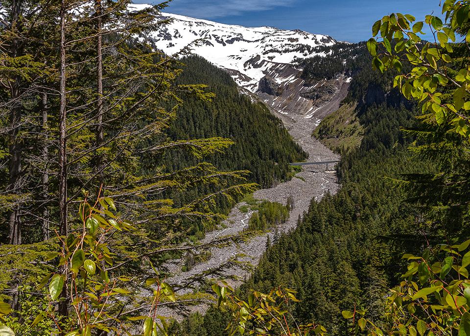
A view of Glacier Bridge and the Nisqually River as seen from Ricksecker Point, Mount Rainier National Park / Rebecca Latson
Time to test your park unit knowledge with this quiz #30. I’m pleased I’ve been able to create so many quizzes, but I have a way to go before I equal Professor Robert Janiskee’s past quizzes (he wrote over 100 of them). Now, I’m at the stage where I worry about accidentally writing something that was listed as a question in one of my previous quizzes. So far, I don’t think I’ve done that, but now that I mention it, it’s probably not if, but when. In the meantime, see how much you know about some of the National Park Service’s 423 units before checking the answers at the end of this piece.
1. At Glacier Bridge in Mount Rainier National Park, you can see the squiggly line of the Nisqually River as it flows down the valley. This natural dividing line connecting the lowest points along a river or valley. Lines of this type have often been used as “natural borderlines between properties and even countries.” There’s a term for this line:
a) demarcation line
b) moraine
c) thalweg
d) braided channel

The view from Big Badlands Overlook, Badlands National Park / NPS-Ed Welsh
2. The name “Badlands” in Badlands National Park is a literal translation of the Lakota Sioux term:
a) kadoka
b) owanka
c) capa
d) mako sica

Having fun in Medano Creek, Great Sand Dunes National Park and Preserve / National Park Service
3. Medano Creek, located in Great Sand Dunes National Park and Preserve, “is one of the few places in the world where one can experience ___.”
a) surge flow
b) pulse flow
c) riffle flow
d) glide flow
4. Which park unit has the largest collection of lighthouses?
b) Cape Hatteras National Seashore
c) Apostle Islands National Lakeshore
5. Lake Meredith National Recreation Area in Texas is home to the state reptile of Texas:
a) checkered whiptail lizard
b) collared lizard
c) Texas horned lizard
d) ornate box turtle
6. True or False: Mesa Verde National Park is one of the largest archaeological sites in southwest Colorado.
a) True
b) False

Rafters on Alagnak Wild River / NPS-Roy Wood
7. The headwaters of Alagnak Wild River lie within which Alaskan Mountain Range?
a) Aleutian Range
b) Alaska Range
c) Brooks Range
d) Laurentian Range
8. “During the restoration of the immigration station on Ellis Island in the 1980s, archaeologists revealed the island's buried past.” The first people to utilize the island were members of what Native American tribe?
a) Oneida
b) Seneca
c) Shinnecock
d) Algonquian
9. “Reeling from the effects of the Great Depression, a large group of World War I veterans marched to Washington, DC, in the spring of 1932 to demand the immediate payment of a wartime bonus. Nearly 11,000 marchers established a camp at present-day ________ in Washington, D.C., where they created shanties from cardboard boxes and scraps of wood.”
10. True or False: Shenandoah National Park is the largest example of columnar jointing in the world.
a) True
b) False
Trivia

Pu'ukohola Heiau (temple) and Mailekni Heiau, Pu'ukohola Heiau National Historic Site/NPS-M. Tadio
Pu’ukoholā National Historic Site on the island of Hawai’i is a place “where you can walk in the footsteps of a king. King Kamehameha was one of the most striking figures in Hawaiian history, a leader who united and ruled the islands during a time of great cultural change. Accounts vary, but many think that Kamehameha (originally named Pai'ea) was born into a royal family in North Kohala sometime between 1753 and 1761, possibly in November 1758. Kamehameha's mother was Kekuiapoiwa, daughter of a Kona chief. His father was probably Keoua, chief of Kohala. Legends link his birth to storms and strange lights, activities thought by Hawaiians to herald the birth of a great chief. Because of prognostications at his birth and threats from warring clans, Kamehameha was taken away and hidden immediately after his birth. He spent his early years secluded in Waipio, returning to Kailua at the age of five. He lived there with his parents until his father's death, then continued to receive special training from King Kalani'opu'u, his uncle. This training included skills in games, warfare, oral history, navigation, religious ceremonies, and other information necessary to become an ali'i-'ai-moku (a district chief).” To read more about Kamehameha, click here.

The ceiling of the Desert View Watchtower, Grand Canyon National Park / National Park Service
Salinas Pueblo Missions National Monument in New Mexico and Grand Canyon National Park in Arizona are linked by pictographs found near the ruins of Abó Mission, one of three missions protected by this national monument. “In 1908, Herman Schweizer of Albuquerque walked to the ruins of the Abó Mission to visit the Abó Painted Rocks site. This rocky overhang contained incredible Native American pictographs dating from the Pueblo IV period starting in 1300. These pictographs are interesting for their inclusion of images of both Puebloan and Plains cultures and for the variety of colors used in their design. Using Schweizer's drawings, [American architect] Mary Colter had artist Fred Greer decorate the ceiling of the Grand Canyon's Desert View Watchtower with pictographs from Abó during its construction in 1932. Curiously, these drawings include whole pictographs that today are missing or damaged at the Abó site. When Colter or one of her representatives visited the site in 1932 or 1933, some of the pictographs drawn by Schweizer in 1908 were already damaged and vandalized including the image of a Koshare figure, a Puebloan trickster or clown painted with black and white stripes. This figure was missing the top half of his body by 1932 or 1933, but appears whole on the ceiling of the Desert View Watchtower. Due to this damage, the pictographs on the ceiling of the Watchtower are a very important early glimpse of the pictographs from Salinas Pueblo Missions National Monument.”

"Some of those bones are my mother's bones," African Burial Ground National Monument / National Park Service
“African Burial Ground National Monument is the oldest and largest known excavated burial ground in North America for both free and enslaved Africans. It protects the historic role slavery played in building New York. Preliminary archaeological research excavation found intact human skeletal remains located 30 feet below the city’s street level on Broadway. During survey work, the largest and most important archeological discovery was made: Unearthing … a 6-acre burial ground containing upwards of 15,000 intact skeletal remains of enslaved and free Africans who lived and worked in colonial New York. The Burial Ground’s rediscovery altered the understanding and scholarship surrounding enslavement and its contribution to constructing New York City. The Burial Ground dates from the middle 1630s to 1795. Currently, the Burial Ground is the nation’s earliest and largest African burial ground rediscovered in the United States.”
Quiz Answers
1c
“The exact geography of a thalweg can change as often as the river changes course. The braided rivers of Mount Rainier fluctuate more than most, making their thalwegs poor borderlines.”
2d
For hundreds of years, the Lakota people have called this area mako sica, which literally translates to “bad lands.” To learn more about naming the Badlands and its history and culture, click here.
3a
Medano Creek “is one of the few places in the world where one can experience surge flow, a stream flowing in rhythmic waves on sand. Three elements are needed to produce the phenomenon: a relatively steep gradient to give the stream a high velocity; a smooth, mobile creekbed with little resistance; and sufficient water to create surges. In spring and early summer, these elements combine to make waves at Great Sand Dunes. As water flows across sand, sand dams or antidunes form on the creekbed, gathering water. When the water pressure is too great, the dams break, sending down a wave about every 20 seconds. In wet years, waves can surge up to a foot high!”

Old Michigan Lighthouse, Apostle Islands National Lakeshore / National Park Service
4c
“Within the boundaries of Apostle Islands National Lakeshore is the largest and finest single collection of lighthouses in the country.” To see and read about these lighthouses, click here.

Texas horned lizard / National Park Service
5c
A gimme, right? The Texas horned lizard, aka the Horny Toad “is the state reptile of Texas and listed as a Threatened species. It is easily recognized with its flattened body and rows of horns (spikes) from its head to its tail. Small in size, this lizard can squirt blood out of its eyes as a defense mechanism.” To read about the other reptiles that can be found at Lake Meredith National Recreation Area, click here.
6b False
Yucca House National Monument, “preserves one of the largest archeological sites in southwest Colorado. Yucca House … acted as an important community center for the Ancestral Puebloan people from AD 1150-1300. On July 2, 1919, Henry Van Kleeck deeded 9.6 acres of land, including most of Yucca House, to the federal government. Due to its significance as an excellent example of a valley pueblo, Woodrow Wilson made Yucca House a National Monument by Presidential Proclamation on December 19, 1919.”
7a
“The headwaters of Alagnak Wild River lie within the rugged Aleutian Range of neighboring Katmai National Park and Preserve. Meandering west towards Bristol Bay and the Bering Sea, the Alagnak traverses the beautiful Alaska Peninsula, providing an unparalleled opportunity to experience the unique wilderness, wildlife, and cultural heritage of southwest Alaska.”
8d
“During the restoration of the immigration station on Ellis Island in the 1980s, archaeologists revealed the island's buried past. The first people to utilize the island were Native Americans -- members of the Algonquian speaking tribes that lived in the northeast region of North America. They visited Ellis Island because it contained large oyster beds, which were an important source of food. As a result, the Dutch referred to the island as one of the three ‘Oyster Islands’ in New York Harbor.”
9b
“Nearly 11,000 marchers established a camp at the Anacostia Flats (present-day Anacostia Park), where they created shanties from cardboard boxes and scraps of wood. After Congress refused to meet the Bonus Marchers' demands, President Herbert Hoover ordered General Douglas MacArthur to remove them by force. Police and military personnel, including a tank unit led by Major Dwight D. Eisenhower, attacked the marchers on July 28, 1932, knocking down and setting fire to their shelters. Those not injured in the battle drifted back to their homes without the sought-after bonus.” To learn more about the Anacostia Park timeline, click here.

Devils Tower from the Joyner Ridge Trail, Devils Tower National Monument / NPS-S. Carter
10b False
Shenandoah National Park does have columnar jointing, but it’s Devils Tower, in Devils Tower National Monument, that is the largest example of columnar jointing in the world. To learn more about columnar jointing, click here.


 Support Essential Coverage of Essential Places


Comments
Well dang, Rebecca. A tough one for me - only 1 right 8-( But very interesting in spite of my poor showing!! Thanks again.