Editor's note: Yellowstone Caldera Chronicles is a weekly column written by scientists and collaborators of the Yellowstone Volcano Observatory. The following contribution is from Jamie Farrell, assistant research professor with the University of Utah Seismograph Stations and chief seismologist of the Yellowstone Volcano Observatory.
In a previous Yellowstone Caldera Chronicles article, we discussed the 1959 M7.3 Hebgen Lake earthquake that occurred just west of Yellowstone National Park. Because of this earthquake and the thousands of others that we record each year, we know that the area is seismically active and capable of producing large, damaging earthquakes. In fact, because of their rate of occurrence, large earthquakes represent one of the greatest geological hazards in the area, much more so than a volcanic eruption. The U.S. Geological Survey produces seismic hazard maps for the United States and the 2018 nationwide long-term assessment shows that the Yellowstone region has some of the highest seismic hazard values in the Intermountain West.
")
Earthquake hazard map showing peak ground accelerations having a 2 percent probability of being exceeded in 50 years, for a firm rock site. Black box outlines Yellowstone region. The map is based on the most recent USGS models for the conterminous U.S. (2018), Hawaii (1998), and Alaska (2007). The models are based on seismicity and fault-slip rates, and take into account the frequency of earthquakes of various magnitudes. Locally, the hazard may be greater than shown, because site geology may amplify ground motions.
One caveat in these numbers is that we are not locating every earthquake that happens in Yellowstone—or anywhere, for that matter. The ability to record and locate an earthquake is directly related to the number and distribution of seismometers in the region—the seismic network. When an earthquake happens, seismic energy propagates out in all directions, but that energy lessens as it travels away from the source. To get a location and an origin time for an earthquake, you need to record that earthquake on at least four stations. As a result, it is hard to record and locate very small earthquakes if you don't have a dense seismic array because you can't adequately record small earthquakes on enough stations—the energy from such small quakes dissipates too rapidly to be recorded across the seismic network.
")
Yellowstone earthquakes that occurred during 2010-2019. Blue symbols indicate events that occurred as part of swarms, while red indicates non-swarm seismicity. Map courtesy of the University of Utah Seismograph Stations.
While most earthquakes in the Yellowstone region are in the M0–2 range, there are always a few that are M3 or higher and that are felt by people in the area. The largest quake of the past several years was a M4.8 that occurred near Norris Geyser Basin in March 2014 and that was felt widely across the area. Over the past decade, there were 54 felt events in the Yellowstone region giving an average of ~5 felt earthquakes every year. However, of the 54 felt events, 38 were part of either the 2010 Madison Plateau swarm or the 2017-2018 Maple Creek swarm. So while there is always a chance that visitors to Yellowstone will feel an earthquake, the chances increase if there is a significant swarm occurring!
")
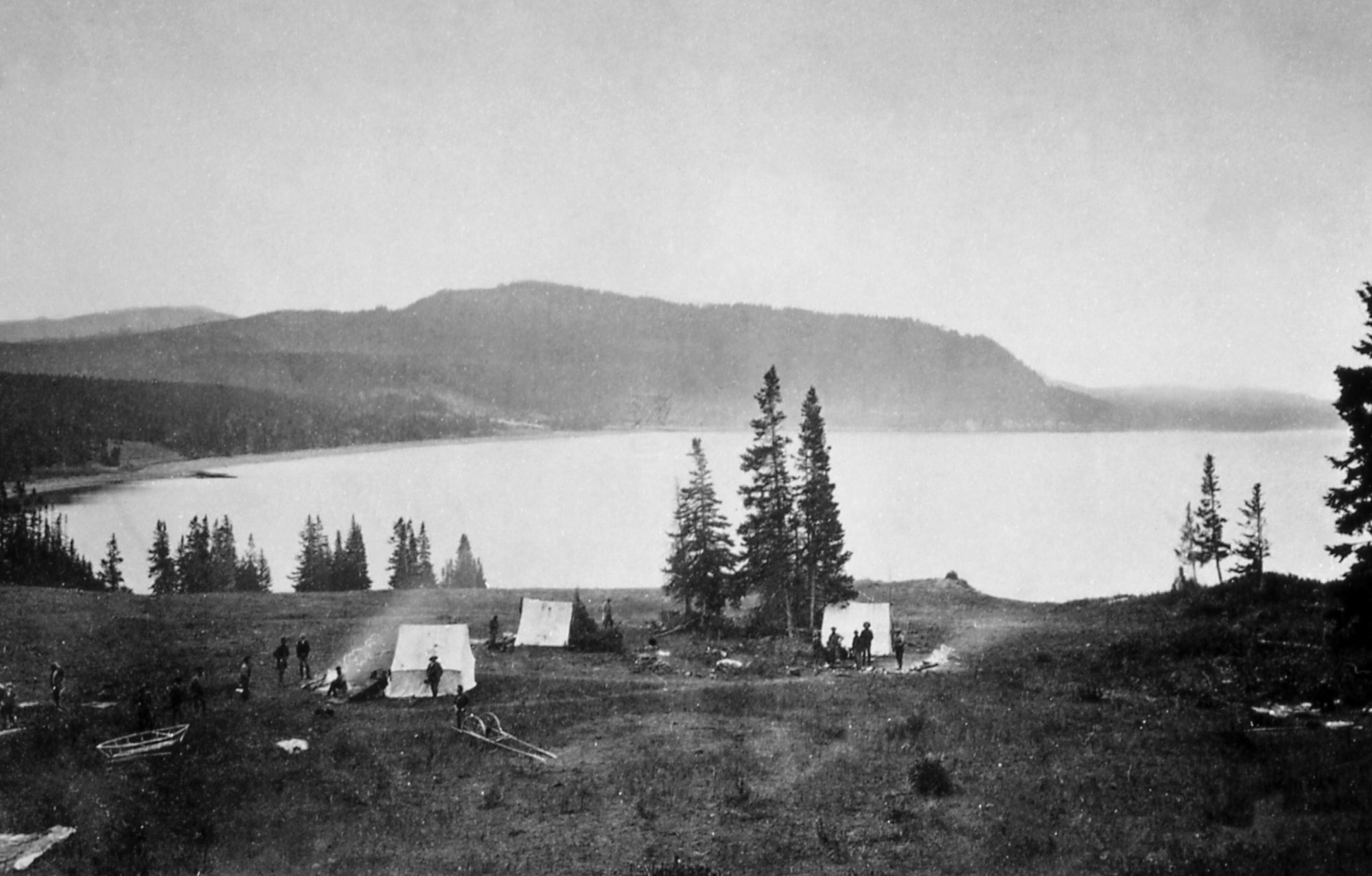
"Earthquake camp" of the Hayden expedition in 1871, located on the north shore of Yellowstone Lake near Steamboat Point. Photo by William H. Jackson, courtesy Yellowstone National Park (https://www.nps.gov/features/yell/slidefile/history/jacksonphotos/Images...).
"This morning [August 20] about 1 o'clock we had quite an earthquake. The first schock [sic] lasted about 20 seconds and was followed by five or six shorter ones. Duncan, who was on guard, says that the trees were shaken and that the horses that were lying on the ground sprang to their feet ... We had three shocks during the morning."
Because of the earthquakes that they felt in this area, they named this camp "Earthquake Camp." These earthquakes were probably part of a swarm.
So, the next time you visit Yellowstone, we can virtually guarantee that there will be earthquakes occurring while you are there. The odds are that you won't feel any of these quakes, but there's always a chance that a felt event may occur, and an outside chance that the event could be strong, like those that have struck the Yellowstone area in the past. Remember—Yellowstone is earthquake country, and people should be prepared for the consequences of damaging events.


Comments
I'm wondering if Yellowstone is showing signs of a eruption , with the amount of large quakes in the past week and the 6.5 directly west ?
Tigle, here is a source of excellent and accurate information about Yellowstone: https://volcanoes.usgs.gov/observatories/yvo/yvo_news_archive.html?utm_s...
Or, for info on volcanoes in general, here's the master website: volcanos.usgs.gov