

Editor's note: The following article came from Eos, the leading source for trustworthy news and perspectives about the Earth and space sciences and their impact. It was written by Amy Combs, and editorial intern. Coombs, A. (2016), Six snapshots of geoscience research from national parks, Eos, 97, doi:10.1029/2016EO058109. Published on 25 August 2016.
As the National Park Service celebrates its 100th anniversary, we celebrate ongoing Earth and atmospheric research made possible by conservation efforts.
On 25 August 1916, President Woodrow Wilson signed an act designating the National Park Service as a new bureau in the Department of the Interior. The act aimed to protect America’s most spectacular landscapes for future generations. Now, 100 years later, visitors from all over the world enjoy 34 million hectares of historical sites, geological formations, and habitat for rare and endangered species.

Castle Geyser, Yellowstone National Park/Flicka, CC BY-SA 3.0
To geoscientists, however, this legacy of conservation means something more. It provides opportunities to study geological processes up close, to see how protected landscapes influence ecology, and to observe the effects of humankind in even the most remote places. More than 25,000 investigator permits were issued between 2011 and 2015, allowing researchers to collect data in some of the most ecologically and geologically rich repositories in the world. Whether researchers are using the parks to discover new scientific insights or applying science to challenges that the national parks face, “the parks are an important national laboratory for science,” said Gary Machlis, the first scientific adviser to a National Park Service director, in a recent interview with Eos.
At the towering cathedral cliffs of Yosemite, scientists discovered that in addition to seasonal freeze-thaw cycles, daily temperature fluctuations exfoliate rock faces, causing giant slabs of granite to fall. Excavations within the extinct continental rift preserved at Isle Royale National Park uncovered ancient copper mines dug by Native Americans. Carbon dioxide dissolved in hydrothermal waters may play a stronger role in triggering geyser eruptions at Yellowstone than previously thought. And at the Grand Canyon, researchers are learning about sediment deposition and erosion by restoring damaged banks and sandbars altered over many years by upstream dams.
Here are six more snapshots of research, courtesy of our National Park Service.
1. A Massive Landslide Once Covered Bryce Canyon
Located in southwest Utah, Bryce Canyon National Park straddles the rim of a high-elevation plateau and is full of oddly shaped red sandstone pillars called hoodoos—each the remnant of hundreds or thousands of years of erosion. According to new research, the northern part of this major tourist destination was once buried by debris from one of the world’s largest continental landslides.

Hoodoos—oddly shaped sandstone pillars—in Bryce Canyon National Park/Brian Poicus CC BY 2.0
Nearly 28 million years ago, a large volcanic field consisting of several calderas and volcanoes collapsed in a matter of minutes, according to Utah Geological Survey scientist Robert Biek and his colleagues. The researchers discovered evidence for this massive event last summer and labeled it the Sevier gravity slide.
“The slide got hot enough to melt the rock to the consistency of taffy,” said Biek. Samples indicate that the falling rock moved fast enough to pulverize even ultrahard volcanic rock into fragments the size of flour and rice. The findings will be presented in September during a series of talks at the Geological Society of America meeting in Denver.
“The slide got hot enough to melt the rock to the consistency of taffy.”
Why such a big slide? “We don’t know what the immediate triggers were, but the volcanic field sat on weak clay,” said David Hacker, a geologist at Kent State University in Ohio who helped Biek map the area.
Scientists hypothesize that inflation from volcanic activity tilted the region, causing the weak clay underneath to collapse from the weight of the spreading volcanic field. Signs of this uplift and tilt can be seen in the park’s rich stratigraphy—the researchers point to a thrust fault that pushed bright orange bands of clay southward over younger rocks. Dating studies show this lift occurred in the time period before the field is thought to have collapsed.

Named after a hotel in the park, the Ruby’s Inn Thrust Fault Zone in Bryce Canyon contains a stratigraphic record of uplift and tilting in the park/Robert Biek
Remarkably, the Sevier gravity slide is the second catastrophic event Biek and Hacker found in the Bryce Canyon area. In 2014 the team identified the Markagunt gravity slide, which occurred about 22 million years ago outside the boundary of the park. That slide covered an area the size of Rhode Island, about the same area as the previous record holder for the world’s largest known deep history landslide—the Heart Mountain event that occurred outside Yellowstone National Park about 48 million years ago.
Given the stories of these landslides, researchers from around the world are beginning to reexamine other volcanic fields for evidence of large prehistoric landslides. “There are probably slides left unrecognized because they are so darn big,” says Biek.
2. Halibut Habitat in Glacier Bay Helps Supreme Court Case

A glacier meets the ocean at Glacier Bay National Park and Preserve/Eric Frommer, CC BY-SA 2.0
In the 18th century, Alaska’s Glacier Bay was covered in a thick sheet of ice. As this glacier slowly receded, it left icebergs that scraped gouges into the ocean floor. According to researchers, the discovery of these grooves and the species they support helped influence a 2006 U.S. Supreme Court decision that protected ocean life from commercial fishing.

Looking out at Glacier Bay through an ice cave/NPS
In November 1999, “the state of Alaska had sued to limit federal jurisdiction over Glacier Bay waters—the National Park Service was embroiled in litigation that stood to limit management to land-based ecosystems,” said Glacier Bay National Park and Preserve superintendent Philip Hooge, who studied the grooves while a researcher with the U.S. Geological Survey (USGS). Fortuitously, when Hooge and collaborators first shared the discovery with park staff, the special master from the Supreme Court was visiting, on a trip to review evidence.
The suit, filed by the state of Alaska, stood to benefit commercial halibut and crab fishing operations, which the National Park Service had barred from using Glacier Bay in the 1990s. The ecological models put forward by commercial fisheries suggested that halibut and other fish commonly migrated long distances beyond the park boundary and spawned outside the park, which in turn suggested that restrictions in Glacier Bay would do little to protect fisheries.
If the suit were successful, National Park Service oversight would, by default, be limited to land-based species, said Hooge.
However, the researchers discovered that the iceberg gouges were teeming with halibut. Fish surveys conducted in the grooves showed that small halibut spent long periods of time in deeper grooves. Older, larger fish burrowed in the sediment layers found in shallower gouges that had partially filled with silt. “We found that halibut had more localized ranges than previously thought and that the park played a key role in preserving marine habitat,” Hooge added.
“We showed that the same glacier processes that motivated the initial protection of parkland extended well into marine areas.”
Multibeam echo sounding sonar found a dense network of grooves that varied from 1 to 3 meters deep. Some stretched 20 meters wide and were as long as 1 to 5 kilometers. The grooves’ geometry revealed that they formed when massive icebergs ran aground many years ago and pushed boulders aside, said study coauthor Guy Cochrane of the USGS in Santa Cruz, Calif.
The findings were published in the American Fisheries Society Symposium in September 2005, just months after the Supreme Court delivered its opinion in favor of federal jurisdiction, and thus National Park Service management, of Glacier Bay waters on 6 June 2005.
According to Hooge, the paper became a symbolic piece. “We showed that the same glacier processes that motivated the initial protection of parkland extended well into marine areas,” said Hooge. “The land and marine system began as one unit and the ecosystem still reflected this history.”
3. Sulfuric Acid Carved Caves at Carlsbad

Lily pad cave formations can be found standing on top of stalagmites, hanging from stalactites, or stuck between the two as part of a column at Lechuguilla Cave/Daniel Chailloux and Peter Bosted, NPS
Hidden beneath the flowering cactus and shrubs of the Guadalupe Mountains of southeastern New Mexico lies a network of more than 119 fragile limestone caves protected by Carlsbad Caverns National Park. The unusual formation of the caves was at first hotly debated, but what began as a far-fetched hypothesis is now used to explain cavern formation in several rare caves around the world.
It is now believed that the expansive hollow rooms in Carlsbad Caverns formed when hydrogen sulfide leaked upward along fractures from the underlying oil and gas deposits in the nearby Delaware Basin. After reaching oxygen-rich groundwater, sulfuric acid formed, dissolving large voids inside the mountain’s limestone rock.
“Only 5% of the caves in the world were dissolved by this method, so it’s rare.”
“Only 5% of the caves in the world were dissolved by this method, so it’s rare,” said David Jagnow, who proposed the theory while he was a master’s student at the University of New Mexico in Albuquerque, before he launched a career as a petroleum geologist at Shell Oil Company in Houston, Texas. “In the early 1970s this was a new idea, so I was sticking my neck out pretty far.”
After finding 10-meter-thick deposits of calcium sulfate—gypsum—in Carlsbad Caverns, Jagnow was among the first to suggest that sulfuric acid had dissolved calcium carbonate in the limestone. “The calcium sulfate indicated that a sulfuric acid reaction had taken place,” said Jagnow. However, his idea of cave formation was contested while debates raged over the source of sulfuric acid.

A caver views massive gypsum chandeliers in the Chandelier Ballroom at Lechuguilla Cave/Max Wisshak, NPS
The mystery was settled when a cavern called Lechuguilla Cave was finally explored in the late 1980s. Although the cavern had been known as a large bat habitat since at least 1914, the cavern itself was thought to have contained only a 30-meter entrance pit and about 120 meters of dry, dead-end passages. Over the next decades, cave explorers heard wind rumbling through the floor and believed that other caverns lay hidden, but it wasn’t until 1986 that experts with an exploratory permit from the National Park Service dug an entrance to a staggering 220 kilometers of passage.
The discovery paved the way for a 1989 survey conducted by USGS scientist Kimberley Cunningham, who studied whole-rock sulfur isotope ratios and the concentration of gases and fluids in the cave. Hydrocarbons turned up in the samples, lending credence to the idea that the massive gypsum deposits formed after gas escaped from petroleum deposits located beneath the water table.
More than 300 caves are now thought to have been hollowed by sulfuric acid in the Guadalupe Mountains. The theory is also used to explain far-away caverns such as the Fiume-Vento Cave in Italy, Turkmenistan’s Kugitangtou caves, and Las Brujas Cave in Argentina, as well as caves in the Grand Canyon and Wyoming. “It took about 20 years before the National Park Service hung signs saying that the caverns were formed by sulfuric acid,” said Jagnow. “Nowadays it’s a widely accepted theory.”
4. Climate Change May Mismatch Bird Migration and Food Availability in Acadia
Located along the Atlantic shore of Maine, Acadia was the first national park established on the East Coast. The 19,020 hectares of woodland and granite peaks are home to many migratory songbirds. These birds are potentially under threat because climate change is affecting their migration routes at the same time it alters the availability of food sources.

Marshes at Acadia National Park’s Eagle Lake/Dave Hensley, CC-BY-NC-ND 2.0
“We are concerned that fruits are ripening earlier while the birds are migrating later,” said Abraham Miller-Rushing, science coordinator at Acadia National Park.
To understand the effects of climate change on migration and the availability of foods like berries and insects, researchers at the National Park Service recently launched a large-scale regional study of phenology—the changes in ecological cycles from year to year. The study will include several songbirds identified as species of special concern by the state of Maine, such as the yellow-billed cuckoo (Coccyzus americanus), the American redstart (Setophaga ruticilla), and the black-and-white warbler (Mniotilta varia), among others.
Many of these species have a primary diet of insects in the spring and summer but may switch to fruit in the fall during their migration. The study is looking at the fruits these birds eat, including black huckleberry (Gaylussacia baccata), mountain holly (Ilex mucronata), wild raisin (Viburnum nudum), and others, in an effort to track when buds start to form and fruit starts to ripen.
The study questions whether changes to the onset of ripening influence food availability during new migration time periods. Data must be collected over many years and at large spatial scales in numerous habitats to conclusively demonstrate phenological mismatches between, say, when berries ripen and when birds migrate overhead.
. Credit: iStock.com/ManaVonLamac")
Black-and-white warbler (Mniotilta varia)/iStock.com/ManaVonLamac
Yet some broader phenological results have already been firmly established. According to Katharine Gerst, a scientist with the USA National Phenology Network in Tucson, Ariz., research conducted over recent years shows extremely early springs in many East Coast national parks compared to the historical range of variation.
The network has archived more than 1.8 million records from national parks and open space preserves across the nation, including data from Miller-Rushing’s team. These records facilitate studies of numerous phenology variables, including nutrient cycling, the timing of pollinator and flower availability, and the migration patterns of predators and prey.
Acadia is among 16 parks celebrated in a recently issued set of parks centennial postage stamps.
5. Magma Supply Affects Eruption Rates at Hawaii Volcanoes

Explosion sends lava fragments skyward at Kīlauea Volcano’s ocean entry in 1969/B. Gaddis, USGS
Kīlauea Volcano is one of the most active volcanoes in the world and a feature attraction at Hawai‘i Volcanoes National Park. It is also a public nuisance—communities continually face threats from lava flows and volcanic smog.
These problems motivated several studies designed to better understand and predict eruption activity, including a recent survey of magma supply from the hot spot that feeds Hawaii. “Sometimes the magma supply increases, and this causes the eruption rate to increase, and even results in new eruptive activity,” said Michael Poland, a volcanologist with the USGS who conducts research in Hawai‘i Volcanoes National Park.
In a study of magma supply to Kīlauea, published in 2012 in Nature Geoscience, Poland and his colleagues used GPS receivers placed in numerous locations around the volcano, as well as satellite radar data, to trace the degree of swelling caused by a magma influx.

Night view of Kīlauea’s Halema‘uma‘u crater, in Hawai‘i Volcanoes National Park/S. Geiger, NPS
The readings from the instruments indicated that magma supply began increasing in 2003 and peaked in 2006. It remained high through 2007. This pattern correlated with an increase in volcanic activity that began in 2005, when the eruption rate nearly doubled.
By 16 June 2007, the volcano had swelled with so much magma that it burst along the East Rift Zone, where a new eruption site formed and spewed lava for a few hours. A new summit eruption—the first since 1982—occurred in 2008 and continues to this day. “A lot of this activity is due to the increase in magma supply that we saw in the early 2000s,” said Poland.
Poland and his colleagues also found that carbon dioxide (CO2) emissions peaked years before the surge in magma supply itself, suggesting that the CO2 ascended faster than the magma from which it was released. “We hope to be able to anticipate changes in the magma supply by tracking CO2,” said Poland.
6. Rock Colors at Zion, Capitol Reef, and Canyonlands Help Scientists Search For Water on Mars
Not all sandstone is the same color even within a single formation—in fact, some of the Jurassic Navajo Sandstone exposed in Zion, Capitol Reef, and Canyonlands national parks in southern Utah is richly hued with bright red, pink-orange, and even white colors. According to recent findings, color variations are likely due to the movement of fluids through the rock over time.

The road to Canyonlands National Park/trevorklatko, CC BY-NC 2.0
“Mother Nature’s artistry is based on iron as the pigment of the color palette. Iron is cycling through the Earth’s sedimentary crust via fluid flow, and the coloration left behind is a record of this process,” said Marjorie Chan, a geologist at the University of Utah who outlined the basic chemistry of red rock color in a series of papers.
“Earth analogs from public lands provided valuable insight into the Mars geology.”
First, Chan and colleagues collected representative samples of visually distinctive Navajo Sandstone colors. Then, the researchers used microscope techniques, X-ray diffraction, and mass spectrometry technology to identify the mineral and pigment compositions of each sample.
Their findings painted a rich picture. The porosity of sandstones varied; highly porous rock indicated early water infiltration, and cements gave indications of where water couldn’t permeate. In addition, coatings of iron oxide residues encapsulated grains of sandstone and were found in a higher concentration in dusky brown to red colored sandstone but in lower levels in yellow-orange rock.
White rock was porous and largely missing iron-rich grain coatings, suggesting that chemicals in paleogroundwater “bleached“ the sandstone over time. “Hydrocarbons, acidic fluids, or carbon dioxide are chemically capable of bleaching the sandstone white,” said Chan.
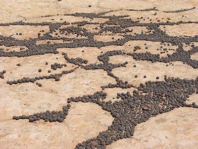
Iron concretions are found in many locations in southern Utah’s red rock desert
The findings have been cited by researchers interested in the Martian environment, where concentrated iron oxide minerals might indicate the presence of water long ago. The Mars rover Opportunity imaged small round “blueberries“ similar in structure and formation to the circular concretions of iron oxide commonly found in Utah’s red rock desert.
“You can imagine our delight when we saw the pictures of blueberries,” said Chan. “This suggested to us that there was indeed past water on Mars that had moved through the subsurface. Here, the Earth analogs from public lands provided valuable insight into the Mars geology.”


