Public comment is being taken through September 4 on an ORV management plan for Cape Lookout National Seashore/Kurt Repanshek
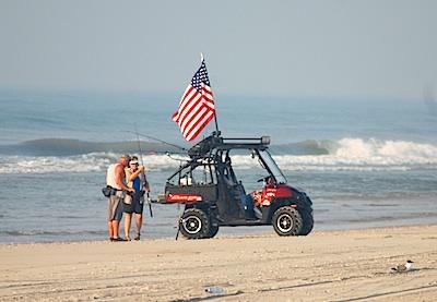
Off-road vehicles would be able to travel most of Cape Lookout National Seashore under a draft management plan, which also would create three "pedestrian only" areas on the seashore.
Though not nearly as controversial as the off-road management plan at Cape Hatteras National Seashore just to the north on the North Carolina coast, the proposed Cape Lookout National Seashore Off-Road Vehicle Management Plan/Environmental Impact Statement aims to put specific numbers to ORV traffic, specify where they can travel, formally set speed limits, and set seasons for when they can travel on the seashore.
Efforts to provide pedestrian only access during the summer months would cause the mileage open to ORVs to seesaw just a bit:
Under the seashore's preferred alternative in the draft plan, 44 of the seashore's 56 miles would be open to ORVs from March 16 "through the Thursday preceding Memorial Day and from the day after Labor Day through December 15." Forty-one of those miles "would be available for ORV use from the Friday proceeding Memorial Day through Labor Day. Routes within the Cape Lookout Village Historic District would be open to through vehicle traffic."
The pedestrian-only areas would include the entire length of the seashore from December 16 through March 15. From March 16 through December 15, pedestrian-only areas would include "Portsmouth Village, an expanded lighthouse beach, and Power Squadron Spit from approximately mile marker 46 to the end of the spit, and all of Shackleford Banks."
Pedestrian-only areas would be expanded during the summer (defined as from the Friday preceeding Memorial Day through Labor Day) would include the following:
* Long Point: On the ocean beach at the Long Point Cabin Camp for a day-use beach and a separate tent camping area for a total pedestrian-only area of about 0.50 miles, to be determined by beach profile.
* Great Island: On the ocean beach at the Great Island Cabin Camp for a day-use beach and a separate tent camping area for a total pedestrian-only area of 1.9 miles, to be determined by beach profile.
* Codds Creek: On the ocean beach near Codds Creek for a total closure of 0.8 miles between ramps 35a and 35b for pedestrians only. Camping would be allowed in this area, except for the north end turtle relocation site.
* Light Station: The pedestrian-only area at the lighthouse would be expanded approximately 0.7 miles to the south and would run from ramp 41a to ramp 42a (at the NOAA weather buoy) for a total closure of about 1.4 miles year-round, to provide visitors at the ferry hub a bigger stretch of vehicle-free beach.
Under the plan, which is open for public comment through September 4, ORV speed limits would be set at 25 mph along the beach and other designated routes, or as posted, and at 15 mph when within 100 feet of any "person, vehicle, campsite, other structure..." There also would be restrictions on night driving from May 1 through September 14 each year "to reduce potential impacts to turtles and bird chicks."
The plan also would allow up to four additional "ramps" that would provide access to the ocean-side of the national seashore from the "back route" on the sound side. And it would continue a prohibition "of all high-performance sport-model and two-stroke ATVs and UTVs (after a five-year grace period) and seasonal restrictions on all other ATVs and UTVs" due to their impacts on shorebirds. According to the draft plan, these vehicles likely flush birds more than other ORVs because of the noise they generate.
Proposed fees for ORV permits range from $80 for a ten-day permit to $150 for an annual permit.
The initial limit on the number of vehicle permits issued would be 2,500 permits annually for the North Core Banks and 3,000 permits annually for the South Core Banks, which is based on the average number of ORVs delivered to each island from 2005 through 2012. A limit on the number of vehicle permits issued per year would be established in year 4 of this ORV management plan/EIS, based on the average number of permits issued per island in years 1'3. Permits would be issued on a first-come, first-served basis. An annual lottery may be established to equitably allocate permits.
As with Cape Hatteras National Seashore, ORV use at Cape Lookout existed long before the national seashore was established. It also was not addressed in the seashore's enabling legislation.
"Beginning in the 1930s, vehicles were transported to the banks by shallow draft ferries and were used to provide access to productive commercial and recreation fishing spots, as well as for other recreational pursuits such as sightseeing and camping. Today, ORVs provide vehicular access to the Seashore beaches for recreational purposes, including activities such as surf-fishing, surfing, sunbathing, swimming, bird-watching, camping, visiting historic structures and site seeing, among other activities," the draft plan notes.
As with Cape Hatteras, sensitive species at Cape Look are driving the ORV guidelines. While some comments collected by the seashore during the planning stages suggested that the park staff move bird or turtle nests and eggs away from ORV corridors, staff said that wouldn't work as piping plovers and American oystercatchers more than likely would abandon their nests under such circumstances.
While turtle nests could be moved without concern for abandonment, "studies indicate that the determination of the hatchling sex ratio depends on the temperature at which the eggs incubate. Changes in these temperatures due to moving the eggs may result in changes to the sex ratio, having implications for the species as a whole. Handling eggs can result in increased hatch failure. When relocating nests, there is a risk of disrupting the membranes inside the egg, which can kill the embryo," the draft EIS notes.
Seashore staff also declined requests to allow for an off-leash area for dogs. While there were requests during the planning stages to include more restrooms, dump stations, and water pumps on the national seashore, park staff said those elements were not central to the off-road vehicle management plan, and so would not be considered at this time.
You can read the entire plan, and comment on it, at this site.


Comments
Well, if you like anarchists and posers, then that group is for you.
I'm not a political elite, mr. ambulance chaser. And SFWhine is not really anything but an impotent gnat in the grand scheme of things. Mere parochial buffoons...
Please, let's stick to the topic and not cast bricks...
If you actually knew the statistics for visitation, you would know this is the busiest time of year. Your anecdotal observations are as good as mine. One local business was recently quoted "notes that with difficulties getting on local beaches in the fall, they’ve seen a huge drop in annual visitors who chased blues and other fish that time of year". Its the shoulder seasons, when the fishermen used to come, that has been affected. You can dishonestly spin it your way though.
This is not correct, perhaps you have forgotten the name of Cape Hatteras National Seashore Recreational Area. Remember this part from CHNSRA's EL, " said area shall be, and is, established, dedicated, and set apart as a national seashore recreational area for the benefit and enjoyment of the people and shall be known as the Cape Hatteras National Seashore Recreational Area"
As with CHNSRA and CLNS, recreation was supposed to be primary use, but now the NPS is changing that. I can't seem to find a difference between a "wildlife refuge" and "recreational area" in the new world of the NPS.
bdumb...
I get it. "Recreation Area" in your world means "I can trample and run over birds and turtles as I recreate area".
Just because a public area is dedicated to a specific purpose doesn't mean that you can go there expecting to be allowed to sell heroin, beat baby seals, or marry your sister. Other laws, including protecting other species, still apply.
OK, folks, we've had enough. We're moving on. Nothing more to see here...