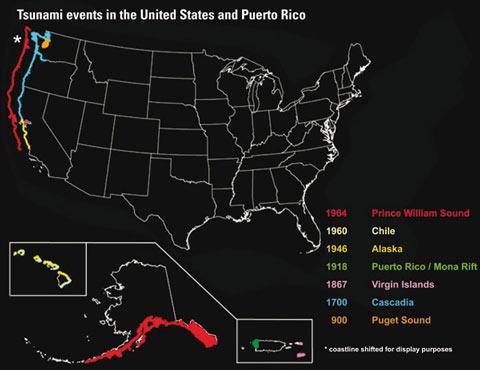
The staff at Redwood National and State Parks has gone the extra mile to prepare for a hazard most visitors don't think about very often: a tsunami. The park is the first NPS area to earn TsunamiReady designation by the National Weather Service. Here's a quick tsunami primer.
Tsunamis make good fodder for Hollywood eco-thrillers and TV shows such as The Weather Channel's "It Could Happen Tomorrow" features potential natural disasters—but is this really an issue? The U. S. Geological Survey (USGS) points out that
• Tsunamis are triggered by earthquakes, volcanic eruptions, submarine landslides, and by onshore landslides in which large volumes of debris fall into the water. All of these triggers can occur in the United States.
• devastating tsunamis have struck North America before and are sure to strike again. Especially vulnerable are the five Pacific States—Hawaii, Alaska, Washington, Oregon, and California—and the U.S. Caribbean islands.
• The 1964 Alaska tsunami led to 110 deaths, some as far away as Crescent City, California; in 1918, an earthquake and tsunami killed 118 people in Puerto Rico. Several such events have struck this region in historic times.
• If a tsunami-causing disturbance occurs close to the coastline, a resulting tsunami can reach coastal communities within minutes.
• Although many people think of a tsunami as a single, breaking wave, it typically consists of multiple waves that rush ashore like a fast-rising tide with powerful currents. Tsunamis can travel much farther inland than normal waves.
According to the USGS, in the wake of the Indian Ocean disaster, the United States is redoubling its efforts to assess the Nation’s tsunami hazards, provide tsunami education, and improve its system for tsunami warning.
The good news is that some public officials are working to prevent a catastrophe similar to the December 2004 tragedy, when a tsunami killed more than 200,000 people in 11 countries around the Indian Ocean.
Those efforts have been taken seriously by the staff at Redwood National and State Parks, and those areas have been recognized by the National Weather Service as TsunamiReady, making the park the first NPS area to earn that designation.
The TsunamiReady program, which was developed by the National Weather Service, is designed to help towns, cities, counties and other large sites in coastal areas to reduce the potential for disastrous tsunami-related consequences.
Employees at Redwood National and State Parks accomplished this recognition by completing a tsunami contingency plan, developing an employee tsunami response plan, and preparing an ocean safety brochure including tsunami information for park visitors.
Employees have also participated in tsunami exercises with the Office of Emergency Services in Humboldt and Del Norte counties, and have taken an integrated emergency management course on dealing with tsunamis with local emergency responders from Humboldt County at the Emergency Management Institute in Emmitsburg, Maryland.
Troy Nicolini, the National Weather Service tsunami coordinator for Northern California, presented a TsunamiReady plaque to NPS Superintendent Steve Chaney and California State Park Supervising Ranger Brett Silver. Nicolini commented the park accomplished many things that were well beyond the requirements for being designated TsunamiReady.
“Redwood National and State Parks employees have reached out to local communities to assist them in also achieving their TsunamiReady designations,” she said. “This has definitely been a community effort.”
If you'd like more information about tsunami hazards and safety in the U.S., you'll find it on the National Weather Service website. You can also download a brief fact sheet from the USGS.
Are tsunamis a low probability? Perhaps, but the staff at Redwood deserves kudos for their proactive efforts to make the park safer for anyone who visits the area. This is one situation when it's way too late to figure out what to do once you hear the words, "surf's up."


Comments
Obviously this is one of those plans you hope you will never need.
Interesting. I always hear tsunami preparedness in association with the Oregon coast, but, not with the Redwood parks. This is a good thing.
Thanks Jim.
Robert Mutch
Executive Director,
Crater Lake Institute
www.craterlakeinstitute.com
Several of the more isolated towns along the northern California coast have tsunami warning systems and plans, as there's historic record of their occurrence.
While tsunamis are much more frequent or likely on the north Pacific coast, if and when the undersea landslide happens in the Azores, the resulting tsunami has a straight shot at flowing over all of Miami and well into (or across) Everglades NP. I doubt that EVER will ever get tsunami certified. The options appeared to be climbing one of the Mt. Trashmores in south Florida, or attempting to catch the lead wave in an airboat and surf it across the Everglades.
Nice post. World has been facing varied natural disasters in which millions of people have died and amounting of losses increased.But we can't control the natural disasters. Tsunami occured on 26 December 2004. It happened at the epic centre off the west coast of Sumatra, Indonesia. 230,000 people died in over 11 countries, the tsunami waves were as high as 30 meters that is 100 feet high. It caused major damage to India, Indonesia, Sri Lanka and Thailand. The earthquake was of 9.3 magnitude, one of the 2nd largest recorded on seismograph. There were many deaths and damages to property in Maldives, Myanmar, Somalia, Sri Lanka and Thailand. For more details refer http://www.journeyidea.com/information-on-tsunami/