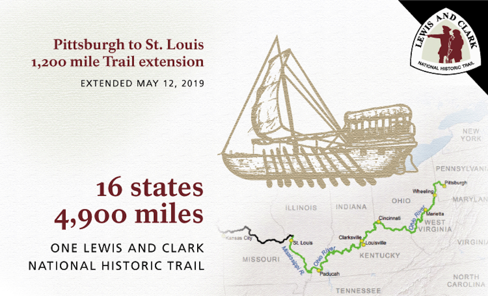
The Lewis and Clark National Historic Trail has officially gained 1,200 miles/NPS
Faithful students of American history know that Lewis and Clark started out from Pittsburgh, Pennsylvania, for their historic trek across the West to the Pacific Ocean. And now the Lewis and Clark National Historic Trail reflects that fact.
On Tuesday the trail officially was extended to include Eastern sites that played vital roles in the planning and supply procurement for the expedition. With a new historical trail-head at the Ohio River in Pittsburgh, Pennsylvania, the trail now winds 4,900 miles to St. Louis, Missouri, along the Missouri River to the Great Plains, across the Rockies and on to the Pacific Ocean.
This week, the National Park Service is celebrating the first anniversary of this 1,200-mile extension. The trail extension has increased opportunities for interpretation and education. The extension also highlights recreational opportunities along the Ohio and Mississippi rivers and engages partners and stakeholders in trail management and related activities.
National Park Service staff continues to work with partners and communities to integrate the new trail extension with the existing trail and continue to build strong state and local partnerships. Much progress has been made in the last year to incorporate these new sections in the larger national historic trail.
- The State of Kentucky and Indiana have officially identified the auto tour routes through their states. Many visitors follow the Lewis and Clark story through the auto tour routes. An auto tour route for a national historic trail is an officially recognized and signed existing public road that parallels the actual historic trail route.
- More than 30 sites with connections to the Lewis and Clark story have put up the Lewis and Clark National Historic Trail emblem so visitors know they are traveling on the trail.
- Many members of the trail staff have traveled the new section of trail, meeting partners and forming connections to assist in future projects.
- Two kickoff events were held for the dedication of the new trail sections.
- More than 200 entries have been added to the Lewis and Clark National Historic Trail Experience website, and 22 community partners have been signed up in the east.
- More than 100 land cover observations were taken in the eastern states as part of the NASA GLOBE Observer/Lewis and Clark NHT GO on a Trail campaign in the summer of 2019.
- Lewis and Clark National Historic Trail Website has incorporated the additional sites for Pennsylvania, Ohio, West Virginia, Kentucky, and Indiana.
Work is never done when commemorating and protecting a national historic trail. National Park Service staff continues to work with partners and sites in the east to assist in the telling of the Lewis and Clark story.
The 4,900 miles of the Lewis and Clark National Historic Trail traverses the states of Pennsylvania, Ohio, West Virginia, Kentucky, Indiana, Illinois, Missouri, Kansas, Iowa, Nebraska, South Dakota, North Dakota, Montana, Idaho, Washington and Oregon.


Comments
if you look at journals timeline lewis and clark has to spend more time along illinois borders of ohio & mississippi because , they desends ohio easily till cairo,il but then they had to hire more and more people from illinois because of opposite current of mississippi+missouri river flow . and every one forget they spend more than 6 months in illinois and people of illinois help them as american part of country. also in 1806-7 when they finished and before their westward journey ... their communications through illinois post offices and return route is from kaskaskia-vincennes-louisville,ky ( old buffalo trace ) .... proofs are ... 1 ) members+recruits from fort massac and kaskakia + cahokia . 2) post route from cahokia-louisville via vincennes.(gov harrison in vincennes help) . 3) george rogers clark connections to southern illinois. 4) the indians deligates who meet jefferson in DC route. more than hundred proofs avilables.